Showing posts with label one-day. Show all posts

Monday, 30 October 2017

Panatewaewae Stream and there abouts

This weekend is a western Tararuas mop-up expedition.  There are a few random spot-heights behind Otaki and Manakau that have not quite managed to be on the agenda for previous trips. Unfortunately there are no obvious ways of joining them to form an elegant weekend trip. 

After a couple of days of letting ideas kick their way around the brain pan, the plan resolves: two one-day trips, one located around the Panatewaewae/Waikawa Stream and another around the Waitohu Stream. Efficient if not aesthetic.

What:     Day one of two one day navigation trips
Where:   Back of Manakau - Panatewaewae and Waikawa Streams
When:    30 September 2017
Who:      Solo
Why:      Mopping up orphan spot-heights
Map:

A bit of Sunday's trip appears in the bottom right

After an early start and drive up the coast, the Waikawa DOC campsite has a few empty vehicles scattered around in the dark.  First up - a quick reccy to see what it will be like to camp overnight - the ground is boggy but the shelter should pass muster - even with the hole in the roof.

It's an overcast Saturday and 7am as I wander the short distance up Manakau Road to the first gate. Soon after, an old 4WD track on the left looks viable - the blackberry is threatening a resurgence but it's good today. This sidles up and around to a pylon and a spur which climbs at a steady pace through misty pines.

At the top, a large brown bird explodes out of the undergrowth and hurtles off into the clag - I can only guess that I'm looking at the south end of a northbound pheasant but haven't seen one around the Tararuas before.

The ridge top is flat, so to confirm bearings I pop along to the Panatewaewae track then retrace my steps to take a bearing to point 509 through mucky bush.  There are a surprising amount of foot prints going that way but not a lot to indicate why - still, one spot-height down for the day.  The rest of the trip up to 635 is unremarkable - damp, claggy and a little familiar. The turnoff from the logging trail onto a foot trail up to 635 is well marked (9:20am).


Typical part of track up Panatewaewae ridge


Turn off to 635 and beyond - orange tape is obvious


From 635 I'm looking for a spur running southish down to a fork in the Panatewaewae Stream.  It takes a bit of thrashing around to find the top but once on, it's a fairly straightforward ramble down, although the supplejack which will haunt the rest of the weekend makes itself felt. The spur becomes a bit indistinct towards the bottom but I'm pleased to come out bang on the forks.  There's some rubbish remaining from a hunters camp but nothing of note apart from the rather energetic noises the stream is making. It's 10.30 so progress is about on track.


Panatewaewae Stream - could be slow wading around in that


My route is downstream about half a K. However the stream has cut down into the valley bottom and soon drops through a chute - not overly dramatic but I decide to take a handy log across with dry feet. After that it's slow work scrambling along goat tracks on steep banks above the stream (you could probably just bite the bullet and get very wet and may be a little bruised).


Bridge

About 20 minutes later, at the next forks another old hunters bivvy is rotting into the bush (do they ever take their crap out!). Across the stream the hillside is precipitous and festooned with supplejack and kiekie. I find what looks like a spur up stream a little way which takes me onto a clear knob before disappearing. Then it's just plain hard yakka for the first 100 vertical metres before the bush opens out.


Hunter's rubbish

Time for a breather - damp but still cheerful

I'm hoping one of the ubiquitous logging trails will turn up, but no such luck until a series of clearings up the now gently shelving spur make the going much easier. At one point I step out of the forest edge to see two deer staring intently at me from 40m away - the tableau holds for a full half minute before they trot into the bush.


Lots of pigs here abouts


The rain has mainly been holding off, but the scrub around the clearings is saturated and, pretty soon, so am I. At the top of the spur though I join a route I have travelled before and am back in forest on a respectable track.


Old - but still marked

At 12:20 (at 600m contour) I'm contemplating leaving the track for what is likely to be the trickiest navigation of the day as there are no clean spurs. I'm aiming to drop to a fork in the stream up valley of the old mill site and pretty much do so, although manage to lose the spur towards the bottom so have to bash down a creek a few  hundred metres up stream of my target. Then it's time to start climbing ... again. 


A bit of supplejack to contend with ...


And a little bit more

The trail up starts from the stream junction and I'm expecting it to be marked and well travelled as it is an obvious route. Sure enough there are markers (not by DOC, but markers none-the-less) and there's no navigation required as I pick up the next spot-height (490) on the way to the ridge 500m above. The markers are ones I have seen before on the ridge - I think they mark a nice little loop trip from the Waikawa Stream with the option of a popping up to Waitewaewae.


Waitewaewae Ridge line - turn off to spur is well marked

The spur emerges onto a wee knob on the ridge into tall regrowth and familiar territory - it's 2.45 so time is still good but a fair amount of territory to cover. I turn right (south-west) and potter along paying little attention, but giving a nod to the route from a low saddle to West Waitewaewae stream from a previous trip. The markers stop after a bit and it becomes easier to wander off the ground trail until it pops out on the well travelled old logging trail at pt 730 (3.45), for what I am thinking will be the last slightly tricky bit of navigation.

The second spot-height 490 for the day is off down a spur somewhere to the right of the road - the tricky bit is finding the spur as there are no views. This means estimating how long it will take to get to the approximate location. My minimum guess turns out to be wrong as a quick thrash onto a too rapidly descending spur determines. A hundred or so meters later there is a wide logging trail leading away providing fast travel down a broad spur through spindly saplings. Soon another one bites the dust.


To 490 - easy travel

Just before Thompson (4:50) there's a junction that 4WDs obviously frequent - it's fairly churned up. Left (southish) is a sidle road down towards the Waitohu Stream and country I will be frequenting tomorrow, right is down towards the Waikawa Stream and Manakau Road end. I go straight ahead to find an overgrown track to the top of Thomspon - where another track heads southwest down the crest of the spur. This place is riddled with trails.

I continue over Thompson to a 4WD road on its north face and views over a sunny Kapiti Coast. It's 5pm and just the long downhill on 4WD tracks through active forestry. I head off down the wrong road briefly until an unexpected gate gets me checking the compass for a quick back track to the correct road. There are old signs in a few places but no marking to be seen.


Kapiti Island - from near Thompson


Just short of pt 595 I reach a junction where I took a right to reach the Manakau Road end last time - this time I hang a left for the DOC camp ground.


Junction before 595 - right to Manakau


And left to the DOC campsite and carpark


View north to the Panatewaewae Ridge (route from this morning - but dry now)


I briefly follow a large modern logging road for a while before determining it is heading the wrong way and isn't on the map. A bit of backtracking and the correct route has the decency to be faithful to the map for the rest of the way down. 

At 6.40 a couple are enjoying the afternoon sun outside their tent after a claggy day and another chap has a fire going in the shelter. Rather than camping fare I decide to find a local pub for dinner - Shannon provides a meal of a quality consistent with the price and the décor. I don't even bother asking about craft beer (what a Wellingtonian).

Back at the road end I tiptoe across the bog and lay out my mat in the shelter where it is least likely to get rained on. A chap has a fire going by the carpark with his stereo on and three or four other vehicles indicate others are spending the night - a surprising number of people really.

There's a bit of rain during the night and, as I discover the next day - lots of mosquitos.

Postscript

The near country has recently cut and still clear 4WD tracks. Some trails are still accessible by vehicle and 4WDers have cut these up (and left rubbish).  Further back, many old logging tracks remain - on some, the ground is still clear as the rock has offered little purchase for regrowth - these can offer delightfully fast travel through a tunnel of thin trunked trees competing for canopy space. Over time, dense groves of saplings, punga and ground fern start to colonise as the trail starts merging back into the bush.

These trails are found on many spurs and can be quite steep. They seem to thin out significantly above about 500m. Animals tend to adopt them so there is often a good ground trail to be had and the footing is much better as they are clear of the older rotten logs. Water will often also follow them so sometimes the bank on the down hill side will be where the clearer animal trails are.

Although useful, you can't rely on them going where you think they might be going as some will leave a perfectly good spur to dive into a gully - presumably dead ends to rip out logs from everywhere remotely accessible. Another endearing trait is to lead you on an easy path upwards with no view spots and gradually swing around the slope to approach the high point from an unexpected direction. Lesson: keep an eye on your compass.

This isn't my favourite catchment in the Tararuas - but it does have its isolated corners and offers ample challenges for off track navigation. It is also a good gateway for some more interesting places like the Waitewaewae headwaters.

Sunday, 1 October 2017

Waitohu Stream and there abouts

Day two of a weekend mopping up spot-heights in the western Tararuas.

I have seldom had troubles with mosquitoes in the Tararuas so am somewhat affronted by the carnage the blighters have wrecked during the night. The itchiness is not helped by lack of sleep, courtesy of the chap playing late night music. Still, at least the rain didn't reach my sleeping bag.

In the predawn dark I pack up and head off to Otaki BP for breakfast and the start of day two.

What:    Day two of two one-day navigation trips
Where:   Back of Otaki - Waitohu Stream
When:    1 October 2017
Who:      Solo
Why:      Mopping up orphan spot-heights and ventura bomber
Map:

The day's ramblings - part of yesterday's at upper right


One pie later it's light and I head to the quarry in the hills behind Otaki. The second gate is locked so I park the car on the road edge and (7:15) follow the road up valley (right across the bridge just past the quarry office).

A couple of kotare watch from the wires above and skip ahead a lamppost each time I get near. The quiet morning is disturbed by a pair of paradise ducks that honk and squeak respectively to warn of the interloper, then the harsh staccato rattle of a spur winged plover cruising into land in a nearby paddock ... not the most beautiful dawn chorus but familiar sounds to lift the boredom of the farmland.

I idly note a ute parked by the last bridge with ramps off the back - and slightly begrudge the fact that he must have had a key to the gate. My route lies directly ahead up a spur leading to Thompson. Almost the entire block of pines I am heading through has been clear felled - the activity has moved to the fringes of the block and there are no signs of movement today so I figure it's fine to traverse through.

The loggers have followed a tongue of pines all the way to the bush edge; about 400 vertical metres on logging tracks. The last part is churned up by log haulers so a little more porridgy, but overall easy climbing and an hour from the car.

From the bush edge

From here up there is a ground trail through bush with sporadic pink tags as markers. At the top I emerge onto a wide, muddy trail with lots of foot prints.  This is the trail I saw on Mt Thompson yesterday. There's a spot height at 639 so I squelch my way upwards.

This whole diversion is simply to pick up four spot-heights within the park boundaries, so after following the trail down to 592m I decide to find the quickest route to the bottom via pt 395. It is now that I discover that my compass is not hanging in its habitual place around my neck but is nestled safely on the front seat of the car. For a navigation trip this is a somewhat aggravating development - and being a solo trip there is no-one with which to share the blame. All is not lost as my watch has a compass but it's nowhere near as functional.

The route down from 592 starts well with an old logging track heading in exactly the right direction of down that I am after. It deposits me on the marked logging trail down from Mt Thompson which is in very good nick (a fallen log indicates no 4WD access).


Ubiquitous logging trail

When I drop off this trail to pt 395 it is to discover an older trail not far below - in not so good nick. The face below here doesn't really have any defined spurs so I just crash down through supplejack and rotten logs to emerge by the sizable but unnamed stream off Mt Thompson.

It's a little way to the mouth of the stream to pick up a track that behaves almost nothing like the one on the map. However I manage to find myself to the base of the spur I am after and the track does indeed follow up beside a side stream for a ways. A crude aeroplane shape made of markers on a tree just as the route dives upwards confirms I'm in the right place.

Once again I find myself plodding steadily upwards on an old logging trail. Rain occasionally hisses across the foliage far above but none quite makes it to the ground. A spot-height is marked to the right of the track around 600m. I drop off a little early but quickly find my way across to a long flat spur with a strong trail on it. It's 11.25 and another of the ubiquitous logging trails takes me back to the spur.


Pt 575

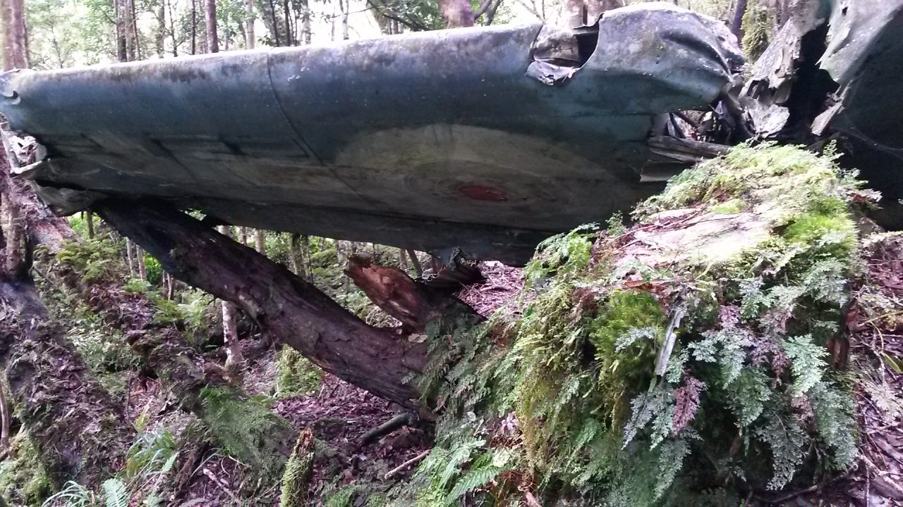
From accounts on the internet I've figured where the plane wreck is but it turns out to be a little higher than I was expecting - after 700m and once the spur starts a steep climb. I first notice a lot more markers then a piece of aircraft on a stump to the left of the track marks a further piece. Soon after, pink ribbons lead around the slope to the right and down to the iconic wing section of the plane.


 As with other wrecks in the Tararuas there is debris spread across the forest floor, mouldering into the humus and merging with the trees and undergrowth. A section of broken engine block testifies to the force of the impact. With a bit more time I'm sure there would be plenty more to find but this is not the purpose of the trip.


This seems to be as far as a lot of people go as the track from here up is a lot less traveled. 20 minutes later at the ridge a plastic plane and markers indicate the top of the spur. 

It's about now that I am most regretting the location of my compass. Although it should be straightforward, the trail is often indistinct and the ridge top very broad and flat in places. The sun periodically sneaks through a gap in the high canopy and my shadow provides sufficient indication of direction to keep things ticking along. I am conscious though that I need to find the top of one spur heading west off a very broad ridge top. The forest is mixed but there is some beautiful sections of tall trees above a mossy floor. And lots of fallen branches to work around.

As it turns out, I blunder into some ribbon markers and a foot trail - I'm thinking that it is heading towards Tangata Maunga and a marked clearing (which would be good to find) but getting suspicious I check the compass and discover that it has veered west - and in fact turns out to lead to and down the very spur I'm after.

The map shows a marked 4WD track starting not too far down the spur so I enjoy the last moments descending through bush on the sharp spur. Fresh footprints indicate that someones have descended before me today - and pretty soon, quad prints indicate that they didn't make it up here under their own steam.

Things speed up markedly at this point but I keep map in one hand as I trot down, almost passing the 4WD track that dives down through a tunnel of trees to Waitohu lodge - a private hut with a rather stunning view.  The quad has been here too. 2pm - time for a drink and a bite.


Waitohu Lodge

The view


Spot-height 495 is a little off the main track so I follow the quad tracks when they take a left turn - more foot prints indicate that someone and their dog left the quad to head down almost as far as 495. I assume after pigs because there's not much else to see. Back on the trail I pick up pt 533 then pop off track over three lumps to make sure I have picked up 477.

Old boiler

The final point that I want to visit has a name - Ringawhati. It turns out to be on the edge of farm land with a rather splendid vista. In deference to the thought that this might be named after someone's Tupuna I don't sit on the point itself - and wonder idly whether the evidence that a cow had done more than sit there was more or less disrespectful.

A quick internet search determines that Ringawhati could mean broken arm or gay man (possibly a more recent reference to a limp wrist?), but more interestingly throws up references from the Otaki Maori land court from 1874.  It seems to relate to a block of land and clearly is a long standing local name.


Ringawhati


Back on the road I follow the quad tracks down the hill confident that if the quad could get through then so can I. At the bottom the ute is gone - the paradise ducks are still there and kick up their racket as I trudge along the road with a lone kotare leading the way. 4.30 at the car.


Postscript

As per yesterday's trip - this isn't my favourite haunt in the Tararuas. However it is fun to kick around and the bomber adds some interest. Stumbling over old logging trails gives some idea about the previous use of the land and you could spend days just following to see where they lead. I'm pleased to be able to say I have some passing familiarity with the area now but I don't think I will be back anytime soon.

Sunday, 20 November 2016

Cattle Ridge loop

It has been quite the week, from four hours at the top of Wainui Hill in the wee small hours, feeling the aftershocks roll through, to a day watching the turbid Hutt River crawl up the stop bank. A bit of a tramp is surely indicated.

There's a stretch of the Ruamahanga River that I have been meaning to explore. The major river systems in the east of the Tararuas trace a line from Eketehuna to Kaitoke and I haven't got around to travelling the section from Roaring Stag Hut to the bend at Cleft Creek. It's not marked on the topo map but it's a known route and there's a reference in Tararua Footprints, albeit a little light in detail.

This weekend there was only one day available for a trip (after visiting Iona's most impressive weaving exhibition on Saturday), so I figured with an early start I could build a day trip around an exploration down river.

What:   Day trip
Where: Ruamahanga - Cattle Ridge Loop from Putara
Who:    Solo
Why:    Check out Ruamahanga River and Cattle Ridge
When: Sunday 20 November 2016
Map:   Map

The alarm goes at 4am after four hours sleep and I pour myself into the car for the 2 hour drive. The Putara Road End is tucked into the hills behind Eketahuna at the head waters of the Mangatainoka River. It's been a bit of a mecca for trampers over the years as the kick off point for the SK (look it up!). Unlike the hob-nailed boots that have walked this way before, I have the good fortune of not having to catch the rail car and a taxi to get here.

Morning at Putara Road End

The sun is well down the hills at 0640 as I leave the car at a relatively crowded car park (4 cars). The track is good along the river, up to the junction then the long amble down the ridge to the flats near Roaring Stag Hut.

Foot prints on the track indicate that there are a likely to be a few people at the hut. Sure enough there are two parties in when I arrive, an hour 45 after leaving the car. It's shaping up to be a sunny day.


The view from Roaring Stag

From here it's tiger country. I follow the track down to the Manuka Flats where the Cattle Ridge Track hives off west. At first I try to find tracks across the flats, but pretty soon the flats run out and it's a question of picking ones way along the river bank. The rain during the week means the river is up somewhat, so there's a bit of wading required when it carves in against the bank. There's quite a few slips along the way, some of which have been recently active. At times there are terraces that can be followed, but I don't see any evidence of trails or pink ribbons and inevitably end up in the river again.


Another slip

With the river up it's a bit slower going than expected, with a few sketchy scrambles on unstable erosion scarps required to avoid deep bits. Eventually the river enters a short gorgy section. There is no way I'm going to try to cross, as the river is deep and swift. There are enough hand holds on the rocky bluff and foot holds under water (no idea how deep it is) to clamber and float along the edge and around the corner - keeping well clear of the main current.

On the other side I find a slip as indicated in Tararua Footprints and scramble up. However, I find a large creek, which I quickly realise can't be Cleft Creek, so have to drop down another slip to the river - disturbing a deer on the way.

Random stream that is not Cleft Creek


Shortly after, yet another slip presents and I nip up to a series of old terraces. It's pretty easy travel but I can't find any indication of tracks. I potter along keeping the distant sound of the river on my left until I come across what is undeniably Cleft Creek. Undeniable as it is at the bottom of a large ... well, cleft. It's quite pretty, with clear water tumbling between steep mossy banks amidst mature forest. A few deep pools discourage me from looking too hard for a way down. Somewhere on the opposite side is the main track in from the Ruamahanga Road end.

It takes a while to follow up stream on the old terrace before I find a route down just before an old erosion scarp.

Another slip

It's further still before I look back and see an orange triangle. At some point the track has joined the creek. Two minutes later the route leaves Cleft Creek and starts climbing a side stream. It's taken about two and a half hours from Roaring Stag Hut. I think it would be somewhat quicker with a lower river, less chest high water, and fewer unnecessary excursions into the bush.


Cleft Creek looking down stream - first orange triangle on right somewhere 

Junction on Cleft Creek - route heads right

The side stream rapidly becomes a lot smaller but it is fairly easy and open travel. Marking is a little variable, and there are a few points where a little vegetation clearance or another marker wouldn't go amiss. I rock past the point where the track hives off up a spur towards the saddle, finding it beside an almost invisible tributary when I return looking for the last marker.

The track to Cow Saddle is also poorly marked in one section, where it traverses around the slope to the final short climb to the saddle. Approaching the saddle though, the ground trail is clear and in the saddle itself the turn off for Cattle Ridge is elegantly indicated by a classic old wooden sign.


Cow Saddle

It's about 11:40 so I figure time is going ok and there's no need to take the bail-out option back to the Ruamahanga Road end. There's a small matter of a 700m climb, though. It becomes rapidly clear that there hasn't been much track maintenance through here for a while. The track is covered in wind-fall, most of it small stuff that would be easily cleared with hand saws, and the occasional large tree that's created a bit of a mess.

Where's the track?

I've never been up this track before. It climbs steadily and is pretty easy to follow. It slowly opens unfamiliar perspectives on familiar Tararua features. Shortly before leaving the bush line I'm a little surprised to cross an active little stream - it looks big enough to possibly even be present in summer.


Down the Waingawa River - Cow Saddle to the left

Cow Saddle through to Te Mara on the horizon
Blue Hut would be just to the left somewhere

The track exits the bush line and works up through the scrub into tussock country. The bare tops start to dominate the horizon: Table Ridge to the south-west, gradually revealing more and more of Tarn Ridge at the headwaters of the Waingawa, the bush clad Blue Range in the east and Tawhero in the north east.

Spur up to Cattle Ridge - Ruamahanga River runs towards Mt Bruce (right of centre)

The wind gets a good run up out of the Waingawa head waters and slams into the spur, but then eases as the track climbs in the lee of Waingawa.


Approaching the top - looking north along Cattle Ridge


Approaching the top - SSW to Waingawa
That could be Banister behind?


Um, I think that's Table Ridge on the left


An hour and a half after leaving the saddle, Cattle Ridge is as round-topped as the map promises. Today it is quite clear to the east but the cloud lurks high above and thick around the peaks on the main range to the west; a strong cold wind cuts across (WSW?). We should stay clear today but I could imagine it being pretty bleak up here in clag.


Down the Ruamahanga

The top - Waingawa to Bannister on left, Dundas to the right with its head in the clouds

It's easy travel but cold enough that after a bit I give up and put my rain coat on - although the sun is coming through the wind is pushing me around a bit. The ridge top undulates along but I am waiting for the notch between Pukekino and Pukeroa. It is apparently about 100m down and up through tussock and spiky Spaniard.


Further along Cattle Ridge looking back 

Probably Bannister

There seems to be more of a foot track towards the east side of the ridge and down into the notch - not much though. There's a bit of scrub and quite a bit of Spaniard - some of it brown and tough, some green, soft and more flexible, but still spiky. I try to avoid stepping on it - partly because running shoes don't give much protection - but also I have a bit of a soft spot for it. We have few enough plants and animals that bite, sting or poison that we need to take care of those that do.


In the notch looking back


In the notch looking forward

Annnnd, looking across the notch to Pukekino


Cloud on the main range - spur to Dundas Hut almost visible just above shoulder

First view of Cattle Ridge Hut (dot on spur in middle)


Once the route from Dundas Hut joins Cattle Ridge there are markers, cairns and a ground trail so it is quicker going. Soon after the track heads off the east side of the ridge and down to the hut. There are a bunch of foot prints in the mud so someone has been through today.


Main Range panorama from near the end of Cattle Ridge
East Peak at right end - clouds magically gone again

It's taken a bit under an hour and a half to traverse the ridge to the hut and it's nice to get in out of the cool. This hut has been the source of a bit of controversy, with plans to remove it the subject of some criticism. There's a new wood shed, supplies for repairs and a new deck - slow going but a good start.

The log book indicates that a group of runners have been through doing the Dundas Circuit in a day - quite a trip.


Cattle Ridge Hut - not that pretty but there's a bit of work being done.

Next is the knee crunching descent to the Ruamahanga, almost 700m below.  It's a nice wee track down through scrub, then into forest, arriving at the river an hour after arriving at Cattle Ridge Hut.


Roaring Stag way below
Probably Tawhero behind 

Roaring Stag Hut

It's around 3.30 as I wander into the hut. An older couple have come in for a couple of days and have already read the log book, as they ask if I'm the bloke that had signed through earlier. They look set for a good couple of days with great weather in a comfortable, empty hut. Look most old school trampers they are thoughtful about their environment - he asks whether he should take a hand saw up Cattle Ridge tomorrow (not needed) and has already noted some of the rubbish around the hut that he will carry out.

After a short chat I head off, with the afternoon sun filtering through the canopy. It's a bit over an hour to the junction, then about 45 minutes to the road end I bump into a couple that have come down from Herepai Hut, after deciding not to head up and over to the Mangahao River because of the weather on Saturday.


The Junction
I wasn't expecting to be getting back to the car in daylight so it feels like a bonus to be hitting the road around 5.30pm.

I can feel that I've had a fairly active day and am sporting a few more minor bruises, scrapes and punctures, but nowhere near the beating from some of the recent bush bashing trips. However, it's a few days before I stop making old man noises every time I go to stand up.

The river section was a little more complicated than I expected, due to the high flow and a few unnecessary scrambles. I wouldn't like to do it in the dark. The track up to Cow Saddle needs a little attention to the markers, and the track up to Cattle Ridge definitely needs a tidy up. Cattle Ridge was really enjoyable - the views are great and it's a nice amble on a good day.  Don't expect a beaten track though. The track down is steep but pretty good and the track out is good apart from a fair amount of winter mud up to the junction.

A good day trip.