Saturday 25 March 2017

Rae Ridge

Rae Ridge - not a highly familiar Tararua name. However, if you asked me about the area between Judd Ridge, the Waiotauru track and Renata Ridge the answer would most definitely be something about unfinished business.

Missions into Otaki Forks generally entail whistling off up Judd Ridge (southern crossing or main range), Waitewaewae (Te Araroa trail and main range) or Waiotauru track (towards Akatarawa Hill road). But there is also a chunk of not-officially-tracked countryside to explore with plenty of remnants from the bad old days of logging.

I've stashed this trip away for a rainy (but not too rainy) day and this weekend promises just that. The plan is to cross the Waiotauru River (first thing so that if uncrossable I'm not stuck on the wrong side), head up Rae Ridge to Dennan (1214m), follow the track up Judd Ridge to Kime Hut, assess progress and, all going well head down the ridge west from Field Peak (swinging to north west) dropping to the confluence of Eastern Waiotauru River and Tregear Creek, follow the river down to the Waiotauru track and back to the car park.

It looks like a bit of a distance and a bit of a climb - depending on the nature of the bush it could be a bit of a struggle to get around in a day. I pack for an over-nighter with a bail-out option down Judd Ridge to the car.

What:   Navigation trip
Who:    Solo
Where: Otaki Forks: Rae Ridge and Eastern Waiotauru
Why:    New territory and nav practice 
When:  25 March 2017
Map:    Map


At 6.50am on a cloudy morning there is just enough light to find my way from the Ridgeline track car park to follow the road down onto the terrace and from there to the river. The river is up a little but it is a good wide point to cross and with the aid of a stick I'm soon following a foot trail through the grass on the opposite terrace.

The trace leads to Sheridan Stream then follows up where it exits the hills past a notice indicating a 1080 operation a week ago. I follow for a bit thinking there might be a route on to the base of Rae Ridge but eventually realise this is increasingly unlikely so bash straight up through the bush.

Once on the toe of the ridge ground trails quickly become apparent and there are clearings. Soon there is something that looks like an old logging trail that, although overgrown, provides better travel. This continues until somewhere over 450m.

As the day brightens it reveals clouds low on the surrounding hills. The lack of view is no great hardship as, after the low level clearings, most of the rest of the ridge is under a high canopy.


From toe of Rae Ridge - Otaki Campsite just out of sight on right

I don't notice much in the way of markers but it is mostly reasonably easy to follow the ridge with just the occasional use of map and compass where it widens. There is the usual undergrowth concealing the odd stump, one of which I bang my thigh into at full noise. After a few anaesthetic expletives I continue with a bit of a limp.

At one point a small and unexpectedly green patch on the ground turns out to be a 1080 bait, quietly degrading into the forest floor. A few meters on is another and shortly after another. The presence of bait I guess is a good thing - a) control activities are being undertaken, b) the operation has successfully achieved the desired low density of bait coverage and c) there's not so many pests around that the baits are all getting eaten.

A couple of spots on the ridge look like they might be a bit of a challenge but even the one where my over-folded map has developed a hole proves no problem. I try to keep a reasonably steady pace and generally find a bit of a ground trail, reaching the bushline finally around 1030am - about 3.5 hrs from the car (approx. 1150m).


Slightly damp and not much to see but making progress


Claggy spurs - Judd Ridge on right


From Rae Ridge - looking up Judd Ridge towards an obscured Bridge Peak

After clearing the bushline the ground trail follows the top of the ridge amidst clag that comes and goes. Glimpses up and down Judd Ridge appear then fade. It's not cold but in the open and pretty much soaked through it's more comfortable to keep moving.


And the clag closes in again.  Down Judd Ridge towards Table Top - from Dennan

From Dennan (11am - four hours on the go) the civilised line of the Southern Crossing track with orderly markers meanders through the tussock.  I turn south and head up over familiar terrain into the cloud - next stop Kime hut.


Kime hut emerging from its usual habitat - cloud


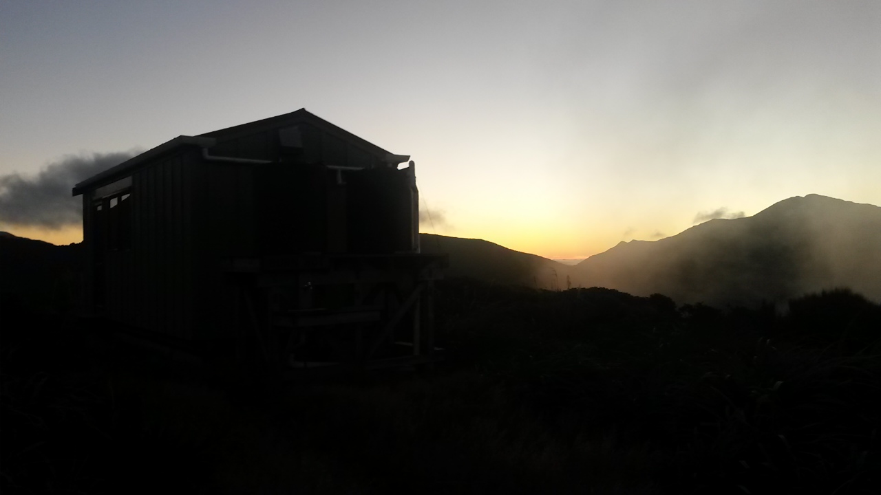
After seeing no-one on the track and no recent foot prints it isn't surprising to find an empty hut. The new hut is a far cry from the old one - it is even slightly warmer than the outside environment. I'll chill down pretty quick without moving though so don hat and gloves after filling out the log and looking for tips from anyone that may have followed the same route (no luck). 

The time is pretty good and although this is now the tricky part of the trip, it is down hill with plenty of day left so I'm comfortable to make the call to continue. Kime has good cell cover so I get confirmation from home support that my intentions have been received.

From here the target ridge should be pretty easy to find even in the clag, but there are a couple of points on the way down where I figure some care will be required not to drop off a spur.

The prolonged stop (half hour) has got me a bit cool so I'm well wrapped up for the short wander along the tops to a faint trail towards the spur. The spur is easy to find but the ground trail comes and goes. With the lack of visibility I use the altimeter and compass to confirm the route and after a bit of a scramble find a way through leatherwood into the bush. Almost immediately there's an old marker confirming I'm on the ridge and promising that there might be a bit of assistance.

Sure enough there are more markers here than I noted on Rae Ridge and a reasonable ground trail. There's still a bit of need for map and compass though and I keep a close eye on the altimeter. The good news is that despite the clag there is no more rain.


Shelf fungus and top shelf fungus


Stepping around a log I'm startled to find myself staring into the eyes of a goat from five meters away. He is sporting a reasonable set of horns and is pretty adamant that he isn't going anywhere. In fact he snorts at me. The impasse holds for some moments until I buckle first - he's not actually in my way so I continue, leaving him to his territory.

The leg is niggling a bit and I'm starting to feel the lack of serious exercise in recent weeks so set a bit of an easier pace for the middle section of the ridge and take a bit of a breather.

My plans for the toe of the ridge are a bit vague but I figure that there'll either be some markers to follow or the spur running west than north-west looks promising.  In the event around about 540m I stumble over a length of stainless cable and shortly after, an old logging track. It drops steeply towards Tregear Stream. The markers have disappeared so there may be an easier way down that I missed but the logging track must get to the bottom so I commit to follow it.

The track drops down slope angles that I can't imagine you would get anything other than a bulldozer up. Some sizable trees and dense groves of saplings cover the old road bed with punga growing in the damp cuttings.


Cutting through


Middle of the road


As the road drops steeply towards the stream there are a couple of spots where slips have swept it away. Scrambling across and following the line, the road soon appears again on the other side. It's a remarkably civilised route down but once in the river bed I lose sight of where the road may have run so I'm soon bollock deep in Tregear Stream. It's 4.20; about 9.5 hours on the go.

The stream is not so big but reasonably energetic and deep in spots. I scramble down getting to the confluence with Eastern Waiotauru 10-15 minutes later.


Eastern Waiotauru has a bit of water flowing

The Eastern Waiotauru is somewhat larger in a steep sided valley. I am soon bollock deep again with frequent crossings required to avoid deep pools. The rocks are lethally slippery and a stick becomes necessary. I'm not sure if I missed a trick here. I can't figure how they got the vehicles to the track up the ridge but can't see any sign on the slopes above.


And it's a little gorgeish 


Some local fauna

It takes a while to get about half a km down stream and I'm eyeing up the next stretch of river when I note daylight through the bush up the left bank. A short scramble and I'm on an old vehicle track - well benched into the hill, wide and solid. Things speed up.

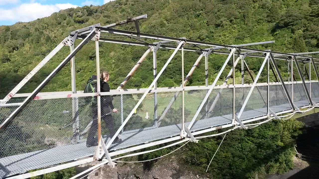
The old road sidles around to the Waiotauru river valley where the main track joins to head further up valley and eventually to the Waiotauru Hut. I reluctantly leave the road to follow the track down to the bridge and the 5 odd kilometres back to the car park.    


Waiotauru River - about halfway back from the bridge to the car park


Old steam mongery 


Looking across at bottom end of Rae Ridge - Sheridan Stream valley on left


Sheridan Stream valley


The track is good and well marked. It potters up and down and there are a few slips to bypass. It's mostly in bush but there are occasional views down and across valley and some grassy clearings. The bottom end of  Rae Ridge shows signs of an easier access route then the one I followed and a visible scar from an old road.

Almost 12 hours after setting out I'm back at the car - a bit sore from a longer time on my feet and faster pace than recent weekends but quite satisfied with the day's exertions.


Saturday 18 March 2017

Burn Hut

Tramping with other people two weeks in a row - this is getting to be a bit of a habit.

Jenine posts a trip to Burn Hut on Meet-up around Wednesday and I am in two minds.  I have been meaning to visit that area for a while and transport is a bit tricky - but on the other hand I do prefer pottering around on my own and not having to worry about group decision making. On a bit of a whim I hit the 'I'm going' button and put my original plan on the back burner.

What:    Overnight tramp to Burn Hut
Where:  Mangahao, behind Shannon
Why:     New hut, new track and hopefully a little bit of navigation
Who:     Rodger, Jenine and me
When:   17-18 March 2017
Map:      Map

In the end there are just three of us and we get away from Wellington a bit after 1.30pm on Friday. It's a smooth trip north and no problems finding the Mangahao Lower No. 2 reservoir.

We park next to a Mazda 6 by the dam and try to guess who might have headed up the track to the hut ... not really a hunter's car, two coffee cups, children's toys, invoice from Levin shop ...


Typo in the second to last line perhaps ...


Janine and Rodger rearing to go


View up the reservoir

And they're off


Down river


It's a pleasantly sunny day as we head across the dam and into the bush about 4.30. The track runs down the true right of what is left of the Mangahao River - water is piped through the hill to the No 3 reservoir then through another hill to the Mangahao power station while the rest of the river is left to meander north and east to eventually join the Manawatu river shortly before the gorge.


The track is in quite good nick and is easy to follow. A couple of side streams are small enough to mean no wet feet and the last larger one has a bridge. The track turns and climbs under a high canopy, there aren't many view spots although we get a nice wee view at one point up the valley to the tops near the hut.

Our pace is pretty slow so the sun is heading to the horizon as we enter the scrubby 'tops.' We are well below the normal bush line but an old burn means the vegetation has still not fully re-established. Someone has however cut a wide swathe for the track so it is pretty easy going. Although, as the track turns south and west the going gets a little more overgrown. Jenine is taking point and very decently finds all the holes for Rodger and I to avoid.

On the horizon we get a brief glimpse of Mt Taranaki before mist starts rising from the valley.

Looking northish - hut is on the spur in the left quarter

Jenine forging ahead

Last of the light behind 'Peak'

Burn hut and the first of the evening clag

The hut is in sight and less than a kilometer away as the sun sinks below 'Peak', so we arrive in the light around 7.45.

A hunter is well settled in - when we arrive he thoughtfully removes his rifle from the common area and stashes it by his bunk. He turns out to belong to the Mazda ("it's actually the wife's car") and says he is expecting a mate to turn up after milking. Rodger pulls together a very decent con carne, potato, nacho, cheese and sour cream dinner and we chat until a crashing and scrambling indicates his mate and dog have turned up.

He reports that it has clagged right in and the overgrown section of track caused him a couple of moments of indecision trying to find the track, although the dog was quite clear where to go. We now have 5 for a 6 bed hut with a dog in the vestibule. The hut is comfortable and warm despite the rising wind outside. Both hunters are clearly quite familiar with the area and are happy to tell us about their favourite spots.

Outside, the clag is blowing up from the valley below and swirling around the ridge, but above is a clear night sky. It's not a bad wee spot.

There's a bit of a moment when the young dog gets a bit excited and bites Jenine. It's quite a chomp but no broken skin. The owner is mortified and whenever anyone heads towards the door he is quickly on hand to keep the dog in check. It has a bit of a jump at me at one point also but no harm done. It does, however confirm my view that dogs don't belong in busy huts and if they are near a hut they should be well trained or kept away from others.

The next morning is grey but the weather forecast indicates that we should be ok before a southerly change and rising wind and spot of rain in the afternoon. Having studied the map I'm interested in an option that Rodger has also identified - following the track towards College Stream then leave it to follow the ridge south for about 2km to come down the Puketurua track.

The hunters indicate that this should be fine and that the Puketurua track is well traveled. The ridge looks gentle and straight forward to navigate but it will be the ground cover that might be the kicker. The hunters also suggest the section down College Stream may be a bit slow going. We decide to head to the ridge and make a call when we get there.


Rodger set for the weather

Burn Hut catches a patch of sun

Clag is scudding across the ridges and we are periodically in cloud. There's a short, gentle climb from the hut to what looks like a trail leading left towards Taramea (and maybe north along the ridge beyond?) then the track skirts along the ridge in a southerly direction.

We are keeping an eye out for an obvious trail to follow along the main ridge but end up just over shooting it. Rodger spots it when we back track a few meters - it skirts around the west side of a wee knob before the saddle to 835.  The ground trail is a bit over grown but shows signs that it has been cleared at some time in the distant past.


Jenine is somewhere in the scrub there

Easy going at last


There are quite a few spots where the trail across open scrub is difficult to follow and we end up finding our own way. There's also a bit of bush with occasional old tape markers.

It's not too bad travel overall but there is a fair amount of pushing through  scrub and some scrambling required. On the plus side the cloud lifts and the day becomes warm and pleasant. The wind drops and shifts to the south but it remains calm.

Approaching the top of the Puketurua track there is a wide cut swathe along the ridge and the going gets easier. The top of the track is not so easy to find though as it is somewhat overgrown - not quite what the hunters indicated. However, it follows a clear spur down so it is pretty straight forward. When we reach the tree line the going gets easier again and we potter on downwards.

There are a couple of spots where we cast about briefly for the track but the spur is quite well formed and it's pretty easy to follow. Jenine and Rodger have GPS apps on their phones so I don't even have to get the compass out.


First glimpse of the top reservoir down Pakaturua spur

There are some old school markers but no orange triangles - on my 2011 topo paper map the track is marked and named but I note that the online topo map has dropped the name. I assume it is no longer being maintained as a track - however given that it is still on the map I take the opportunity to whip out the bush saw and do a bit of track clearing on the way.

Lower on the spur someone has done ridiculously extensive marking with blue spray paint for downwards not upwards travel. The bottom of the spur steepens and we are soon clambering down hanging off roots and saplings. At the bottom the track emerges at Baber forks - a sign points up College Creek to the track we could have taken (Mack's track) and orange triangles give us the choice of following the stream down to the reservoir or sidling through the bush.

I'm feeling a bit guilty about enjoying the off track sections which haven't been as much fun for everyone so volunteer to go on ahead and bring the car up from the lower reservoir. There's not much point everyone walking the 4km of road.

The reservoir is reasonably full so the hunters suggestion that we cross to the track on the other side is not a goer and there is no space to skirt along the shore - the sidle track is not too bad although I miss the start of it and cast about in the bush a little before hooking on to it. Rodger and Janine later report the same experience. It's a short way to the dam with a brief pause to clear the branches around a tree fall.


No 1 Reservoir


Looking back up the reservoir to our ridge

At the dam there are three cars so the road is clearly navigable. I divest a few layers and trot up the road in the afternoon sun. Just short of the 2nd dam there are a couple of hunters heading up the road so I pick them up on the way back. It turns out they heard us go by on the track this morning and have just come back down the way we came in yesterday. They say there is a large family party heading up to the hut so I suspect our hunters from last night will be re-evaluating how long they stay (especially with kids around the bitey dog).

Back at No 1 reservoir Jenine and Rodger have been waiting in the sun for about 10-15 minutes and sensibly haven't started down the road. Rodger decides to take a quick dip in the dam before we head off for an uneventful trip down the coast.

Post Script

The track up to Burn Hut was easy to follow. The hut itself is compact but tidy and warm - it seems it gets a bit of traffic from hunters, and day and overnight walkers. The route south along the ridge towards Ngapuketurua is reasonably straight forward navigation but there isn't always a good ground trail. It's not as bad as some of the Rimutaka tops but those of a shorter wheel base or carrying walking poles might find it a bit of a challenge.  Puketurua track is pretty good but a bit of a scramble at the bottom, a bit over grown at the top and there are one or two spots where you may need to check your navigation. The route from Baber Forks to the dam is not too bad but the marking can be a bit confusing in places - if you are following your map you should be able to work things out pretty quickly though.

Saturday 11 March 2017

Ruapehu

It's unusual to be heading out on a trip with a bunch of others. However, Mike has taken on the task of organising a club trip to Ruapehu with Tony and there's one seat left in the two vans going up - the intent: a mass assault on the summit.

This will be my first tramp with others in a while and I'm a bit reticent about going out in such a big group. However, I've never got around to the top of Ruapehu before and also figure there's a fair amount of learning to be had.

What:    Wander up Ruapehu
Where:  WTMC Lodge, Iwikau
Why:      Not been to the top before
Who:     A million WTMCers
When:  11 March 2017
Map:      Map 

One of the reasons for going on so few club trips becomes apparent during the course of the preceding week. The weather forecast deteriorates and although it's clear we won't be getting to the top, the relentless momentum generated by the complex logistics of getting 24 people up, accommodated and fed means there trip will proceed. I'll also note at the outset that the weather meant I left my phone in my pack all weekend so no photos I'm afraid.

Bang on the dot of 10 minutes late we leave platform 9 and head north for the traditional Friday afternoon traffic jamb up the Kapiti coast. I have claimed a seat in the back corner of the van and settle in for a long trip.

The new Kapiti express way seems to be working admirably as we have no hold ups and a smooth trip north, with the usual stop at the Kebab shop in Bulls. Mike has the foresight to ring his van's orders ahead so their food is ready when they arrive. We continue in the dark arriving at Iwikau (Top of the Bruce) a bit after 10pm. It's drizzling as we stand around in our coats while the person in the hut fails to wake to repeated banging on the doors and windows.

Someone eventually climbs in a window and we claim our bunk rooms.  I'm sharing with Mike and Tony and have remembered my ear plugs so have a comfortable night.

In the morning the weather looks very settled - solid rain, close clag and a bit of wind. The lodge is at about 1600m so the wind at the top (1000m or so higher) is likely to be fearsome. As Mike cheerfully points out: "Ruapehu is protected from the weather by Mount Taranaki in the west and the Kaikouras in the south."

Tony and Mike pick some lower altitude walks with a view to some sodden exercise and possibly views of water falls and lakes.  Mike takes a van load down to a walk to some waterfalls near National Park and I elect to follow Tony and six others on a longer walk to Tama lakes.

We leave the van at the Tama track entrance and set off, well wrapped against the elements. Despite the weather there is a fair few other people on the very well formed Taranaki falls upper track. Pretty soon the rain has dropped away and we're stopping to peel off layers.


The track sidles through gentle landscape and some nice bush, but mostly open tussock and scrub. We stop briefly above Taranaki falls but don't go down as we will likely be taking that track on the return.

The track meanders and climbs with none of the streams looking particularly swollen (Tony guesses that they are more locally fed and the rain is further up the mountain). It feels a bit weird to be relying on someone else for navigation and decision making but it's a good opportunity to watch and learn from an experienced tramper.

Where the track reaches the edge of the explosion crater around Lower Tama lake we scramble down and grab a bite of lunch before heading across the wide, flat and bare crater bottom to the lake edge. Despite the clag the water is blue. A creek flows into the crater but disappears into the flat bottom before reaching the lake - and the lake itself has no outlet so there is apparently some considerable underground drainage at work.

At the lake edge we skirt to the north before heading up the east wall at a spot Tony knows, although it isn't marked on the map or obvious from a distance. This takes us on a steep scramble to the top. The wind has picked up and intermittent showers come through.

There's no problems with timing; the party isn't fast but Tony obviously figures that the weather is settled enough and the party capable enough to head up to the Upper Tama lake. We head north up the spur to  1450, sidle along the east face before crossing to drop down a stream to the south shore of the upper lake.

The clag is still close around the peaks but down by the lake is more sheltered from the wind. Time is still good so we decide to circumnavigate the lake. There are indications that others have done this although we get to a section on the western shore where the bank drops steeply to the water. There seems to be some indication that a trail climbs up the crater wall to get around the section.  I watch the leaders scrambling up and decide to do a reccy nearer the waterline, sure enough there's a slightly acrobatic but quite feasible route around.

As I sit in the comfortable moss waiting for the others to complete their scramble I contemplate the decision to depart from the group line to follow a path with a slightly higher chance of a slip but with significantly reduced severity of resulting harm. It's the line that I would follow on my own but perhaps I should have just gone with the group. On balance though we were never far apart so I reckon it was within reasonable bounds of finding the route that suits you best without putting others at risk.

We continue around a sandy than bouldery shoreline with wavelets lapping at our boots until we reach another section where the beach disappears.  I'm not so keen on following the lead group into thigh deep water, and this time find a well formed foot trail along the bank above. This takes us comfortably around the rest of the lake and up the west side.

The track doesn't seem to be official but is clearly reasonably well used. I can only assume that people are either heading towards Ngauruhoe just a couple kilometers away or east to pick up the Waihohonu-Oturere track.

The clag closes in and the wind rises as we climb out of the crater to rejoin the upper end of the marked trail we left before lunch. The going gets easier, as we drop down and we are soon following the well formed track back to Taranaki falls.

Tony and I are bringing up the rear and stop to chat with a couple of women who are on the around-the-mountain trail. They sound like they are from the US and one of them has three vertical lines tattooed on her chin. I wonder if some native American tribes have a similar practice for facial tattoos for women as Maori moko. If so I imagine she would get a pretty positive reception in New Zealand.

The falls are pretty with a sizable stream dropping off a lava bluff  through a narrow slot. Most of the party clamber in behind to be immersed in the spray and be close to the force of the crashing water.

The track then follows a tongue of forest down along Wairere stream before sidling through more open country with views of the Chateau and back to the van. The weather has considerably cleared and it is apparent that down country has been much better than the slopes of the mountain.

All up, 8 pretty easy going hours and despite the clag and a bit of rain some quite pretty country side. A good day walk.

The next morning is claggy and rainy again. After tidying the lodge and packing, Tony takes a group of 14 with the intention of wandering up through the ski-field and possibly as far as the bottom of the glacier. (I couldn't find a name for it on the map - it's a little one that feeds the stream that runs through the ski-field). Mike takes the remainder to either walk the Old Coach Road or sit in an Ohakune cafe.

A 4WD track takes us up to the top of the first chair and to the stream beyond (top end of the Whakapapanui stream). Visibility is low so we keep the group reasonably close together.  It's difficult to picture the landscape as I normally see it - covered in snow and skiers.

We roughly follow the spur up until first an implement shed then the cafe loom out of the clag. The lee of the cafe is a chance to regroup and add a layer. From here we follow the line of the Knoll Ridge T Bar to the top with a brief pause to cram into the emergency shelter for lunch.

Above the T Bar we come across the first snow - it's a bit hard on top so most of the party stick to the rocks as we sidle and climb a short way to a snow field with a stream flowing out of it. This is close enough to the bottom of the glacier for our purposes so we stand around in the rain for a bit contemplating what it might look like in something better than 20m visibility.  We're probably at a little under 2300m so it would be just a 300m climb to the summit plateau with nothing to see. And probably a bit of a risky scramble on icy snow to get there.

Retracing our steps is of course somewhat quicker with just a little bit of casting around to find the best way down the spur to the true right of the waterfall.  The volcanic rock is incredibly grippy compared to the Tararua streams I am more accustomed to, so you can boulder hop quite comfortably.

Back at the lodge we change in the vestibule to minimise the need to tidy up then scamper back through the rain to the van.

Mike is just picking up the other party when we get to Ohakune so we convene for a pretty good late lunch at the Mountain Rocks Cafe.

The trip home is uneventful and it's still daylight when we arrive in Wellington. Not my usual weekend trip and the weather was pretty awful but quite enjoyable.