Showing posts with label Mick. Show all posts

Sunday, 1 October 2017

Waitohu Stream and there abouts

Day two of a weekend mopping up spot-heights in the western Tararuas.

I have seldom had troubles with mosquitoes in the Tararuas so am somewhat affronted by the carnage the blighters have wrecked during the night. The itchiness is not helped by lack of sleep, courtesy of the chap playing late night music. Still, at least the rain didn't reach my sleeping bag.

In the predawn dark I pack up and head off to Otaki BP for breakfast and the start of day two.

What:    Day two of two one-day navigation trips
Where:   Back of Otaki - Waitohu Stream
When:    1 October 2017
Who:      Solo
Why:      Mopping up orphan spot-heights and ventura bomber
Map:

The day's ramblings - part of yesterday's at upper right


One pie later it's light and I head to the quarry in the hills behind Otaki. The second gate is locked so I park the car on the road edge and (7:15) follow the road up valley (right across the bridge just past the quarry office).

A couple of kotare watch from the wires above and skip ahead a lamppost each time I get near. The quiet morning is disturbed by a pair of paradise ducks that honk and squeak respectively to warn of the interloper, then the harsh staccato rattle of a spur winged plover cruising into land in a nearby paddock ... not the most beautiful dawn chorus but familiar sounds to lift the boredom of the farmland.

I idly note a ute parked by the last bridge with ramps off the back - and slightly begrudge the fact that he must have had a key to the gate. My route lies directly ahead up a spur leading to Thompson. Almost the entire block of pines I am heading through has been clear felled - the activity has moved to the fringes of the block and there are no signs of movement today so I figure it's fine to traverse through.

The loggers have followed a tongue of pines all the way to the bush edge; about 400 vertical metres on logging tracks. The last part is churned up by log haulers so a little more porridgy, but overall easy climbing and an hour from the car.

From the bush edge

From here up there is a ground trail through bush with sporadic pink tags as markers. At the top I emerge onto a wide, muddy trail with lots of foot prints.  This is the trail I saw on Mt Thompson yesterday. There's a spot height at 639 so I squelch my way upwards.

This whole diversion is simply to pick up four spot-heights within the park boundaries, so after following the trail down to 592m I decide to find the quickest route to the bottom via pt 395. It is now that I discover that my compass is not hanging in its habitual place around my neck but is nestled safely on the front seat of the car. For a navigation trip this is a somewhat aggravating development - and being a solo trip there is no-one with which to share the blame. All is not lost as my watch has a compass but it's nowhere near as functional.

The route down from 592 starts well with an old logging track heading in exactly the right direction of down that I am after. It deposits me on the marked logging trail down from Mt Thompson which is in very good nick (a fallen log indicates no 4WD access).


Ubiquitous logging trail

When I drop off this trail to pt 395 it is to discover an older trail not far below - in not so good nick. The face below here doesn't really have any defined spurs so I just crash down through supplejack and rotten logs to emerge by the sizable but unnamed stream off Mt Thompson.

It's a little way to the mouth of the stream to pick up a track that behaves almost nothing like the one on the map. However I manage to find myself to the base of the spur I am after and the track does indeed follow up beside a side stream for a ways. A crude aeroplane shape made of markers on a tree just as the route dives upwards confirms I'm in the right place.

Once again I find myself plodding steadily upwards on an old logging trail. Rain occasionally hisses across the foliage far above but none quite makes it to the ground. A spot-height is marked to the right of the track around 600m. I drop off a little early but quickly find my way across to a long flat spur with a strong trail on it. It's 11.25 and another of the ubiquitous logging trails takes me back to the spur.


Pt 575

From accounts on the internet I've figured where the plane wreck is but it turns out to be a little higher than I was expecting - after 700m and once the spur starts a steep climb. I first notice a lot more markers then a piece of aircraft on a stump to the left of the track marks a further piece. Soon after, pink ribbons lead around the slope to the right and down to the iconic wing section of the plane.


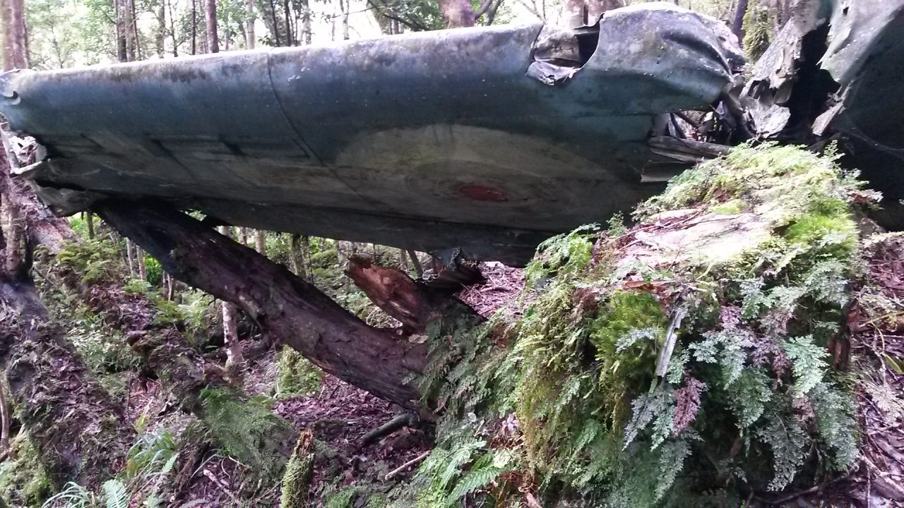


 As with other wrecks in the Tararuas there is debris spread across the forest floor, mouldering into the humus and merging with the trees and undergrowth. A section of broken engine block testifies to the force of the impact. With a bit more time I'm sure there would be plenty more to find but this is not the purpose of the trip.


This seems to be as far as a lot of people go as the track from here up is a lot less traveled. 20 minutes later at the ridge a plastic plane and markers indicate the top of the spur. 

It's about now that I am most regretting the location of my compass. Although it should be straightforward, the trail is often indistinct and the ridge top very broad and flat in places. The sun periodically sneaks through a gap in the high canopy and my shadow provides sufficient indication of direction to keep things ticking along. I am conscious though that I need to find the top of one spur heading west off a very broad ridge top. The forest is mixed but there is some beautiful sections of tall trees above a mossy floor. And lots of fallen branches to work around.

As it turns out, I blunder into some ribbon markers and a foot trail - I'm thinking that it is heading towards Tangata Maunga and a marked clearing (which would be good to find) but getting suspicious I check the compass and discover that it has veered west - and in fact turns out to lead to and down the very spur I'm after.

The map shows a marked 4WD track starting not too far down the spur so I enjoy the last moments descending through bush on the sharp spur. Fresh footprints indicate that someones have descended before me today - and pretty soon, quad prints indicate that they didn't make it up here under their own steam.

Things speed up markedly at this point but I keep map in one hand as I trot down, almost passing the 4WD track that dives down through a tunnel of trees to Waitohu lodge - a private hut with a rather stunning view.  The quad has been here too. 2pm - time for a drink and a bite.


Waitohu Lodge

The view


Spot-height 495 is a little off the main track so I follow the quad tracks when they take a left turn - more foot prints indicate that someone and their dog left the quad to head down almost as far as 495. I assume after pigs because there's not much else to see. Back on the trail I pick up pt 533 then pop off track over three lumps to make sure I have picked up 477.

Old boiler

The final point that I want to visit has a name - Ringawhati. It turns out to be on the edge of farm land with a rather splendid vista. In deference to the thought that this might be named after someone's Tupuna I don't sit on the point itself - and wonder idly whether the evidence that a cow had done more than sit there was more or less disrespectful.

A quick internet search determines that Ringawhati could mean broken arm or gay man (possibly a more recent reference to a limp wrist?), but more interestingly throws up references from the Otaki Maori land court from 1874.  It seems to relate to a block of land and clearly is a long standing local name.


Ringawhati


Back on the road I follow the quad tracks down the hill confident that if the quad could get through then so can I. At the bottom the ute is gone - the paradise ducks are still there and kick up their racket as I trudge along the road with a lone kotare leading the way. 4.30 at the car.


Postscript

As per yesterday's trip - this isn't my favourite haunt in the Tararuas. However it is fun to kick around and the bomber adds some interest. Stumbling over old logging trails gives some idea about the previous use of the land and you could spend days just following to see where they lead. I'm pleased to be able to say I have some passing familiarity with the area now but I don't think I will be back anytime soon.

Friday, 14 October 2016

Levin to Otaki with dry feet

There is nothing quite like the pleasure of perusing a map, identifying unexplored corners and promising trips to be stored away for future reference. In my case, added to a list on my cell phone to be ticked off over time.

One such potential adventure was the result of idle speculation about a chunk of land in the western Tararuas with the most intriguing possibility being to follow the winding ridge lines from behind Levin to Otaki forks without dropping into any stream catchments in between.

It was somewhat beyond my meager navigational capabilities at the time but with a few trips under the belt and having nibbled at the edges of the route a few weeks back (link) it felt like it was worth a crack.

What:    Below bushline navigation trip along winding ridge lines
Where:  Poads Road Levin to Otaki Forks
Why:     Challenging navigation exercise under a bit of time pressure
Who:     Solo
When:   Friday evening 14 October 2016 to Sunday 16th
Map:      Link

To get a good head start I negotiate a drop off on Friday after work, with the intention of getting to Waiopehu hut for the night.

Tramp
A few chickens are moping about the car park as my ever patient support crew drops me off under lowering skies.

Rain is threatening and it's a bit cold, so I'm well dressed as I head out a little after 5.20pm. My route coincides with Te Araroa: crossing farmland to climb into the range via the Waiopehu Track.

The sun occasionally manages to slant in under the cloud and the going is pretty good, albeit on a fairly sodden track.  About 7.45 I'm at the clearing just past the old hut site and it's getting dark.

The bush is quite wet so I'm pretty soggy arriving at the hut in the dark with the lights of Levin hidden in the clouds. It's 8pm and has just passed the point where a head torch is necessary.

Mercifully the hut is empty, providing the opportunity to run through a few pieces of music I need to know my way around. I've been roped into an impromptu family choir for an aunt's birthday as the token representative of the less musically endowed corner of the gene pool. Okay, a bit weird but there's nobody to hear and the acoustics are good.


Momentary sun on Waiopehu Track

It's a quiet night and I've had a pretty good sleep when it comes to pulling on damp gear next morning. A brief gap in the clouds reveals a dusting of snow along the main range to the east but the cloud soon closes again.

Morning view from Waiopehu Hut


Waiopehu Hut

Around 7.15am it's a short climb from the hut to the top of the hill where I look for hints of a ground trail leading to Oriwa Ridge. This ridge is a major feature running south and west from Waiopehu and seems to be reasonably well traveled, although not officially tracked.  

There's a bit of a trace to follow down through the tussock off Waiopehu into the bush and sporadic tape markers. The trail itself is easy to lose amidst the ubiquitous game trails, and the ridge is fairly broad, so it is easy to wander. However, following a compass bearing sees me pottering along and eventually into the clearing below Oriwa around 8.45am.

There's snow in the air and I'm pretty wet. The clearing boasts a small roof, collecting water into a barrel, and people have stashed bivvy materials in the surrounding bush.  I make the mistake of trying to follow the clearing, which pretty quickly becomes a scrubby bog. Back under the shelter of the trees the going is much easier.


Water catchment - and a wee bit of snow

Oriwa marks where my route departs from the main ridge. I can't see any clues as to a route and there are a couple of possible spurs. I select one, take a bearing, and head down.  The saddle to the west of Oriwa is pretty broad so it's just a question of finding the path of least resistance. 

In the saddle there is a small stream then a bush bash up the hill to the ridge above 918m. I don't find any evidence of a track in the saddle, but towards the top a bit of a trail develops. On the ridge there is something to follow northwest, and even an occasional old marker.

The ridge system here is somewhat convoluted with some boggy patches to negotiate. Under the canopy and in the cloud it is easy to drift off line, so it's better to trust the compass then my sense of direction. In the end it's pretty straight forward getting on to the ridge to 955m and the ground trail is stronger, suggesting that a few people come through here on the way to Panatawaewae to the north.

Near the top of 955m there is apparently an old crashed aircraft. I find the location and cast about in the bush but don't find it - I haven't paid particular attention to the description of the site and although there was a prominent marker on a tree I didn't want to waste any more time. I take a bearing and find markers taking me in the direction of Waitewaewae.

It's quicker than expected through this section, given that there had been more traffic through, so I truck on to Waitewaewae.  Which is where things go a little astray.  In retrospect I was over-relying on the markers - I noted one that indicated a direction of travel that corresponded with my compass bearing and confirmation bias took over. Unfortunately I hadn't traveled quite far enough, so the spur I started down was heading in the right direction, and at a similar steepness to the real route, but soon dropped into a stream gully through steep, rotting bush. A gap in the canopy revealed a ridge to the north where I should have been. By now the quickest way out was to bash through a couple of stream gullies and up the steep side of the ridge. 

It's tough going and by the time I'm back on route well over an hour has been wasted in some fairly challenging terrain. A bit of a sit down and a bite is in order. Still, at least the weather has eased up - cold but not raining. I'm a bit more careful about navigating down the rest of the ridge - at one point a spur heads north and down and there are indications that a bit of traffic goes that way - possibly an exit via the old mill site on the Waikawa Stream.

Following the compass I don't have any problems getting on to the ridge running south from 730m. At one point there is suddenly an old but well formed 4WD track which I follow briefly, before it dives right and down, while I follow my compass south.

It's pretty good going now and my route suddenly comes across the marked track to Mick. The pace increases but evidently my attention declines as I meet some markers heading in an unexpected direction. After a deep breath and a sit down I realise that I've almost done a 180 - probably around a bit of a knob (which is precisely what I am feeling like). A bit of a talking-to and I continue in the correct direction with a little more care.

This is now territory I have traversed in the opposite direction but I have no illusions about the chances of drifting off route. Soon enough I pop out into the clearing below Tangata Maunga. The late afternoon sun is streaming across the ridge. It's cold but the open horizon and view out to sea is refreshing after a day under canopy and cloud. I'm completely out of water so top up at the tarn (it's been so wet recently I figure it must be pretty clean). 

The track through the scrub is reasonably easy to follow up to the small clearing with the trig.  From now on I'm on the look out for a spot to pitch the tent that is not too: exposed, wet, rooty, steep ... It's a very small tent so you'd think it would be easy. In the end I find a man-made clearing with a view and a only slightly sloping clump of grass, around 7.15pm.

Transferring self and dry gear into the small bush cocoon is challenging at the best of times and it is far easier to do it without rain. It's still light but I've been on the go for 12 hours now so I stash wet gear outside, crawl into my pit, pull on dry clothes and start chewing on something for dinner while I wait for my feet to thaw out. Progress for the day was not too bad despite getting ... mislaid.  I'm looking forward to a more relaxed day tomorrow.


Inside the Macpac bush cocoon

Last of the light

It's a quiet night, I get a bit of condensation dampness on the outside of my bag and discover my site is a little more sloped then I thought, but it's all good.

Next morning there is a little bit of cloud about but the sun is breaking through over the main range giving a cheerful prospect to the day. I'm looking forward to a wander down ridge with little time pressure. There's even cell phone reception so I call in my intentions, before heading out around 8.15am.


Packed and ready to go

There is some very good marking of the route on parts of the ridge but this is a two-edged sword. At one point the markers assertively head off down a spur which I gradually realise is not the main ridge. There are a few points where compass and map are required and it's often not immediately apparent how to stay on the main ridge.

At one point, within the space of a few minutes, I frighten first a family of black piglets that explode squealing off the ridge edge, then a family of white/grey piglets that follow suit. At this point I'm always a bit nervous about running into a cantankerous mother pig.

A little below 400m and at 12 noon, the trail breaks out on to grass land and the view across to the slip on the Otaki Forks access road. Based on the map I should be able to follow grassland down to my right, to a couple of terraces above the river separated by a spur.


View to the slip with the forks road running across it

Map and reality diverge somewhat: there's plenty of scrub, steep banks, streams and bushlawyer. After two trips I still haven't found the best route through the bottom section of this ridge. It takes a bit over 20 minutes to drop down to the grassy flat, then a nasty struggle through horrible scrub around the spur that separates the terraces. A steep erosion gully that plummets into the river forces a scramble up and away on rotten ground through disintegrating vegetation. Fortunately this puts me onto a lovely benched track somewhat above the level of the terrace - tip for anyone looking to travel through.

The trail joins the two terraces and part way along I note some pink tape and a trail heading up - this may be the best route up the ridge (certainly more promising then what I've just been through).  The second terrace has a bit of swamp on it, so I head to the edge above the river and follow it around to the scarp above the Waitatapia Sstream.

It's odd to be so close to Otaki Forks but seeing it from a completely different angle. And knowing that there's still a bit of tramping to do to get there.

Edge of terrace looking towards Otaki Forks
Judd Ridge on horizon at left
I'm hoping to see some tape to indicate a way off the terrace as the map shows it's all pretty precipitous - no such luck.  There's a gap in the bush edge and some old cut branches at one point before the end of the terrace but the map says it is still on the edge of the scarp so I continue to the end where there seems to be a bit of something that might once have been a trail. It quickly degenerates into a precipitous scramble down through supplejack.

At the bottom the Waitatapia Stream is up but easy going. I've heard there is an option to cross the Otaki River near here but I've not done it before and there's been a bit of rain. I turn left and wade up-stream 300m to where I dropped off the opposite terrace a few weeks back. Some train wheels I hadn't noticed in the grass last time through mark the spot.

"What's that?"  
"It's a bogey man!"
The spur I went up last time -
my advice is: don't


The scramble up through bracken is steep but straight forward and I decide to see if there is an easier way across the terrace than last time. Some tape markers follow east along the top of the scarp which feels like a sensible way to avoid the boggy flats. On the way there's a good view down to the Waitatapia Stream and the spur I grovelled up last time.


A bit later a moldering sign indicates the old route to the bridge. Any semblance of a track quickly disappears into dense scrub so I follow my nose up through bracken (avoiding some healthy bushlawyer) to the Waitewaewae Track.


At this point in the trip there's always a bit of impatience for the end. The adventure has been had and the last stroll across grassy flats to the carpark can't be over quickly enough. This probably explains why I am a little short of forbearance for the couple that are blocking the swing-bridge with their dog while they take leisurely photographs. Eventually I get past and at 2pm number one support team rouses herself from her kindle in the sun to greet the slightly battered and scratched figure shambling into the carpark.

I think this one can be chalked up as a successful trip with a few more lessons learned the hard way - now it's off to River Cottage Cafe in Otaki for a late lunch.


Someones else have been out and about this weekend


Saturday, 10 September 2016

Waitatapia circumnavigation

One of the unexpected pleasures in life is discovering that you still have half a cup of coffee left that hasn't gone cold. This is akin to the feeling you get from the realisation on Wednesday that, for a change, there are no commitments in the weekend that prevent a sortie into the hills.  It leaves relatively little time to work out what and where, but I have a ridge in mind and something can surely be made to work.
_________________________________________________________________________________

What: Solo overnight tramp
Where: Waitatapia catchment in from Otaki forks
When: 10 September 2016
Why: Navigation practice, check out the ridge for a possible future trip,
trial new sleeping bag, check out detour on Waitewaewae track,
check out new road across gorge road slip.
Map: Link
_________________________________________________________________________________

The Waitatapia stream catchment lies near Otaki Forks and stands out on the map for its symmetry; laid out like a leaf blade pointing north. The ridge of interest is on the true right and runs north east then swings north passes through Tangata Maunga, past Mick and eventually onto Thompson. The reason I am interested is that I've figured that one day I should be able to join it up to Waiopehu. But not this weekend and not before I have a bit more navigation practice under the belt.

Usually when I find a spot that looks interesting on the map there are a number of trip reports to be found from various tramping clubs and invariably something useful from the Tararua Tramping Club. TTC have some almost useful material in Tararua Footprints (link) but not for what I have in mind. Other reports relate trips from Waitohu Quarry up to Mick and Tangata Maunga but nothing on the south end of the Tangata-Thompson Ridge.

Hopefully there isn't a good reason why people don't seem to frequent the area. I suspect most people that come into the Forks area are intent on stampeding up Judd Ridge to Field hut or along the Te Araroa route to Waitewaewae (YTYY).

Although my intention sheet describes the trip I think I might be doing, the plan is still not fully settled by the time I arrive at the Otaki gorge road slip and home command has been informed of two options. I park-up and look across the river to the ridge up: possibly a bit scrubby in places but should be doable.

Ideally I would cross the river at the bridge just short of the gorge road slip (marked on the map) and take one of the prominent spurs or grass clearings to the ridge but the bridge is not sign posted; I assume it is private so head to the Forks car park.

After a miserably cold week the weekend weather is for some showers on Saturday and improving on Sunday, not too bad. There is one ute in the park at 7.30 as I head for the Waitewaewae track in dull conditions. The owners of the ute are taking a break with their dogs at the swingbridge over the Otaki river before hunting the flats where I am heading. They aren't concerned that I might frighten anything off. Probably after pigs.

I wander across the somewhat soggy flats aiming to hit the Waitatapia stream somewhere with a prospect of climbing to the opposite ridge. There are a few bits of pink tape which lead me slightly unexpectedly to an old steam boiler with bogie wheels. I have heard this called saw mill flat and the track up to Waitewaewae follows an old bush tramway. This must have been quite industrious when they were hacking out the podocarp forests.

Sawmill flats

Same engine, Judd Ridge in the background

The 'track' dives off the edge of the terrace with a bit of a scramble down to the stream. Any thoughts of crossing with dry feet are soon dispelled, a bit annoying when it's the only water crossing for the day. I start up the 'spur' I've selected (BP33 890 735) and quickly find myself in amongst it: steep and covered in supplejack and kiekie. It's a bit of a struggle for a start but eventually it opens up a bit for a clamber up to the ridge. There's a bit of a ground trail on the ridge line so I suspect there is a better route up from lower down (possibly from the grassy terrace on the true right below the forks).

The ridgeline is generally pretty easy to follow and for a start the trail pops in and out of the bush with a few grassy tracts on the west side. Soon there is cell phone reception to confirm travel intentions and views across to the slip on the gorge road. The road marks a hairline fracture across the scarp and looks ridiculously vulnerable. Behind is the cleared forest of the spur where the bypass track runs.


Looking south to the terrace above Otaki Forks and Judd Ridge

Gorge Road slip

The ground trail is pretty good and Mr Pink-tape man has been through.  At either 655 or 650 (the latter I think), the ground trail splits and some pink tape leads off to the left, it doesn't feel right and I note that one is marked "Wallow Ridge" I assume this is the local (and fair) name for the main ridge and this is a marker for trappers coming up a spur. A quick back track and I'm on the right line again. There are a few other spots where map and compass are required but the ridge pretty much runs south-north so it's hard to miss.

Around 700m patches of snow appear on the mossy ground beneath the canopy, it gets thicker further up and is present to a greater or lesser extent until I eventually drop off the ridge to Waitewaewae. The wind is whooshing through the tree tops and I am regretting the wet boots from the stream crossing as toes (and fingers) become somewhat numb. 


A bit chilly

Just before Tangata Maunga there is a clearing (looking suspiciously like it was created with a chainsaw) giving a good reason to pause to look out to the coast and Kapiti Island basking in sun that has been conspicuously absent. Shortly after I duck into a low snowy tunnel through leatherwood before popping into a clearing with no view but a trig. Tangata Maunga - just over five hours from the car park.

The sun breaks through and apart from the snow on the ground it's almost summery.


View to Kapiti Island - a nice day out there!


View down - (another feet shot for Angela)

Tangata Maunga Trig - 912m


Leatherwood, Dracophyllum and trig with beech

There is quite a reasonable track through the scrub if you cast around which leads, in a bit over five minutes, to a weather station and view up to the next lump and my point of departure from the ridge: Mick.


Hydrology station just past Tangata Maunga

The route ducks back into the bush to drop gently then climb gently. When it starts dropping again I figure I must have just passed Mick, I'm about to stop to check compass and map when I pop into scrub and discover that I have already left the main ridge and am on course east around the top of the catchment.  About 2pm and time for a spot of lunch.


South down Waitatapia Stream catchment.
Tangata Maunga on right, heading for ridge on left. 
There is pretty much a track now, it clambers over a wee knob into bush again and past a well made bivvy site then back into scrub in thick snow. There are signs of scrub having been cut making the travel somewhat easier. To the east is mostly clag at about 1000m but with tantalising glimpses of beautifully snowy ridges.


Last sight of Kapiti - still in sun

The day is starting to get on a little and a bit of fatigue is setting in so time to get on with the slog through the snow. As the route swings south the track becomes a lot less pronounced, I wonder if hunters use this as a commuting route, pealing off to the Waitewaewae catchment at Island forks via spot height 872.

The ridge is quite easy to follow although the trail comes and goes. The only thing is to work out how far along the ridge I have traveled and which of the various knobs is next. I think I have it worked out but a break in the trees provides an opportunity to confirm by taking a bearing on Tangata Maunga.

At 875 pink tape appears again but heads off right, possibly an interesting route down into Waitatapia but not where I want to go. Shortly after the trail takes a marked left kink which means my departure spur is near. On the map it looks reasonably well formed and should take me down to a point where I can drop onto the track about a kilometer from the hut.

There are a couple of points where you can drift off the spur but it's generally good travel and easy to get back on again, in the end I pick a point and drop south off the spur and through increasingly gloomy bush down and down, keeping the sound of a stream to the right. Eventually it levels into a bit of a boggy patch and then suddenly; the track.  Whew.

The track surface is refreshingly solid and the surrounding trees don't break when you lean on them. A little of the weariness drains away but it's a fairly slow meander to the hut arriving just before 6.30 in the dark. All up a little under 11 hours from the forks.

The hut is empty so I hang up wet gear, have a bite and crawl in to my new sleeping bag (MacPac Epic 800). It is more than up to the task of warming up cold extremities. I'm sound asleep when a couple turn up after 9 but they are mercifully quiet so it's a great night's sleep.

The whistling trill of a warbler drifts into the hut as I lie in bed and watch a patch of sun creep along the skylight. For some reason the warbler has always been a sound associated with hot summer air and cicadas; this morning the air is decidedly cold and my bag is decidedly warm so its after 9:00 when I finally figure I wont wait any longer for the others to stir. I sneak out of the hut and pack in a wee corner of sun that is cruising across the deck.


Waitewaewae in the morning

Wet gear is never the nicest but the sun is starting to warm the air and soon enough I stop to shed layers.  The track is positively teeming with people (three); I run into a chap coming down Arapito stream - he says he camped on the way in and has left his tent to pick up after popping into the hut. The track ambles up the stream gully then levels on to the plateau for a pleasant wander through sunny bush. Just where the track used to plunge down Saddle Creek there is a large orange triangle pointing to the bypass track (about 1hr 25 from YTYY hut). I briefly consider the slope to the right which leads (eventually) up to the ridge I came down yesterday; it would be an interesting option to close the loop on another day.

Can't miss the bypass
Bottom end of the bypass
The bypass track doesn't have the solid base of an established track and there are lots of little roots and supplejack to trip the unwary - the sort of stuff that gets trodden down on an established track. It meanders along and up with occasional views across to my ridge of yesterday basking in bright sun. As it starts to drop I come across a bright orange tent pitched on a flat spot on the track smaller than a coffin. Poor bugger - if he'd traveled another 20 minutes there are some beautiful camping spots on the plateau. Another chap is coming in with a day pack and we exchange a few words to estimate our respective remaining travel times. The track is a bit rough in places with a spectacular tree fall to clamber through. It drops reasonably gently for quite a while and it takes a bit longer than I expect (a bit over an hour) to finally level out onto the original track on the tramway platform; lovely, wide and flat. The turn off is just as well marked as the top end.

It's plain sailing now just stopping for a few photos, say hello to another day walker and look at the view. Eventually the swingbridge over the deep waters flowing from the Otaki Gorge hoves into view for the second time in two days and it's a short jaunt across the terrace back to the carpark.

Waitatapia Stream - Otaki Forks and Sawmill Flat in the distance

Sawmill Flat - the target ridge running up to the right

Otaki River

About 3hr 20 after leaving the hut I sling my pack into the boot and leave a full carpark to head out along a busy road. Otaki Forks is back to its busy best and I'm quietly chuffed with a good we nav trip.