I have seldom had troubles with mosquitoes in the Tararuas so am somewhat affronted by the carnage the blighters have wrecked during the night. The itchiness is not helped by lack of sleep, courtesy of the chap playing late night music. Still, at least the rain didn't reach my sleeping bag.
In the predawn dark I pack up and head off to Otaki BP for breakfast and the start of day two.
What: Day two of two one-day navigation trips
Where: Back of Otaki - Waitohu Stream
When: 1 October 2017
Who: Solo
Why: Mopping up orphan spot-heights and ventura bomber
Map:
 |
| The day's ramblings - part of yesterday's at upper right |
One pie later it's light and I head to the quarry in the hills behind Otaki. The second gate is locked so I park the car on the road edge and (7:15) follow the road up valley (right across the bridge just past the quarry office).
A couple of kotare watch from the wires above and skip ahead a lamppost each time I get near. The quiet morning is disturbed by a pair of paradise ducks that honk and squeak respectively to warn of the interloper, then the harsh staccato rattle of a spur winged plover cruising into land in a nearby paddock ... not the most beautiful dawn chorus but familiar sounds to lift the boredom of the farmland.
I idly note a ute parked by the last bridge with ramps off the back - and slightly begrudge the fact that he must have had a key to the gate. My route lies directly ahead up a spur leading to Thompson. Almost the entire block of pines I am heading through has been clear felled - the activity has moved to the fringes of the block and there are no signs of movement today so I figure it's fine to traverse through.
The loggers have followed a tongue of pines all the way to the bush edge; about 400 vertical metres on logging tracks. The last part is churned up by log haulers so a little more porridgy, but overall easy climbing and an hour from the car.
 |
| From the bush edge |
From here up there is a ground trail through bush with sporadic pink tags as markers. At the top I emerge onto a wide, muddy trail with lots of foot prints. This is the trail I saw on Mt Thompson yesterday. There's a spot height at 639 so I squelch my way upwards.
The route down from 592 starts well with an old logging track heading in exactly the right direction of down that I am after. It deposits me on the marked logging trail down from Mt Thompson which is in very good nick (a fallen log indicates no 4WD access).
 |
| Ubiquitous logging trail |
When I drop off this trail to pt 395 it is to discover an older trail not far below - in not so good nick. The face below here doesn't really have any defined spurs so I just crash down through supplejack and rotten logs to emerge by the sizable but unnamed stream off Mt Thompson.
It's a little way to the mouth of the stream to pick up a track that behaves almost nothing like the one on the map. However I manage to find myself to the base of the spur I am after and the track does indeed follow up beside a side stream for a ways. A crude aeroplane shape made of markers on a tree just as the route dives upwards confirms I'm in the right place.
Once again I find myself plodding steadily upwards on an old logging trail. Rain occasionally hisses across the foliage far above but none quite makes it to the ground. A spot-height is marked to the right of the track around 600m. I drop off a little early but quickly find my way across to a long flat spur with a strong trail on it. It's 11.25 and another of the ubiquitous logging trails takes me back to the spur.
 |
| Pt 575 |
From accounts on the internet I've figured where the plane wreck is but it turns out to be a little higher than I was expecting - after 700m and once the spur starts a steep climb. I first notice a lot more markers then a piece of aircraft on a stump to the left of the track marks a further piece. Soon after, pink ribbons lead around the slope to the right and down to the iconic wing section of the plane.


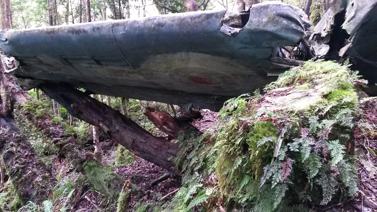


As with other wrecks in the Tararuas there is debris spread across the forest floor, mouldering into the humus and merging with the trees and undergrowth. A section of broken engine block testifies to the force of the impact. With a bit more time I'm sure there would be plenty more to find but this is not the purpose of the trip.

This seems to be as far as a lot of people go as the track from here up is a lot less traveled. 20 minutes later at the ridge a plastic plane and markers indicate the top of the spur.
It's about now that I am most regretting the location of my compass. Although it should be straightforward, the trail is often indistinct and the ridge top very broad and flat in places. The sun periodically sneaks through a gap in the high canopy and my shadow provides sufficient indication of direction to keep things ticking along. I am conscious though that I need to find the top of one spur heading west off a very broad ridge top. The forest is mixed but there is some beautiful sections of tall trees above a mossy floor. And lots of fallen branches to work around.
As it turns out, I blunder into some ribbon markers and a foot trail - I'm thinking that it is heading towards Tangata Maunga and a marked clearing (which would be good to find) but getting suspicious I check the compass and discover that it has veered west - and in fact turns out to lead to and down the very spur I'm after.
The map shows a marked 4WD track starting not too far down the spur so I enjoy the last moments descending through bush on the sharp spur. Fresh footprints indicate that someones have descended before me today - and pretty soon, quad prints indicate that they didn't make it up here under their own steam.
Things speed up markedly at this point but I keep map in one hand as I trot down, almost passing the 4WD track that dives down through a tunnel of trees to Waitohu lodge - a private hut with a rather stunning view. The quad has been here too. 2pm - time for a drink and a bite.
 |
| Waitohu Lodge |
 |
| The view |
Spot-height 495 is a little off the main track so I follow the quad tracks when they take a left turn - more foot prints indicate that someone and their dog left the quad to head down almost as far as 495. I assume after pigs because there's not much else to see. Back on the trail I pick up pt 533 then pop off track over three lumps to make sure I have picked up 477.
 |
| Old boiler |
The final point that I want to visit has a name - Ringawhati. It turns out to be on the edge of farm land with a rather splendid vista. In deference to the thought that this might be named after someone's Tupuna I don't sit on the point itself - and wonder idly whether the evidence that a cow had done more than sit there was more or less disrespectful.
A quick internet search determines that Ringawhati could mean broken arm or gay man (possibly a more recent reference to a limp wrist?), but more interestingly throws up references from the Otaki Maori land court from 1874. It seems to relate to a block of land and clearly is a long standing local name.
 |
| Ringawhati |

Back on the road I follow the quad tracks down the hill confident that if the quad could get through then so can I. At the bottom the ute is gone - the paradise ducks are still there and kick up their racket as I trudge along the road with a lone kotare leading the way. 4.30 at the car.

No comments :
Post a Comment