It's a longish drive from Collingwood up the Aorere Valley past the iconic Langford's store. We park at the Heaphy Road end with a small number of other cars - it's surprising there any given the bridge over the Heaphy River is still out. About 7.30am I say goodbye to the support crew and head down the wide track to Brown's Hut a few minutes away.
It's grey but not raining, and warm. There's a few residents just about to depart the hut but I don't stop to chat - just fill in the log and keep going.
There are a few brief views back down the Aorere Valley towards Collingwood, and just after 9am I reach the junction to Shakespeare Flats - my cue to leave the Heaphy and ease into the less refined byways.
Shakespeare Flats track sidles down the ridge. It's slumping in a few spots but fine. Near the bottom it jinks in the opposite direction to mine but looking at the density of the bush I figure it will be quicker to stick to the track. It flattens to follow a dry stream bed then drops to a sandy forest floor and a wee stream crossing near the river. The first impression of the Aorere is of large white rounded granite boulders and a good-sized river that will require respect.
I head up stream, building a feel for the river and the surrounding bush. The bush edge proves not so easy travel and reveals a pile of rubbish left at a hunter's' campsite.
After a km or so, there's a spot where the river comes close to the valley side. It's too steep to sidle so I doff trousers, don crocs and cross - it gets to nipple height but slow enough moving as to be no difficulty.
A little after 11, at the mouth of Flanagan Creek, it's time to cross back and get back into more suitable attire. The creek is a good size and travel is mixed - I alternate between the stream bed and trying to find routes through thickish bush. The ribs are a bit tender requiring care stepping up, but it's good to be underway.
I'm following a terrace above the stream that gradually disappears on me but having trouble finding a way back to the creek when I realise I've turned the corner out of the main valley towards my target spur (still Flannagan's Creek though). The creek gets steeper and more bouldery.
The junction at the bottom of my spur is obvious - and at 2pm it's high time for a lunch stop.
There were a few options to approach Mt Inaccessible. This spur looked steep but took the most direct approach. The top could be a bit gnarly and I'm hoping a strategic retreat won't be required.
Given the time, it is clear that I will be camping on the tops, if not the spur itself and, as there are no marked tarns any time soon on my route, I load up with 4L of water. The straps of the Torre creak under the weight and I lumber out of the stream and into the bush about 2.45pm.
There's no foot trail on the spur and it is unrelentingly steep. There are a few areas of tree fall and some rock outcrops that require a bit of scrambling. Higher up, cutty grass carpets the floor and provides good handholds (carefully grasped).
The (one) good thing about tree fall is that you get to see things that are normally way above your head. In this case an orchid - possibly Pekapeka (Dendrobium cunninghamii, or Ladies Slipper) - common but pretty.
The very occasional gap in the canopy reveals grey skies and the ridges around Mt Olympus.
As the day wears away, I start thinking about camping spots - nothing doing on the steep bit, so I'm going to need to get to where it levels around pt 1220. At the top (7.10pm) it's dense beech undergrowth but the ridge stays flat for a while so I keep travelling.
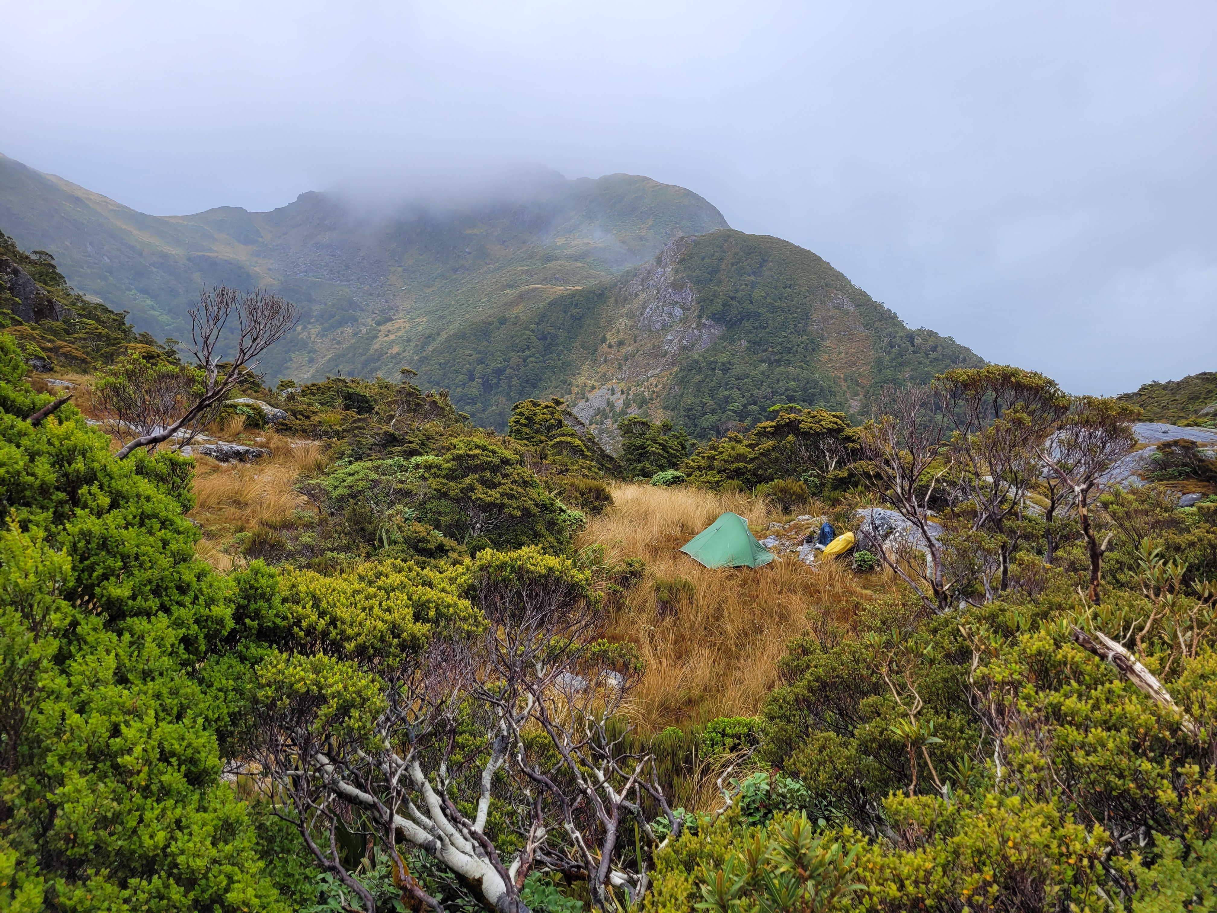
Perseverance is rewarded when I break into a series of mossy clearings providing perfect campsites. It's also open giving views up to Mt Inaccessible (sans clag) and into a beautiful basin below its east flank. Kea and weka calls drift up from below. Robins, tomtits, and korimako flick through the stunted trees on the ridge.
An armful of dracophyllum leaves provide a comfy base for the tent and I trial my new mix of dehy spud, mushroom cuppa soup, and dehy capers, olives and feta. It may sound weird but it's warm, filling and tasty.
As the evening dims, I sit in a clearing looking across the valleys with Saddle Creek and Perry Creek to Mt Perry. Somewhere below it is the Perry Hut where one of my options had me leaving the Heaphy to get to Mt Gouland via Kaka Saddle.
In the other direction there are various lumps on the horizon - some of which are probably the Douglas Range - home of the Dragon's Teeth.
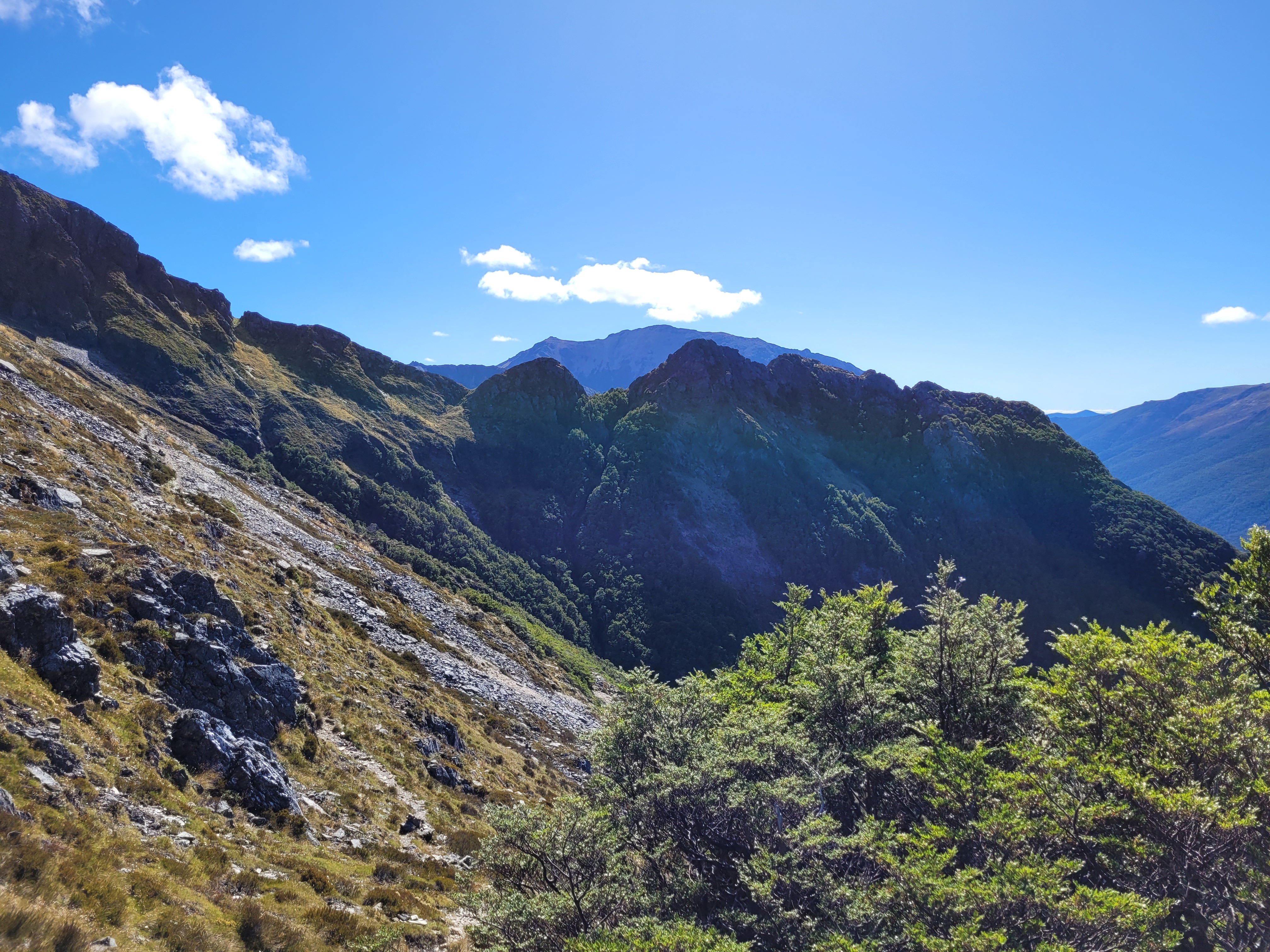
I study the ridge to the top in the morning light - it looks ok with a steep bit at the top as expected.
There's broken high cloud and patches of sun, but it's looking a bit ominous in the direction that the weather will be coming from.
A porridge brekky with the morning view and I'm off a little after 8am.
 |
| Mt Inaccessible and unnamed basin |
 |
| Imminent weather |
The route upwards is a mix of scrub and clearings with lots of chance to look at the view. Behind I can see my campsite and beyond it the point I joined the Aorere yesterday. The sky continues to darken.
 |
| Back to pt 1220, Aorere River to left |
There are a few tight scrubby bits and wee scrambles near the top but nothing too exposed. By the time I make the top, the clag is forming and breaking around the tops.
Shortly after 0930 I'm at the top. The nearby bits of ridge emerge and disappear but there's little else to see. I pop my nose over to the ridge SE to pt 1380 - looks a bit gnarly.
I make sure I get a selfie with the new compass as it's a gift from ex work colleagues.
The next section of ridge takes me west to Mt Gouland - I'm expecting that it will be a little more travelled as it's a logical approach from Kaka Saddle and the Gouland Range. The clag coyly reveals a wee saddle and craggy clamber to the next knob but nothing more.
The granite is weathering into coarse grains which create a crumbling surface on some rocks and is sort of grippy underfoot but also promises to roll if you hit it as too steep an angle. It's a little more scrambly than the last bit to the top but again within my comfort zone.
The ridge gets easier with more tussock, herb and shrubs appearing around the boulders. A couple of kea circle in to check me out but don't come too close.
My route follows the circ around the headwaters of Flanagan's Creek and below the unremarkable top of Mt Gouland. The cloud ceiling is fluctuating around 1300-1500 so there are views down and, most of the time, around the surrounding tops. I take a break just south of Mt Gouland and have a brief glimpse across Gouland Downs and down into Gouland Creek. Early plans had me camping on the open tops NW of Mt Gouland - they look like they will have viable spots and water not too far down slope.
At pt 1495 there's a good view southwest along the Gouland Range. It looks like reasonable travel (although could be scrubby) and it's tempting to change plans, but I continue to swing SE to head away from the range towards where I'll drop to the river.
 |
| Day 2 part 2 |
I've come far enough around now to have a view NE squarely back to Mt Inaccessible. It looks like a perfectly simple ridge from here.
The ridge to pt 1432 has a bit of scrub to negotiate and it's 1220 before I'm looking over the tarn beside my spur down. This was a candidate camping spot and it looks flat enough from up here, but possibly a bit boggy.
 |
| SE - Aorere Peak in distance on left (probably) |
 |
| Spur and Spey valley running away left to right |
I follow the spur into stunted beech and scrub and through a series of clearings, at the last of which I stop for lunch. There's no sign of trail on the spur and no obvious route down to the tarn but it's not far so would be a straightforward bash down if you wanted to camp.
It's okay travel on the spur once through the scrubby but I manage to drop SW a little soon and have to do some sidling. Below 800m the spur becomes indeterminate, so I pick the line of least resistance but keep getting drawn towards a steep and nasty gully choked with rotten logs. On the lower slopes there are patches of difficult vegetation - dense saplings and tangled growth. I find a pink ribbon and rat tunnel but no trails (they probably run along the slope).
Finally, at 3.45pm I can see the river through the trees but can't reach it yet. Travel in the bush isn't easy though, so I drop to the river as soon as I can.
The Spey River is very similar to the Aorere but smaller. It's mixed travel in the riverbed with boulder hoping periods in the water, but brief incursions into the bush generally don't provide great travel so I tend to return to the river.
 |
| Day 2 part 2 and bits of subsequent days |
A breathy whistle from ahead indicates that I've been rumbled by a pair of whio - they shuttle about in the water sounding their displeasure at my presence.
About 6pm I reach a junction with a stream coming in on the true left - I assume this is Taheke Stream, I've heard that this is a route to/from the tops.
 |
| Taheke Stream? |
I've been noticing the odd rock that looks like a lump of rusted iron in the riverbed, also the odd stream joining that has what looks like iron staining. No idea if these things are related or not.
 |
| Stumps from trees that have been overtaken by the river |
I'm getting a bit tired so start to look for campsites and it isn't long before a river flat turns up that looks established enough not to be at immediate risk of flooding. I'm pleased to find a nice flat and mossy spot for the second night out.
The camp weka duly turns up to keep an eye on proceedings and I turn in after dinner as a few spots of rain start.
Day Three - A Speyside terrace to Lake Aorere
There's a bit of rain in the night that's not too heavy, but I do have a damp tent to put away.
Getting away at around 8.15, the river doesn't seem to have noticed the rain, but the rocks are now slippery and somewhat slow travel.
In under an hour I reach another junction (Amohia Peak Stream?) and the Spey gets steeper and rockier. This is definitely getting into the headwaters of the river and the nature of the terrain changes.
Initially there is some travel in bush on the true left but soon I'm back in the riverbed climbing very carefully on snot covered rocks.
Just after 11am I come into a jumble of massive boulders. The stream flows in, around and below them somewhere. There's no easy way through apparent so I start clambering only to find dead ends, sudden drops, and unclimbable faces. I bear right (west) to where it looks like bush is taking over the boulder field where it gets even worse. The same problems but with tangled scrub and slippery humus thrown in. My ribs are giving me hell with all the pull ups and contortions required. I find I need to take a breath and bear down before doing anything that involves the core (i.e. any movement).
I extract myself from the regen bush to try my luck amidst the boulders again only to find that there is a large pool - slimy, deep and long. The only way through would be a long swim. I try to follow along the edge for a while - also no dice. Around 1200 I get to a wee stream amongst the regenerating bush without huge boulders - it's slimy and rocky but no big holes - for about 5 minutes. It deposits me into a death trap section - a deep, graveyard of rotting logs, a real leg breaker.
I manage to clamber around and past the pool without falling in only to find myself in a bog. It turns out to be not so bad - I can just keep out of the worst of it by duck walking at a careful pace and trying not to break through the grassy top. It's a relief when it finally gives way to a normal stream with a normal stony bed.
I suspect I missed an easier way through this part of the valley. The map shows slips on both sides of the valley that look like they fire house size boulders into the hell below. However, later in the trip I get a look down on this section - you can see the 'lake' on the right (true right). If I ever did this again I think I would try the true left side of the valley - i.e. as soon as you reach the big boulders coming upstream head west and follow near that valley wall.
The valley changes again as it steepens for the final climb to Lake Aorere. I briefly hook into the wrong stream (from Centre Mountain) before checking the compass and climbing in the bush on the true right of what we'll now call the lake outlet stream. It's okay going in the bush - keeping the roar of the stream close but not too close. It starts to steepen and I pop back to the stream to avoid getting caught in bluffs. This was probably a mistake, in retrospect I suspect the easier route is to stay in the bush on the true right all the way to the saddle. The true left will get you on the wrong side of the outlet stream at the top and it didn't look particularly easy to cross.
As for the outlet stream, it gets steeper and degenerates into a series of clambers on slippery boulders.
I'm being careful as every damp rock has a covering of visible or invisible slime. Near the top I have a few clambers with rocky fall out zones and have to use the walking pole straps to scrub the slime from each foothold.
At 1.10pm I reach the unequivocal end of the line.
There is no way forward and I'm not keen on down climbing what I just came up, so find a way out of the stream on the true right. I quickly find myself on gently shelving land leading through tussock and bush to a view of a sombre Lake Aorere surrounded by bluffs (1.25pm).
I'll be needing a campsite up here somewhere and the offerings near the outlet aren't immediately appealing. It doesn't look like there is a route to the other side of the lake that doesn't involve swimming, so I head left around the lake to look for better pickings in Aorere Saddle.
 |
| Lake edge towards Aorere Saddle |
I should have gone higher. The lake edge has tussock and scrub and a bit of wading. Near the saddle I head up through leatherwood, and other scrub and tussock. Stopping to get water where there is a wee trickle through the scrub. As I stand up I notice something orange on the ground - it's the bevel off my brand-new compass. It clips firmly back into place with the cardinal points lined up with the corresponding numbers, turns fine, and the needle is fully responsive - but I note the wee declination adjustment screw is missing and in this setting there is no point searching for it. The loss of this function is not an issue as I wasn't using it.
I'm a bit non-plussed. I've had Silva compasses develop bubbles and my old one has a wire clip in the base that tends to pop out - but that's after years of use and hanging around my neck on some fairly tough trips. A mechanical failure on a brand-new top of the line model is a bit left field - and I can't recall anything over the last two days that might have caused it.
It's not until I'm in the saddle proper that I start to see possible tent sites. There are lots of flat bits that are boggy but eventually I find a very nice wee spot with a springy moss base. With the tent up I run through the options.
I've allowed two nights here, including a climb to Mt Domett. But I just can't rustle the enthusiasm in the clag, wet through, a bit of chaff developing from the trou, and being a bit done in after this morning's efforts. Decision made I try to rig a line to drip dry a few bits of kit under the fly part of the tent (an act of pure futility - most of my gear remains in a soggy pile).
 |
| Camp site in the saddle at Lake Aorere |
The rest of the afternoon passes with sorting food, a snooze, squashing the odd sandfly, a few puzzles, then dinner before an early night.
Day Four - Lake Aorere to Roaring Lion?
The ribs have ensured a bit of an interrupted sleep; each time I wince awake, I drift off again to the sound of rain on nylon. I wake in the morning to more drizzle and clag. It may sound a bit dreary, but it is also waking to the satisfaction of getting to this point in this place and anticipation of what comes next.
I slap a couple of large plasters on the worst of the chaff and kit up - it's still not cold but two layers plus coat are required. Getting dressed, breakfasted and packing a soggy tent in the drizzle is a bit slow, so I'm away at 7.45.
Getting out of the saddle is a little tricky with some scrambling through scrub. There is then a clear walk up until a band of scrub appears - it looks impenetrable. On approach, however, I discover that is forest and reasonably open underneath. I work up close to the north edge of the ridge. Towards the top of the bush it gets rocky and I sidle and scramble up - it would probably have been easier to bear right on the way up and keep away from the edge.
It opens out for a bit but then dives into a band of scrub. This is hard going but I'm delighted when a loud chirp grabs my ear and a speckled brown bird with a slightly tatty tail emerges from the scrub a few metres away, checks me out and flits off. It's a
fern bird. I don't know much about them but thought they were lower land - didn't expect to see one at 1200m. I've heard
from an expert that there are lots on the West Coast if you know where to look and take the time to let them come to you. They have been described as skulking passerines - not very complementary and not particularly accurate as this one was bordering on the cheeky.
Above the scrub it's open travel with occasional low scrub and a bit of a foot trail - possibly goats but it helps on the steep climb. There are no bluffs or complicated scrambles.
It's a slow damp hour 50 to the top. Not cold but a bit of breeze so I tuck into the tussock off the top for a quick bite and take a compass bearing - checking the bevel is still lined up first.
 |
| Centre Mountain |
In the clag all directions are the same, so I follow the bearing until a spur starts to take shape and the faces drop more steeply on each side. It's always a bit of a relief as the expected landforms appear out of the murk.
I make way down the slope towards the saddle somewhere below. From the map I've picked a possible line down into the headwaters of the Roaring Lion River - just before the first wee lump marked on the map as you drop towards the saddle. The face of the basin below looks steep but there's a clearing marked that looks like it might be a goer - if it looks bad, I'll follow further into the saddle and investigate a couple of other options.
The ridge flattens and the clag breaks briefly - I can see down to a large grassy area with a boulder field running down through scrub. It looks doable so around 10am I leave the ridge to scramble down through large rocks and leatherwood.
It's steep and a bit of care is needed but I'm pleased to reach a narrow stretch of goblin forest before breaking onto a tussock flat by 1030.
 |
| The route down |
It's a pleasant amble across the flat - behind, the clag shrouds the ridge but it's clear down here. Water channels coalesce to form a wee stream which gurgles over the edge of the flats in a series of waterfalls.
 |
| The first roar of the lion? |
The water course drops steeply and it's a bit gnarly scrambling through the low hanging scrub or climbing down through the scrubby bush on either side.
About 11.15 it levels off a little and more grassy flats appear. Some with small inky black tarns - one of which has a wee island with a grassy hat.
The stream gets bigger and I'm fully occupied trying to find the best option between slippery rocks and increasingly deep pools or scrubby forest and grassy bogs. On the bright side, the drizzle is letting up and the clag is breaking.
Around 12.50 I'm ambling through pleasantly open forest by a, now quite large, stream meandering quietly along. A large grassy flat appears through the trees so I leave the stream and strike across. It turns out to be not quite the blessing it appears - the grass is shoulder high and conceals deep little channels and areas of knotted scrub - I'm committed though so make a slow way across to the distant forest edge - it takes 20 minutes.
Back in the forest I find a shaft of sunlight and sit in the moss for lunch. Hopefully the weather is breaking, although the forecast was not so positive.
A short while later I'm sidling in mature forest a little above the valley floor and break onto a wee dry stream course. I idly check the compass and can't make sense of the reading - I must have got myself turned around somehow. I sit on a rock to work things out but can't reconcile the compass and map in any sensible fashion so, getting lazy, whip out the Garmin app on my cellphone. The blue triangle eventually pops into view - a long way from where I expect it. A long, long way. A long way away, in a different valley, with a mountain in between. Spots of rain start to fall and I suddenly feel very alone.
My entire navigation practice is based on trusting my compass - but GPS's shouldn't lie either. The GPS is adamant that rather than heading northeast along the Roaring Lion I am heading southwestish down Domett Creek. I study the compass - the needle moves freely and settles quickly, and corresponds to north on the Inreach compass. The cardinal points on the bit of bezel that came loose still line up with the corresponding numbers on the graduation scale ... then I note that the Orienting Arrow (the red one on the base of the compass behind the needle) is not at zero on the declination scale. On closer inspection I discover that with a wet finger the Orienting Arrow can be shifted relative to the declination scale i.e. any bearing taken will point in a completely random direction.
It seems that with the adjuster screw gone, the declination scale can freewheel with a little encouragement. So, when I took the bearing at the top of Centre Mountain the compass pointed in a random direction that just happened to have a ridge sufficiently similar to the one expected - after that confirmation bias took over and everything fitted perfectly. In retrospect though there were a bunch of little things that I should have picked up (the vegetation on the face wasn't dense enough, the meadow was too flat, the stream dropped too fast ... ).
As well as feeling very alone I'm now feeling a bit stupid - the possibility of a compass malfunction hadn't entered my mind even though I had had to fix it.
I sit on my rock in the narrow creek bed and run through the options. First - there is no panic, I have plenty of food, a tent and I can use the Inreach to let home command know that I'm a little off course. I also have some redundancy in my navigation options: I can align the map to physical features (when I can see them), the Inreach can give me locations I can transfer to the map, and the cell phone has the GPS app. I also work out I can use the compass but just have to rotate the Orienting Arrow to zero on the declination scale every time I look at it.
Continuing down the Domett to the Ugly River leads to a likely flooded and completely impassable Karamea River. Scaling the valley wall to drop over into the Beautiful River looks temptingly possible but commits to a river that will likely be very large long before I could reach Roaring Lion Hut at the junction with the Karamea. Or I could climb to the ridge then follow it back to Centre Mountain - but if it turns out there are bluffs I can't get past I'll be a bit stuffed - besides, the map indicates a lot of scrub above me.
Backtracking is the only option, but rather than scaling back up the steep headwaters of the true left tributary from whence I came, I decide to take the more direct (shorter and less steep) route back to Aorere saddle. Decision made, I send a message to home command at 2.45pm and turn back up valley.
 |
| Day 4 ... |
I'm a bit rattled by the navigation error so enter the location of Aorere Saddle into the GPS and follow the track - carefully keeping to the forest edge away from the grassland.
Following the Inreach leads into steep scrubby country to the west of the saddle stream which I would likely have avoided if I was navigating by eye. However, it keeps me on line and I avoid the worst of the bluffs - it's just longer and more strenuous than necessary. The map shows that there is a clearing along the stream course which may be easier going (however, it also showed forest where I went, so go figure).
 |
| Tough country to bush bash |
About 6.15pm I break onto the open tussock and herb field beside the stream, as the slope eases towards the saddle. I plod upwards briefly pausing to top up with water before pitching my tent in the same place as last night.
After sending a check-in message I take stock, I'm just as wet as yesterday, the ribs are protesting at every movement, the chaff has developed magnificently - now covering from the, ahem, upper legs to the knees, plus of course the usual numerous wee cuts, scratches and bruises. On the bright side, I had allowed two nights at the lake so I'm still on schedule and there's plenty more adventure to be had.
I turn in to the sound of kea and weka.
Day Five - Lake Aorere to Roaring Lion!
 |
| Days 5 and 6 |
It rains through the night again but clears by morning and there's even some blue sky. I use the rest of the large plasters to line the aggrieved area before crawling out to face the day.
Yesterday was demoralising but some short freedom from clag gives a view up towards Centre Mountain and down to the lake, reviving flagging spirits.
 |
| Centre Mountain |
It's 7.50 before I get away - this time bypassing the scrubby bits in the saddle and heading up the middle of the foresty bit which proves easier than yesterday. I then try to sidle upwards on the south side to avoid the other scrubby bit - this turns into a tussock scramble with plenty of spaniard so not to be recommended. The clag is still broken so there are good views back to the lake, down the Domett Valley and into the Spey.
 |
| Mt Domett in cloud to the left |
 |
| Domett Valley |
The view into the Spey treats me to a reminder of the boulder field from two days ago.
 |
| Spey Valley |
The top of Centre Mountain is in clag again - I already have a photo of that. However, I do pause to take a bearing and double, then triple check the settings on the compass. Once again, a ridge of the expected form appears ahead and I follow it down. This time however I drop below the clag and I can see the saddle, the ridge to pt 1518, the headwaters of the Roaring Lion, back to Lake Aorere (I can almost see the outlet waterfall) and down into the Spey. I'd call that thoroughly triangulated.
 |
| The right saddle, Roaring Line on right |
 |
| Domett still in cloud on left |
It's a steepish descent requiring a bit of zigzagging and scrambling. The last scramble drops me into a narrow gut across the ridge, by my calculations at the foot of the first wee knob on the map. The clag comes in again but I know which river system I'm dropping into now. I head onto the slope which is fine at first but soon gets steep and ducks into slippery scrub and forest then into bluffs. I manage to find a way through though with some slightly hairy descents through slots slick with black humus. A bit of trial and error and I eventually find myself on pleasant tussock land descending easily to the valley floor.
Looking back at the ridge there looks like a far easier descent at the lowest point of the saddle. Don't go the way I did.
 |
| Low point in saddle at middle - a better descent option |
By 11.20am I'm on the valley floor next to a good size stream. It's much easier going than yesterday with the valley dropping steadily but often with reasonable travel through open scrub beside the stream. I startle a couple of deer at one point.
Soon it is easier to travel in the scrub and forest than in the stream bed and there are often open areas that are a bit boggy but allow reasonably good travel. I tend to be on the true left mainly so don't know if there are better options on the right.
The drizzle returns and soon the damp foliage has me as saturated as I have been for the last few days. I've been going reasonably well on the true left but it's getting a bit tight so I cross the stream to see what it's like - it's no better but I'm slightly stunned to break into a wee clear patch with a steel survey post in the ground (E 1547735, N 5455106). There's no spot height marked on the map and no apparent reason for it - it's the most weird chance that I stumbled on it. I continue down river switching back to the true left.
Around 1.30 I drop out beside the river to find a spot for lunch - it's too big and bouldery to follow the water course now, so I've been entirely in the bush for some time. The river is veering SE and I've just passed the stream off pt 1578, I'm pleased with progress as my plan has me camping in this valley before a climb tomorrow over Peel Range to Fenella hut.
It's a pleasant spot with the river roaring through a gap in some boulders into a dark pool. I don't know what colour it is normally but today it is a dark greenish brown and looks to be somewhat up. I sit for a while in the drizzle munching on crackers and peanut butter with a cup of orange and mango raro - quietly content.
Progress continues in similar vein after lunch until I get the impression that there are better terraces on the true right. I cross and just inside the bush edge find a track marked with pink ribbons. It must be a biodiversity trail and it must have had a lot of use over the years as it is good and solid. Progress speeds up considerably from this point. There is the odd spot where it crosses a stream and I lose it but each time I manage to find it again.
Around 3pm I stumble on evidence of its purpose. A trail cam, tracking tunnel and microphone are set up. As soon as I stop, the resident robin turns up to say hello and I rather fear some DOC worker will have to listen to a recording of the high pitched drivel I direct to the robin.
I'm thinking that where there is a track there might be a hut and I'm also crossing my fingers that the trail runs a good way down river. It wafts me along through open forest, grassy terraces, bogs and across streams for at least 2 km before dropping me into a large grassy clearing - at about 3.25.
The first thing I note is a weka making the strangest distress call I've heard - it walks away when I approach and seems uninjured but soon returns and keeps up the squawking. It doesn't seem injured but I wonder if it has lost a chick or its mate. The next thing is a pile of old firewood and stumps in the ground where a structure used to stand. So much for an early night in dry quarters.
I cast around and find a bit of a foot trail leading downstream from the clearing, but I soon lose it and don't find any more signs. I continue down the true right until around 5pm I came onto a large rock fall. It's a mix of old and fresh rock and I make a way across, but quickly realise that it gets a bit bluffy down stream and the river is starting to get boisterous. I backtrack and drop to find a crossing point and a stick.
There's a lot of energy in the river but I get across comfortably and toss my stick into the water - this is the side I want to be on and I don't fancy crossing twice more. The next time I pop out on the river bank I'm pleased I'm on the left side, there are slots, pools and cascades that I don't fancy navigating.
It's not 6pm yet but I'm getting close to the stream from Island Lake where I'll be leaving the Roaring Lion - the best bet for a campsite is going to be near the river so I keep an eye out for suitable spots - nada. Until the ground suddenly levels out and I stumble onto a delightful flat mossy area with a wee stream near by. It is unbelievably perfect - some scorched rocks indicate others have thought so too.
I pitch the soggy tent and head to where I can hear the river to get some sky and satellite cover. At the bank I am somewhat disconcerted to discover that the water is flowing in the wrong direction. It takes a few moments to realise that this is the side stream from the Island Lake catchment and it is very large. 50m down stream it joins the Roaring Lion.
It takes almost an hour sitting on a rock in the middle of the 'stream' before the Inreach grudgingly confirms that it has sent my check-in message. Even then it fails to establish a location fix. I assume the narrow valley and high canopy are a bit much to get a signal through.
Back at the tent I cook dinner then hang sopping gear on a tree to stay soggy over night. I briefly toy with lighting a fire but there is little point trying to dry anything in these conditions and I'll be warm soon in my sleeping bag.
Everything feels damp now despite best efforts. I lie listening to the drips and weighing the pros and cons of tomorrow's options - I had intended to follow the stream up to pt 1590 then around the circ of peaks to Aorere then Gibbs and Xenicus - but having seen the size of the stream I'm not so keen on the prospect of there being good travel on the banks in the lower part of the valley.
I had seen a reference online to someone descending the spur on the other side of the stream - from pt 1352 coming down the spur towards pt 956 then angling west to keep away from the steepest bits to emerge near this stream. The map shows it's possible with a lot of room on the face to go around any obstacles. This would give me the most direct route to Cobb Lake and Fenella hut.
So, I have options and am on schedule with time up the sleeve - the weather should also be lifting in the next day or so but I'm not that keen on a long day climbing a bunch of peaks with no views. The clincher is the thought of arriving at the first hut for the trip with time to get kit dry and have a good rest.
Decision made I roll on to the least tender side and drift off to the thud of heavy drops landing on the tent from the distant canopy.
Day Six - Roaring Lion to Fenella Hut
It's not actually raining in the morning, which is nice, although there's plenty of water making its way down from the trees so it may as well be. There's a clearing across the stream which should have a better view of the sky so after breakfast and packing, I carefully navigate the stream and settle down to send the plan change.
 |
| Clearing on true left of Island Lake Stream |
It takes a while to get a signal again, so it's after 8.30 before I head into the dripping forest and start up hill. The lower levels have a few scrambles and lots of slippery humus and moss but overall, it's a straightforward climb. A group of kaka racket around overhead at one point.
The only point of note is seeing an orange marker on a tree with another further up slope. It feels completely random to come across something like this in the middle of an unremarkable hillside - until I realise it probably is exactly that. It's marked as a 'recce' line and was set up almost 37 years ago. It is probably a transect line that might have been started at a randomly selected point. It gives a point of focus so I follow it up the steep slope. I idly wonder if any of the survey team still work for DOC.
Further up there's a bit of tree fall, and I start following a steep spur - the trees get thinner and the canopy lower but the orange markers continue. It's interesting to see that some are attached to quite slender trees - they must be quite slow growing given they had to have been big enough to nail into 37 years ago.
It hasn't rained all morning and the forest has dried considerably when I eventually reach pt 1352 at 11.50. It's not been a technical climb but it's been an effort to lug myself and pack up - over three and a half hours. There's a bit of foot trail along the ridge and a post to mark pt 1352, also a plastic bottle which I stash in my pack.
The ridge is mossy and dry with a low canopy, there are also lots of windows out across the Tasman Mountains and occasionally down the Roaring Lion Valley. The ridge is blessedly flat then climbs before leveling again. Below to the right are two lakes in a basin with an unnamed point on the Peel Range above. I'm quite happy to stop regularly to take it all in.
 |
| Down the Roaring Lion |
The bushline at 1400m means uninterrupted views and easy travel, circling above the two wee lakes - the top one complete with a tiny island. It's still overcast but warm enough for the last steep climb to pt 1574.
At 1.10pm I'm sitting just over the top tucking into lunch and looking down on Lake Cobb. To the SE a very genteel ridge runs along to Mt Cobb.
 |
| Cobb Lake - Snowdon on horizon to left |
 |
| Peel Range towards Mt Cobb |
It's an easy amble down into the basin with Round Lake appearing from behind a wee spur. The upper slope is steep but today the short grass is dry and quite grippy underfoot. I think it's snow grass or carpet grass of some description (Chionochloa australis?). Lower in the basin yellow Bulbinella flowers are scattered through the tussock - and lower still stalks of flax promise food for any nectar eaters that come up from the forest below.
There are also plenty of mountain daisies - I note that they often have a wee hover fly or similar parked on the yellow centre. They just seem to be chilling - not actually feeding or anything.
 |
| Round Lake |
The line of the track on the other side of the outlet gives something to aim for. In the odd spot the tussock and scrub get to knee height but there are a few trails to be found and they start to coalesce closer to the lake.
Around 2pm the start of the trail from Round Lake has a few wee cairns at first but soon the muddy trail is easy to follow and dives steeply out of the basin into the bush with official orange triangles. The track is slippery and feels about as risky as much of the off track I've been doing.
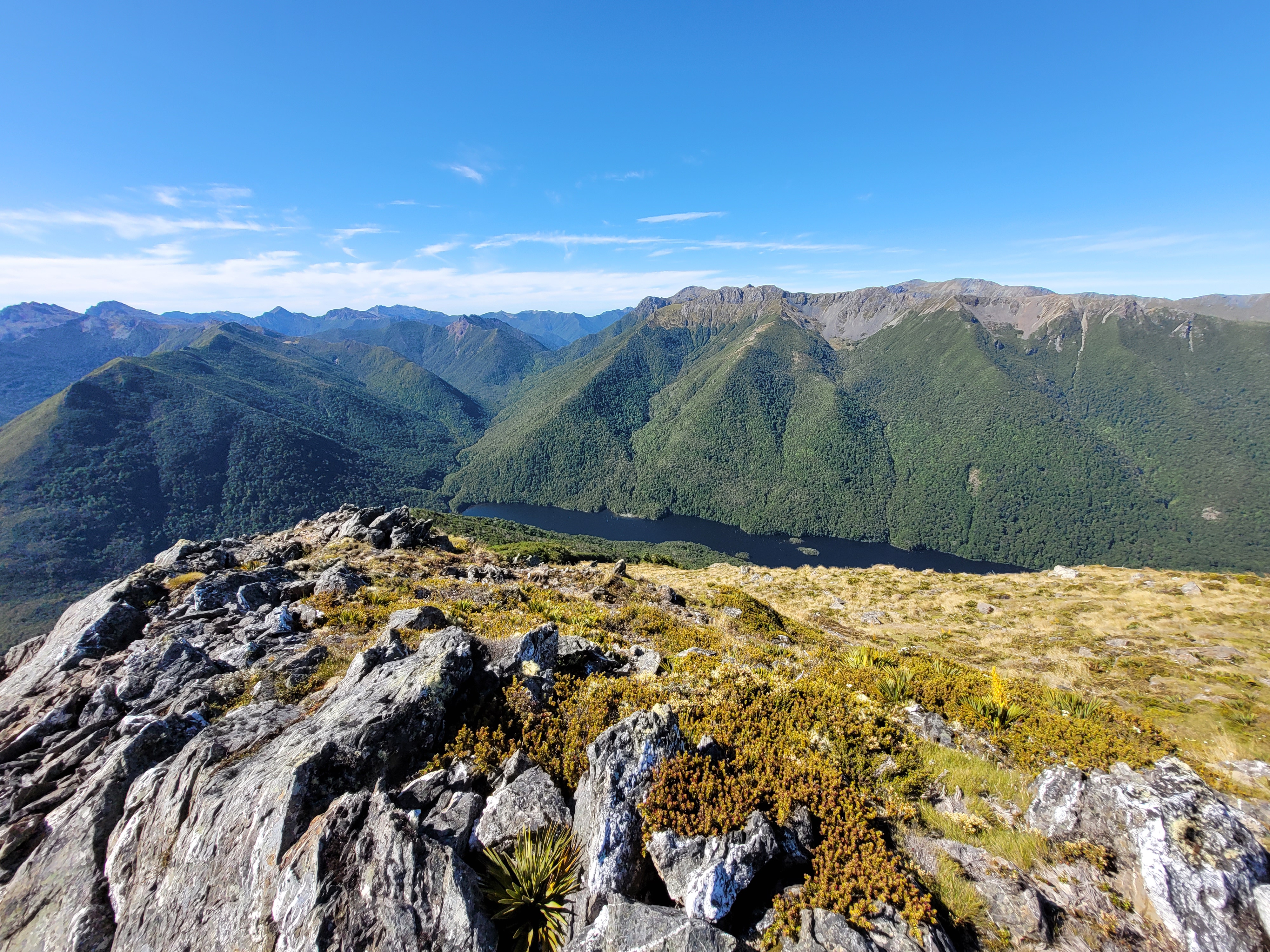
Half an hour later the track spits me out at the head of Lake Cobb - the lake level is up and the path around the edge mostly underwater so I squelch along until I find a track in the bush edge. Across the water the bluffs of Xenicus Peak drop slowly behind.
 |
| Looking back up Lake Cobb, Xenicus on right |
At the outlet (just before 3pm), rather than follow the track down to the historic Cobb Hut then up to Fenella, I take the track pointing up to Xenicus Peak on the premise that there is bound to be a trail leading to Fenella. The track climbs to just short of pt 1186 then splits - I take the right branch which leads through rocky outcrops and a series of tarns above Fenella Hut.
 |
| Down the Cobb Valley |
 |
| Fenella Hut below - Waingaro above |
 |
| Erratic tarn |
 |
| Another tarn with Xenicus behind |
The track wanders around a bit and I manage to lose it when I head off to explore. In the end I bash down through bush to the grassy clearing near the hut - about 3.45pm.
There are a couple of parties in the hut already - a local family of four and an older American couple with their son who is working locally - good on them for travelling around the world to go tramping with their son - possibly a bit of a culture shock.
During the course of the afternoon the clouds have started to break and I'm able to spread wet kit to dry and wash the smelliest items - including myself. A couple more blokes turn up but take one look at the 8 bodies already in situ and head off to pitch tents elsewhere.
I spend the afternoon watching over the drying process (only one weka in evidence but that's more than enough) and chatting to the other guests. The many luxuries of the hut (gas, running water, space ... ) make life easy. I'm tickled to find a wee mistletoe growing out of a tree behind the hut about a metre off the ground.
Of the couple with kids - she is a keen tramper, but he isn't. I suspect there is a wee bit of tension generated by choosing a family activity that suits one more than the other but hopefully he's got some enjoyment from what is a beautiful setting.
As expected, the night is a bit noisier than the last few but that's what ear plugs are for.
Day Seven - Fenella Hut to Soper Tent Camp
Fenella is an assessment point - push on with the plan to exit to Takaka via Mt Snowdon and the Anatoki or bail down the Cobb and hitch out. The morale boost of a short day, improving weather, and getting clean and dry is immeasurable - and the blue-sky sunny morning makes the decision easy.
 |
| Day 7 |
It's after 9am before I get away. The others are all heading down the Cobb and are in no hurry.
About 40 minutes later I'm on the Lockett Range below Waingaro looking for where the Douglas Range track starts (ignore the false trails that set off from the saddle, you head up hill a short distance and it's pretty obvious). The two late arrivals from last night catch-up. A young local lad with a slightly older English chap, they're not carrying anything - just taking a look around and probably scrambling up Waingaro.
The route today follows the Douglas Range (Dragons Teeth) route to Kākāpō peak where I'll split off for Mt Snowdon. The first part is a lovely long sidle across the SE face of Waingaro, to a notch on the spur from pt 1550.
The track climbs into the notch and at 10am I have a lovely framed view across to Mt Snowdon 5-6km away. It's flanks are light coloured from the scree slopes I will no doubt be climbing in due course.
Another long sidle leads back to the ridge as it drops to the saddle before Kākāpō Peak (10.55am).
 |
| Mt Snowdon on horizon |
I leave the track to follow a trail up the SW ridge of Kākāpō peak. Below is the spot I did my knee in last time and the scree slope with the thread like line where the Dragons Teeth track crosses.
It's steep but there are no challenges getting to first the false peak and then the top just after noon - about three hours from the hut. There are rocky outcrops on the way up but it is mostly about picking a way up through shattered scree.
The views from the top are magnificent with the Dragon's Teeth a dramatic feature in the middle distance.
It's warm and calm and time for lunch. I also take the chance to lay out a couple of bits of kit that didn't completely dry over night. Sitting there in the sun with that view and a cup of raro - I spin it out for well over half an hour.
I don't know what to expect for the ridge ahead. The map indicates it has a bit of down and up but it doesn't look particularly remarkable. I rapidly discover that there are a series of rocky knobs that I don't fancy climbing. I drop down the north face of the ridge and sidle below them but find that I have to go a ways down to do so. The slopes are not too bad with lots of short carpet grass but also liberal quantities of spaniard that shed leaves that slip underfoot as well as drawing blood from an unwary hand or leg.
It would be tricky and in some places a bit risky travel in the wet - if you slipped you would rapidly accelerate on the carpet grass and self-arrest could be difficult. I carry my walking poles ready to dig in. After pt 1720 there is an interesting basin to the north with tarns that looks accessible and could be a camp site prospect.
 |
| Back up the ridge |
 |
| Another knob sidled |
From the saddle I switch to the south side of the ridge to cross some scree slopes on the way to pt 1681 - about 1.20pm I think.
 |
| Back towards Kākāpō |
After this it's back to the ridge to scramble over and around rocky knobs. It feels a bit exposed in places and the rock is shattered and loose.
The rest of the travel along the ridge varies from ambling on grass, to steep rocky scrambles. I see one other wee tarn that might be a camping prospect but possibly will dry up later in summer.
I have a good long stop in the shade of the bush in the saddle before pt 1577 then tackle the last bit of ridge. More knobs and scrambles.
Something catches under my left foot on a sidle around a knob and I'm a bit alarmed to discover that a flap of the sole of my boot is ripping away exposing bits that shouldn't see the light of day. The tread is still ok and I can walk fine but if this deteriorates further it could get interesting.
Around 3.10pm the alien queen rock marks the end of the ridge section and the start of the steep climb up scree towards pt 1793. To the left is the spur I plan to descend.
The walking poles are worth their weight - it's not technical, just a question of picking lines that don't have you sliding back too far with each step and grunting your way up. The odd pause is useful for studying the ridge I intend to take down to Lake Stanley. It looks ok from here.
 |
| Ridge to Kākāpō |
I drop my pack just past pt 1793 (no keas seen today) and pick a way up through more boulders and scree for the top. It's about 4.15pm when I reach the wee white trig on the broad top and stop to look around.
At 1859m Snowdon is the second highest peak in the park (to Mt Owen). You can imagine the views - the lumps on the horizon look tiny but having clambered over just a few of them in recent days, it is breathtaking to take in the sheer expanse of real-estate to explore in every direction.
The ridge I came along runs into the distance to Mt Kākāpō - probably only 5km as the kea flies but it's taken around 3hr 40 and feels like a hard, hot day.
I take the chance to check out my soles and discover that the other one has also given way.
With an eye on the time I don't linger and return to my (unmolested) pack, noting on the way that from this angle the east face of my next ridge and some of the knobs look a bit unfriendly.
From pt 1793 I pick a line that drops down the west face below the ridge line and into a wee channel that drops me from the rocky tops into tussock, spaniard and carpet grass. It's quite steep in places requiring care with footing but I maintain a line below the ridgeline until rejoining it at about 1550m.
It might be okay on the ridge line but it looked like there would be some climbing. I opted for lots of sidling which is hard going - steep and lots of spaniard. In wet or snow you would want to be very careful.
 |
| Route from pt 1793 |
About 5.15pm the ridge eases and there's a boulder pile where I can get a look at the bushline and the spur I've chosen to get down to Lake Stanley. There's still over 700 vertical metres to drop. It's also the last look I'll get at the top of Snowdon - across the basin and just out of sight over a spur there's a massive slip face where the hillside dropped into the valley during the Murchison earthquake (1929), creating Lake Stanley. Across the Stanley Valley is a range with the Devil Range behind - this range bends north then east as the Anatoki Range.
At the head of Lake Stanley is a) the tent camp I'm aiming for tonight and b) the track that heads up the Stanley River to drop over a saddle into the Anatoki River.
The spur is wide and there's no discernable trail. I was hoping that it was an obvious route to Snowdon from Soper Tent Camp but not so. The vegetation is a bit mixed - quite a bit of undergrowth in places but mostly just annoying rather than problematic. A couple of rock outcrops in the bush require a bit of a side step. One near the bottom is just about hidden in dense saplings - I'm pushing through and suddenly realise I'm looking down on the tops of trees, a hasty step back and it's not long to find a way around and down.
 |
| More mistletoe |
The slope eases and I pop out on the track around 6.40pm. A few minutes later is the turn off for the hut which sits on a wee spur above one of the two Stanley Rivers that flow into the lake. Popping down to the stream I can see the evening sun on some drowned trees at the top of the lake.
Tent Camp looks perfect for the night - partly because it's utterly charming, partly because it's empty and partly because it's not damp nylon six inches from my nose.
As soon as I arrive the resident robin turns up and hops a full circle around me about a foot away. Curiosity assuaged it stakes its claim by driving off a tomtit that has the temerity to take an interest.
Despite it's looks, it was actually built in 2016 in honour of Frank and Berna Soper - a local Golden Bay farming couple who founded the local alpine club and lead the construction of a number of key huts in the area - as well as advocating for creating the park to protect its values. There's a story on the wall and even a book of Frank's poetry that has survived in good order.
Inside, there's a dining/sitting area and a wee sleeping alcove at the park with two mattresses (plus a third on a bench in the main area). The alcove is a tent within a tent. It's all very rustic but seems to be weather tight.
With day light waning I get tea underway way at the outside table under the watchful eye of the robin.
It's after 9pm and I've just finished when a headlight comes up the track. It turns out to be a chap training for the longest day event - he's come from the Anatoki end of the track and is running through the dark to the Upper Takaka end. I'm guessing this is about half way but with the small matter of a 600m climb and 800m descent to come. We chat for a bit and he takes a chance to have a look around before disappearing into the dusk.
Day Eight - Soper Tent Camp to Takaka?
I'm on schedule so take a bit of time to tidy the hut before heading out around 8am. My boots are still holding together and don't need taping - I figure they will be ok on the tramping track but will need to take care anywhere traction is critical. I have crocs if the worst comes to the worst.
 |
| Day 8 part 1 |
The very first thing is a creek crossing and wet feet. The rest of the trip is going to be on track and I'm tossing up whether to push to get out tonight or to potter and take another day. I maintain an in-between pace that will keep both options open.
It's a good track that follows up the river valley with the sound of rushing water never far away. After a couple of kilometers the track crosses the river then dives up a side stream to climb 200m to the saddle. The last bit being in interesting mix of beech and dracophyllum.
I have to admit I hadn't studied the map carefully so am a bit surprised how far it is from the saddle to the junction with the Anatoki then the track junction to Yuletide peak (access to Adelaide Tarn, Dragons Teeth etc). The track is mostly good with a few boggy bits and as the valley flattens develops into a very nice bench. The runner's foot prints from yesterday are the only indications of recent travelers.
About 2hr 50 from Soper Camp I reach the Anatoki Hut clearing. The sun is breaking through and I grab a bit of shade to message home and have a bite. First things first though, I have heard about this hut and want to see it for myself.
I'd heard that it had a wet back and shower - and I'm not disappointed. In fact it is far flasher than I was expecting. Rather than an outside nozzle with sandflies and tepid water - there is a range, hot water cylinder and a shower box in the vestibule. You'd have to be keen to take the time to fire up the stove and get the water heated, but if you've just spent a couple of days being blasted by a soggy norwester on the tops ...
A possible pick up this arvo from the road end has turned out to be a no goer so I figure I'll camp at Anatoki bend where there is apparently some tent sites.
 |
| Day 8 part 2 |
The sidle is largely a well benched track interspersed with multiple side creeks ranging from a simple step across to lethally slippery boulders requiring a great deal of care. There's also a few tree falls that haven't been cleared for some time. Below, the Anatoki River is largely out of sight bar the odd glimpse from an exposed spur.
A lump on a rock in the middle of the track catches my eye - it's a large Powelliphanta shell, and on closer inspection turns out to be complete with occupant. It's the largest inhabited shell I've seen but it won't get much larger if it nods off in the middle of a track.
It could be Powelliphanta superba prouseorum - apparently Kahurangi and the West Coast are the best bets for finding specimens, but they do have a high threat classification due to predation and habitat destruction. Apparently, it's something else to see them hoovering up an earthworm but I suspect I would have to get out at night to have a chance of witnessing that. I leave s/he on a safer rock and continue.
A little later, a scattering of red on the track catches my eye - like someone has been strewing red chillis. Far above is a huge mistletoe on the trunk of a beech tree - its branches shaking as an invisible bird gets into the nectar. I saw a similar sized specimen on the way down the spur yesterday - a good sign of forest health and pest control.
At 3.15pm I've zigzagged up to Anatoki bend to find it is not quite what I expected. It is marked on the map, and I assume has history from when this was a gold miners track. There are a couple of good platforms for camping and a fireplace, but somehow it's just not appealing to pitch my tent beside the track and just kill time when there's still a chunk of daylight left. Visions of a hot shower, cold beer and non-dehy food may also have had a bearing on the decision to continue.
There are no bridges but one section of rock face does have a security chain for comfort.
There're a few more tree falls and slips but also signs of a bit of track work underway. Eventually the track becomes more obviously an old farm track and I get a glimpse out to the Takaka Valley.
At 5.30pm I reach the road end and the DOC sign with intentions book. Job done, time for a beer.
However, it's a bit of a mission getting accommodation and transport into Takaka organised, the support crew does some magic though and the host at Shady Rest has a room and offers to do the pick up. I'm bone weary, a bit filthy, footsore, and somewhat ripe. He's very hospitable though and we have a good yack on the way back and at the B&B.
It's always a toss up what comes first - food and a beer wins and Dada Manifesto do a good job providing both. I sit outside away from other guests to enjoy a fantastic meal with a Townshend beer. Finding a way back to Nelson can wait until after a shower and sleep.
Postscript
What a fantastic area - long may we have wilderness areas and National Parks that are managed to protect species and maintain their wild character.
I'm pleased to have achieved most goals for the trip - with the exception of Mt Domett and the area around Aorere Peak. The latter I'm sure I'll pick up at some point, the former is not so convenient.
On the gear front the two notable failures were a bit unexpected. Silva agreed to refund or replace - I opted for the former and bought the same model as my old compass - the Ranger. Basic, robust and with a long base plate for lining things up on the map.
Hunter's Element have acknowledged my email but I'm still waiting to hear further. Bottom line is that they are good comfy boots but the soles aren't thick enough. They are marketed as medium duty boots; a step down from their serious alpine model - probably ok for weekend hunters and occasional trampers but both boots failing after 34 days use isn't medium duty to my mind.
The spur pants have fantastic utility - however, I read in the latest Wilderness mag that another chap had an even worse chaff problem than me. I will continue to wear them for most trips but will be looking at other options for longer wetter trips. I'm also carrying a bit less in the thigh pockets as this tends to drag the crotch down.
The Microlite tent did good service. I find you have to be fussy with the pitching to avoid the tent fabric sagging inside - and even then I can never get it quite right.
Food worked better for me this trip. I found I couldn't eat as much as some websites suggested but I did a better job of stopping for lunch and getting kilojoules in. The mashed spud with additives is good comfort food and I'm preferring it over Back Country and other dehy at the moment.
As for the body, the cuts and nicks healed quickly, the ribs are still tender 6 weeks after that slip, there's a bit of fading scaring from the chaff (it was pretty fierce) but no lasting damage.