Saturday 25 January 2020

Sawtooth Ridge

Sawtooth Ridge.  You don't need to be kicking around the Ruahine Ranges long before the name comes up, or it catches your eye on the map.  It's around the middle of the range where the tops start getting interesting and there's a little bit of effort required to get to it. It shows a jagged profile and there are some reports of challenging trips across in poor weather.

There are some constraints on the plan - minimising how much previously visited territory is involved, leaving logical routes for the future without too much repeated territory, getting to a hut for the night, getting out in time for dinner in Tawa at 6pm, not biting off more than I can chew ...

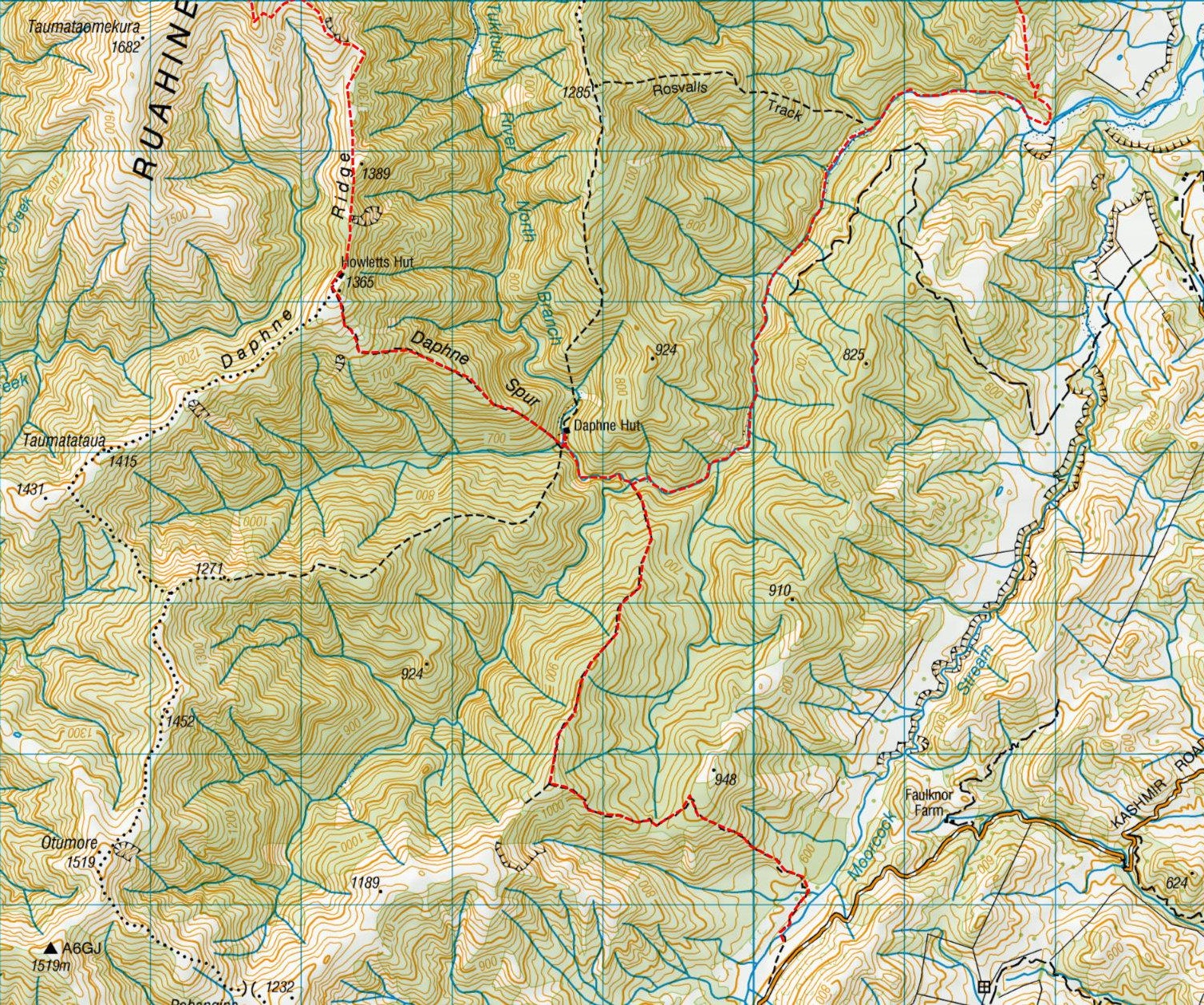
The final plan is to go in at the lower Kashmir Road carpark, over the ridge to Daphne Hut, up the spur to Howlett's hut, along Daphne Ridge and climb to Tiraha. This is where I confront the mighty sawteeth on the way to Ohuinga. After that there is a drop to a saddle and climb to the southern point of Broken Ridge before dropping to Hinerua Hut. A possible side trip to Smith's Stream Hut for the night ended up being canned in favour of a shorter route out the next day from Hinerua down the ridge to the Tukituki River and up river to climb back over to the carpark.

Sitting back and looking at it I have mild concern about the net altitude gain on Saturday given my current level of fitness. However, the forecast looks basically good with a bit of cloud.

What:    Tramp
When:   25-26 January 2020
Where:  Sawtooth Ridge, Ruahine Range
Who:     Solo
Maps


Up at 4.45 and I'm already near Masterton when the sun seeps over the horizon for the start of what is shaping to be a fine day.

There's no reason to stop so I head north and onto highway 50, into Ashley Clinton Road, Mill Road, Kashmir Road and shoot past the carpark turnoff. It's a little way up the road before the first turn around spot. The drive down to the carpark is ok but second stage pioneer species are threatening to move into the middle strip.

There are three other vehicles and I wedge in without blocking anyone - one more would be tricky though.


The morning is already hot in the small valley at 8.50 as I get myself sorted and off through long grass - you would get soaked in a heavy dew.  Sporadic poles mark a foot trail a little way down valley, across Moorcock stream then a side stream. Then the climb starts. There air is still and already baking. The 300m climb takes me above the opposite ridge giving views across the plains into a hazy distance. 


Moorcock Saddle at right

The scrub eventually gives way to forest shade and a short drop into a saddle where I meet a hunter. He's out for the day and after seeing a stag on the tops in the early morning is now looking for a marker to a clearing to stake out. He's seen two other hunters.


Another 200m up and I'm at the ridge for the long potter down to the river. Long tailed cuckoos are calling but as I approach they either fall silent or give an alarm call zweet! zweet! followed by a scolding/alarm Zweetzweetzweetzweet! before lighting out. I only manage to get a glimpse of one in looping flight as it heads for less disturbed pastures. Interestingly I don't hear them in the valleys during the weekend.

I bump in to a Canadian coming out after a few days and overnighting at Daphne; he confirms there are two hunters at Daphne and a man and two teenagers heading up to Howletts. The bush telegraph is working.

The odd break in the canopy gives a glimpse up towards Sawtooth ridge running away in the distance.

I keep my feet pretty much dry getting up to Daphne hut (11ish) where I stop to use the facilities and leave a note in the log. The two hunters and their wee dog are settling in for a bit of a rest after their morning hunt. They've picked up a spiker so reckon the pressure is off for the weekend. They'll probably head up a stream a bit later on, have an evening hunt then hunt out down the river in the morning. They're interested in my plans and think the distance for the day is a bit crazy - hunters and trampers think about terrain a bit differently.


I get away again around 11.20 and fill up with water before settling in for a long slow 700m climb to Daphne Ridge. It's very hot now, a wee breeze provides some relief higher up but I'm needing to take a few breaks to keep the heart rate at a reasonable level.


Last view of Daphne Hut


At the bushline I catch up with the family group (at least I assume it's Dad plus two) sitting down for a snack. They've taken an even more leisurely approach than me but are staying at Howletts so have all day. It's a good excuse for a break and chat and I can give them a bit of intel about Daphne Ridge which they were wondering about travelling tomorrow. The boy and girl have their cellphones out but seem pretty happy about the experience which is impressive after the climb they've just done. I leave them to it expecting to see them at the hut before I leave.

There's still a bit of climb to the top but the breeze is stronger here and I get a bit of evapo-cooling as my sweat soaked bush shirt dries.

At the ridge the tops to the south look rounded and benign compared to those to the north. In the east, Black Ridge runs north along the headwaters of the Tukituki - I try to pick out the wee saddle where Tarn Biv is tucked off the other side of the ridge.


Howletts Hut

At 1.10 I reach the unbelievably picturesque Howletts Hut and have a longer than necessary break for lunch. The family turn up as I'm preparing to leave and we end up chatting again. Asked about my route I think I point out the correct lump on the horizon as the south end of Broken Ridge and my last high point for the day. It seems a long way off.

View from the loo

I finally get away at 1.55, the Ridge is easy for a while with a good foot trail that sidles when needed. Sawtooth Ridge is looking increasingly steep and craggy with proximity with some faces you wouldn't want to slip down.


Part of Sawtooth up to left, Ohuinga middle on horizon

At the end of the ridge a solar garden light marks where the climb to Tiraha starts. The foot trail becomes harder to follow and fades as it curves across the face to climb steeply to the spur that approaches Tiraha from SSE. Although steepish the face is straightforward.


Looking back at Daphne Ridge
Howletts Hut on lump beyond the bare bits


Looking along Sawtooth Ridge 


Tiraha (1668m) at 3pm and a long sit down to study Sawtooth, admire the view and drink.  The wind is getting up from the west and although high at present clouds are gathering in the west.


From Tiraha along Sawtooth Ridge 


Descending to the first tooth the ridge top has various wee foot trails and it's easy to find a way. I probably dropped a little low into a chute on the first craggy bit but soon scramble back up and find that there is generally a bit of a foot trail most of the way across with good sidles in many places. You have to watch carefully for where they head back to the crest though because you can end up in annoying tussock and low scrub or with a steepish bluffy bit to retreat from.

The wind starts getting up but so far is firm rather than frightening. There are plenty of bits where you are on a very narrow ridge top or scrambling with a bit of exposure but nothing I'm uncomfortable with and I never feel the need to stash my walking poles to have two hands completely free.

There are a few interesting looking spurs dropping east towards the Tukituki but I suspect they get steep and nasty once they drop out of sight.


Part way in, looking back to Tiraha


Black Ridge - and interesting looking spur 

At the end of the teeth there's a bit of a climb to Ohuinga. On the way up the view behind opens up with Howletts hut a cheerful orange dot in the distance.


Narrow bits done - back towards Tiraha

The wind is now a bit annoying and a few steps off the ridge to the right brings instant relief.  The top of Ohuinga (1686m 4.50pm) gives views of what is reportedly an interesting stretch of ridge toward the Hikurangi Range and Mangaweka (1731m) - noted for future investigation (Hawkes Bay Ridge). Also, the tops I scrambled around in clag a week or so back (Paemutu, Rangioteatua ...).  Below, the saddle I have to negotiate to the last high point for the day is not fully visible yet.


Hawkes Bay Ridge


From Ohuinga to Broken Ridge
Paemutu at left, spur to Hinerua at right


Hoisting my pack I catch a whiff of meths. This could be a very irritating thing indicating cold dehy meals or having to light a fire. Fortunately I keep the bottle on the outside of my packliner so it won't damage anything if it leaks. Not too much has been lost - the bottle top must have been cross threaded so it might be time to lash out for a new Charlie's juice bottle.

There's not much of a trail through the saddle that I can see.  I pick my way across the top of the wee basin where a water course is starting to form - the genesis of the Kawhatau River. 


Back into the saddle, Black Ridge on left, Ohuinga top right

A foot pad develops once I have climbed a bit and am on the spur that approaches Broken Ridge from the south. The wind is strong now and I need another long rest at the top (5.40pm). I'll not be going to Smiths Stream Hut tonight and send a text to confirm the changed intentions.


Broken Ridge to left, Pt 1715 on ridge at right

The lee of Broken Ridge gives temporary relief from the wind as I chase my shadow down the long spur. As I progress more of the saddle between pt 1715 and Paemutu comes into view to the north west. The spire is just a dimple on the horizon from here.


Paemutu-1715 Saddle on horizon


Knob in saddle at right, spire to left near centre


There's a couple of bumps to negotiate on the way down and once again some nice sidles. They really do better on this front then the Tararua Ranges.

The wind and weaker late afternoon sun are draining the head from the day but I've paid my dues for a poor choice in clothing. A bit of a regroup in a sheltered wee basin to suck down most of the rest of my water, scoff a muesli bar and rest tired legs before tackling the last section of ridge along and down to the bushline.  I note some doable looking options to drop to the stream above Smith's Stream Hut on the way.

The trail gets stronger and on the final knob the poled trail starts (around 7pm). It looks like there could be a viable spur route to the left and down to Smiths Stream.


From the last knob looking north along edge of range
Start of track to Sunrise somewhere in the distance

Spur from Smiths Stream Hut to 1715 runs from right


Start of the marked route


Once in the bush the track drops steeply but it takes a while to reach the saddle (7.20pm) where in short order there is a sign for the junction to Smiths Stream and then Hinerua hut (7.23).


Hinerua Hut


At some point the wind has dropped away and the evening is now calm. So much so that the hum of a truly staggering number of blowflies is the loudest thing to be heard.

Hinerua is an old four bedder. The bunks are old and steel with new wooden slats and the tiny fire box has hot plates and a kettle.  The loo is nowhere in the offing but I eventually find it further along, and pretty much on the track.

The familiar hut routine passes the time. I'm reading the log and waiting for the dinner water to boil when a tickle on my back turns out to be a large and healthy cockroach. A good blast with the spray (yep - the hut has bug spray so the flies, cockroaches or both are obviously a known feature) sees it scuttling off behind the table leg.

Over dinner a tickle on my barefoot heralds the cockroach's return, presumably for revenge or more of that stuff that made it a bit woozy. A smart blow with the can sorts the matter out and I have no more troubles.

The night is completely still. Outside the blurry stars wheel overhead (really should have worn my glasses to the loo) and I completely sleep through the earthquake that reportedly gave the lower North Island a bit of a jolt near mid-night.

I usually find that as I go to sleep and wake up I work through any decisions required for the morning. I wake to daylight and the knowledge that I won't be dropping to Smith's Stream and back before returning to the car. It's a good call but there is still a bit of a question mark about the route to the carpark. The DOC track follows the ridge and reaches private land before dropping to the Tukituki River.

I decide to head along and see if there are any signs or alternative routes. The starting Plan A is to head up the Tukituki river to the true right side stream before the track to the carpark and follow the stream up to where the track dips through a saddle.

The day is clear and blue and promises to be another scorcher. At least I'll be in bush and by water for a good chunk of it. I get away around 7.50 to head along a wide and well marked track, through a wee saddle to the junction at pt 1061. Heading right I follow down and along the ridge picking up reception to send a text along the way.


Pt 1061


Bush / farm edge

The forest abruptly gives way to farmland (8.50am) - there's a newish fence with a style and no signs that I can see. I follow my nose down the steep and slippery slope beside the fence to the bottom where there is a DOC triangle and another style.


Tukituki River ahead right of centre 


To the south is the end of the ridge between the Tukituki and Moorcock Stream - I can see a building in the bush part way up. Although there are old 4WD tracks I can't see anything that looks like a drive so figure it is a private hut not a house.

To the south east is orderly farmland and the end of Mill Road - an access point but apparently requiring landowner permission.

Below the style the track is pretty overgrown and I lose and find it as it drops and follows old terraces to the bottom where there is a DOC triangle and sign in high grass. It's about 9.20.


Mill Road end and Moorcock Stream somewhere in centre

At this point I could cross the river and head to the Mill Road Carpark (bad idea as it would then involve a long road walk to the car), head up Moorcock Creek to the carpark (likely to be quickest and easiest option but crossing a lot of farmland) or head right up river to exit to the carpark by the track I came in on.

I don't have permission so figure my best course is to follow up the Tukituki River and back into the park. I thread a way through grass and scrub to the river.

There are wet foot prints on the river bank and I work out there is a set heading up and back this morning - plus plenty of others of indeterminate age.

It's an easy potter up the river, I'm trying to avoid deep bits and managing to keep my feet dry. At one point early on I find an old benched trail on the true right that speeds progress up temporarily.

A long grassy flat on the true left and an orange triangle marks where Rosevalls track climbs 800m to Broken Ridge. It's about 10am so about 40 min up river from the bottom of the hill and 2hr 10 from the hut.


Rosevalls track at right


10 minutes later orange cloth hanging on a branch on the true right catches my eye. It's a Stony Creek product with pockets and has a bag of tent pegs in it. I can't work out what it is an am tempted to remove it as rubbish but it looks new and it might have been left for pick up later so I leave it.

I'm now following fresh wet prints and suspect I will catch up with the person soon. I'm not keen on sneaking up on hunters so when I round a corner and see a figure under trees at the river edge, I give a whistle and wave.  An answering wave indicates I won't be shot so I head up and stop for a chat.

The fisherman turns out to be staying at the lodge I saw and confirms that it is private. There's a fish in the pool that he's casing out but it seems that they are generally pretty small here abouts. He also saw the Stony Creek thing and refers to it as a meat bag.

Some of his mates are hunting and I'm a little disconcerted to hear that I have probably wandered past one on the way up. We talk about the area and he notes that there are private tracks on the true right valley side and he's a bit cagey about access. It seems to be another example of access control to favour mates and maintain hunting privileges.

He refers to the two larger creeks I have passed as Ranunculus and Government Creeks. Neither are marked as such on the map but there is a Government Spur. It's not the first time I've come across local names that don't feature on the maps.

A little further up valley movement catches my eye - a falcon is cruising at tree top height and a couple of swallows chase it out of sight. I wonder if it had a go at one and they were now taking advantage of it's lower maneuverability without the advantage of height and speed.

I haven't been seeing the number of true right tributaries that I'm expecting and at 11.25 am just thinking that I should study the map when I recognise the terrace I am crossing. Sure enough, I've overshot and got to the track.

It's a bit under a km back to the stream and although I'm tempted, I decide to cut my losses and just head out via the track.

It takes an hour 15 minutes of hot, slow, laborious plodding to get to the sign at the top of the carpark track. There are fewer cuckoos today and I assume they have the sense to be hunkered down somewhere out of the sun.


It's 12.40 so time for a good long lunch stop and to shed boots and bush shirt. A 25 minute break does wonders for my temperature.

As expected, once out of the forest the descent through scrub is even hotter than yesterday. Across the valley there's only my car in the park and it resolutely refuses to look any closer.

At last the slope eases and I get to the first creek - it's too shallow to sit in but I give my top half a good rinse and head back to the car via the slightly larger Moorcock Creek with shirt in one hand.

A camper van has turned up in the short time I have been out of sight. The couple are looking for a lake or river - so I point them to the track but suggest that they don't get their hopes up if they are thinking of swimming.

So, 2pm and that's it for the weekend's walk. My boots have built up an impressive pong having been hot, damp and walked in for two days so I'm pleased to sling them in a rubbish bag and liberate my feet.

The only thing now is to endure the hot trip back in time for 6pm dinner in Tawa - which I manage with five minutes to spare (a bit under four hours).

Postscript

The area around Kashmir Road has good huts and is pretty enough but sees a lot of hunters and trampers.

Sawtooth was a nice section, I can see that it would be tricky in bad weather and a bit intimidating if you are worried about heights. Having a clear day pretty much removes the need for navigation and the views are fantastic.

The rest of the tops were pretty straight forward in this weather. There was a lot of up and down though and you have to be confident in your ability, fitness and know the viable bail out routes. It could take a long time to get to a hut in bad weather.

Although pretty tired after the long drive and walk on Saturday it was a reasonable day - I just made it worse for myself by not allowing for the temperature.

Hinerua Hut is a nice wee spot - basic and no views but sweet. There seems to be two access options to the park boundary from here with DOC tracks towards both - I think land owner permission is probably required for both but I don't know the details. I ended up crossing a bit of private land - it didn't look like a part of the farm where you would cause disruption (maybe avoid during lambing). An alternative could be to head SSE from the hut to the wee knob at 1000m and follow that spur down to the creek.

The Tukituki River was a good easy amble.

All up, a fun weekend that reminded me how fit I ain't.


Tuesday 14 January 2020

Rangioteatua

This is the third and final of my Christmas break trips.

With my knee still whining about the slip a week or so back, I reluctantly shelve a tricky little Tararua excursion that I have in mind. Initially I start looking for something sedate in the Ruahine Range that will take about 5 days and not tax things too much. But with so much scope and not wanting to leave anything out I may have got a little carried away ...

The plan ends up as something that looks like a 4 and a bit day trip essaying two loops centred about Te Atuaoparpara and covering a lot of tops and valleys.

The forecast is stable and dull, promising challenging navigation, but little in the way of views. On Tuesday afternoon I finalise the plan, write up an intentions sheet and chuck a five day pack together.

What:    4 day tramp
Where:  Western Ruahine Range
When:    14-17 January 2020
Who:      Solo
Map


It's a long drive to the road end at North Block Road - this is the main access point to the middle eastern part of the park and the location of the massively popular Sunrise Hut. But more importantly, some interesting looking tops and valleys.

The route is easy to find off SH 50. But it's a long drive into the foot hills ending in a good quality farm track (fine for a towny car). There are two cars and a DOC ute at the carpark, good - not too busy. The DOC sign predicts 1hr 30 to Waipawa Forks Hut, my destination for the night.

It's 6.54pm and gray as I potter SW along the farm track to the Waipawa River. You can drive this bit but the final downhill is marked for 4WD only so I'd recommend just doing the 1km walk.

The Waipawa river exits the hills in a small scrubby river bed. There's a black ute parked up indicating someone(s) else will be at the hut - the bonnet is cold but the foot prints I follow up the valley are fresh.

It's easy travel up the typical acreting river bed. The terrain is a bit of a challenge for my knee and I'm making heavy use of my walking poles when the end of one comes off and disappears in the water.

I can't see where it's gone so after testing the end of the other pole (yes it floats) I chase off down stream. Nothing. Finally after working out that in fact it won't float because the locking mechanism is still stuck in the remaining section I locate it in the bottom of a pool. Much farfing about and a wet boot later I have it back together and am on my way.

The valley pretty soon opens out into wide shingle flats - I'm concentrating on my footing and almost waltz past a cairn, triangle and sign indicating the location of the hut on the true right. The hut is up a track and is not visible from the river.

It has taken about 1hr 30 including the farfing about with the pole, so a good easy evening stroll-in which could be done after work on a Friday by torchlight. But paying more attention for the sign then I did.


Waipawa Forks Hut

A large black labrador greets me as I approach the hut - four kids and Dad are well ensconced having arrived earlier in the afternoon. They're from the ute and from Auckland, but used to be local - it's good to see them reconnecting with their place.

My initial fears of a noisy night are short lived - the hut is in two halves so I have a room to myself and they're considerate. I head straight to bed to the sound of morepork in the valley and what sounds like the largest rat, which turns out to be the dog's nails on the porch.

The children are quiet in the morning even though they are up before Dad. We exchange a few pleasantries before I head off around 8am.

For a start I'm looking forward to a 600m climb via the river headwaters to the Waipawa saddle, then 200 odd meters more to the Three Johns. Some interesting looking tops travel will take me over Rangioteatua and Paemutu before descending to the Kawhatau River and Waterfall Hut.

The Waipawa river is straight forward. I'm having to be careful with my knee but the valley floor is pretty open and taking it steady things are fine. The tops are shrouded and there's little wind.

I'm well on the way when a blue duck flies down the steep rocky bed about head height - I'm really surprised to see it as I thought the creek was too small by now. I wonder if it is a younger solo juvenile that has been kicked off one of the rivers further in.

It gets steeper, with some shingle scree to navigate.  There's the odd cairn and foot pad but nothing you couldn't afford to miss until a large orange triangle on some stunted beech marks a track up through low forest and then alpine scrub into Waipawa Saddle.


Looking up towards Waipawa Saddle

The saddle gives views back down the valley to farmland that is enjoying an overcast day. West it looks like high broken cloud, but here the tops all have a mantle that comes and goes a little. The wind is light but chill.

It's about 9.50 - almost 2 hours from the hut. My knee is still cooperating so I give myself the green light and turn left towards the steep gravel slope that disappears into the clag in the direction of the Three Johns.


Down the Waipawa River


Southwest from saddle - 1635 (on my route) on left, Rangi Saddle ahead

It's a steady climb with a bit of a foot trail in places. The Three Johns are slightly off route but not by much so I figure it's worth a look. It proves to be easy going provided you stay away from the sharp bluffs and erosion chutes on the north face. At 10.40 the top is in clag and I have to check the map to confirm that I have to go a little further to reach the last John. As I arrive the clag clears briefly to show a long ridge running NE down towards the Waipawa River.


The last John

Possibly another way up?

I retrace my steps and veer left when another wee intermission in the mist gives a glimpse of the next saddle and the ridge beyond. There's a bit of a foot trail, generally towards the edge of the steep south east face. I lose this towards the top though and have to find a way through thick tussock with cunningly concealed spiky spaniard.  It's a bit tough on the knee.

At the next high point (1635) I was hoping for a view back to Waipawa saddle but the clag remains stubbornly thick. I buckle up for a similar climb up to Rangioteatua.

The top here is broad and rounded with exactly the same view as 1635. It's just after 12 so I stop for a bit of lunch and hope for the clag to thin. No luck. However, the knee is holding up well, and although it's chilly there's little wind and it's not raining. So far things have been pretty straight forward.


Rangioteatua

Under way again I follow along the ridge through the murk to the high point for the trip: 1715m.  There's a trig marked on the map but there's not much left of it - a few timbers on a small rounded shingle knob amid a sea of gray.


Pt 1715 - or A6G4 for short

Onwards and downwards?


It's 1240, I sit down to study the map as the next bit is a little tricky - the ridge drops away steeply 200 odd meters to a saddle and I'm bang on a join in the map (a disadvantage GPSs don't suffer from).  I can't see much of a ground trail so follow the compass and scramble down through some rocks. A little lower, the clag thins enough to make sense of the landscape - and the long saddle with a knob in it comes into view. Still on track.


Starting to thin ...


Saddle to Paemutu


The landscape ahead looks dramatic. Paemutu is invisible, apart from the lower flanks of forbidding scree and rock. The saddle looks lumpy but doable but the approach to Paemutu itself is hidden behind the knob in the saddle. Only one way to find out.

From here it looks like a plausible bailout route to drop into the headwaters of Waterfall Creek. However, if the name doesn't put you off (and it should!), I find out later that the lower reaches have some significant hurdles.


Approach to Paemutu

Past the knob there's a flattish bit leading up to a spire of rock that looks dodgy. From a distance I work out a couple of lines of attack and head up to investigate. There's a small stack of rocks that might have once been a cairn (hard to tell in this landscape) and a faint line on the herb field on the SE side of the ridge that might be a foot trail. It points to my plan B route so I follow. This drops a short distance then allows a scramble up onto a sharp edge and over onto a tussock face. From here it's just a steep grunt back up to the ridge - trying to avoid the spaniard. I emerge just behind the spire and try to make out what Paemutu has in store next.

The poor visibility probably means I miss some easier lines and I find myself tending left into some steep chutes of mixed shingle, and herb/low shrubs. It's hand over hand work; double checking each hand and foot hold and listening to dislodged rocks skittering down the shingle slopes below. However, I'm feeling pretty secure and suddenly realise I'm enjoying myself for the first time on the trip.

At the top (2pm) I drop my pack and take a few minutes. The clag is coming and going and I can see back to the spire at the start of the climb - my route forward (SSE) looks rocky and forbidding but that will keep for a few minutes.  NW the clag fades and I can almost see down Broken Ridge - I had planned to descend this way but had a last minute change in mind as I didn't find a reference to it as a viable route and I was a bit worried about rock climbs and scrub battles with a dodgy knee.


What comes next ...


NW down Broken Ridge - flats below Waterfall Hut almost visible

The clag starts another fading routine and I can see into Tussock Creek. It also reveals a hare loping across the face below me and disappearing around a fold in the hillside.

I read that Tussock Creek is a viable route down if you head along the ridge a little from Paemutu, drop SW onto the first obvious spur and pick a line NW into the gully once the slope eases (say around the 1580m contour). The clag recedes further and I can see the spur on the true left of the catchment and that it looks like a clear run down to the Kawhatau River - 560m below.


From Paemutu looking into Tussock Creek

The clag has all but gone as I shoulder pack and follow along what has suddenly become an undaunting ridge. Once I can see the slope below I start to descend the scree, trying not to disturb where alpine plants are starting to recolonise. Once in the bottom of the gully the footing gets steadily trickier - with larger shingle which is a bit less predictable and soon tussock and shrubs. But pretty soon I'm taking a cold drink from the stream as it first emerges from under the rocks.


Looking down Tussock Creek from part way down the scree


Once the creek starts getting to a reasonable size there's low close scrub and I work my way carefully down in and by the creek. This is the harshest test of my knee so far and the poles are a liability.

The clouds have virtually disappeared - I've stashed my coat and am contemplating sunscreen. Ahead a lumpy ridge on the horizon could be the south end of the Hikurangi range - I should take a bearing to confirm whether I'm looking at Mangaweka (1731m) but ... didn't.


South end of Hikurangi Range?


Finally I'm scrambling down the last wee cascade of Tussock Creek to meet the (not so) mighty (yet) Kawhatau River. It's 3.20 so, including the stop at the top, it's taken about an hour 20 to descend.

The Kawhatau starts on the slopes of Broken Ridge and flows north then loops west out of the ranges to eat the Pourangaki River before being consumed in turn by the Rangitikei - just north of Mangaweka (think DC3 plane on the main street and those iconic papa cliffs above the river).

My first introduction is very pleasant - the river is small here and immediately enters a short stretch with beech growing close in around clear blue pools and variously hued boulders.

I had wondered about this section being a bit gorgy but although the valley sides are steep it turns out to be mostly a fairly easy wander along shingle banks, across terraces and although there are innumerable crossings I pretty much keep the river out of my boots.


The Kauwhatau River

I'm taking a short cut across a terrace on the true left when I suddenly spit out on to a shingle fan. This must be Pinnacle Creek - an access route to the tops and one of the significant routes to and from Waterfall Hut. Pinnacle Creek marks the start of the flats at the junction of Waterfall Creek and the location of the hut.


Flats near Waterfall Creek

I note the two large DOC triangles on the true left of Waterfall Creek at the junction but think that these are marking a track, not the hut. Instead I head across the mouth of the creek to a terrace where my map says the hut is. It isn't. Back to the triangles and I follow a short track up to cross the stream again to the hut.

It's an interesting study in the resolution of the Topo50 maps - to scale, the square marking a hut is 50m across so the compromise in positioning means it looks closer to the river than it in fact is. Well, that's my excuse.

The hut is an old school orange 6 bedder with an open fire. It's 4pm and I'm of half a mind to continue to Waikamaka Hut but this will do nicely and I can use the rest of the afternoon to check out why it is called waterfall creek.


It's nice to potter up the creek without a pack - a few minutes up I realise I am also without cellphone so no photos I'm afraid. I soon come to a pool with a meter or so waterfall - this clearly doesn't warrant naming rights for the stream and hut so I manage a tricky little scramble that threatens to tip me thigh deep into the pool and continue up stream. A slightly bigger waterfall a little way up is also surely just a promise of things to come. This time a bit of a rock climbing move on the true right sees me up with still mostly dry feet.

I find myself surrounded by intimidating cliffs - up to my right there's a bit of a ravine with a dry waterfall at it's head (this is probably the wrinkle in the contours on the map just above the marked waterfall). The main stream drops maybe 10-15m into a basin above my head and cascades down through large boulders.

Scrambling up to the pool I can see that the top of the falls is not a place that you would want to reach on the way down. The water emerges from a slot and smashes down on to the rock - the sides are sheer and slippery.

It's also not really the sort of place to sit and contemplate - after a brief look I start back down. A few steps later a couple of boulders about the size of your circled arms roll from under my foot and crash down a couple of meters. The smell of crushed rock drifts in the air - a bit of a wake-up call and salient reminder of how stable this place isn't.

I beat my retreat managing both scrambles without taking a dip and am happy to see that I still have the hut to myself.

The hut bears the hall marks of a hunters retreat - empty boxes left over from helicopter flights in and stuff left behind ostensibly 'because someone else might find it useful' - but in reality now just junk (empty lighters, non-functional lights, tag ends of food, cut off gumboots ...).

It's cool out but I sit by the creek to eat dinner - I have some sympathy for those that prefer to camp as you are closer to the environment. It's true that when you close the door to the hut you close off  all those little noises and smells that tell you what's happening in the bush.  But then, I quite like to sleep and not have to fumble my way out of the tent to go for a whizz.

I try to do a bit of a tidy before leaving in the morning, but this early in the trip I'm not about to carry other people's rubbish. It's almost 8.10pm before I finally get away. The morning is cool and overcast again.


Random erosion in Rangi Creek
About 12 minutes after leaving the hut I'm heading up Rangi Creek. It's like most of the streams around here - a conveyor belt of broken rock from the naturally eroding hills.

The valley bottom starts flat but I'm soon picking my way over rocks and past the odd shattered tree. It's not far to the markers indicating the start of the track.

After that it's a 300m grind up to the saddle; transitioning from the ubiquitous beech to scrub and tussock. The odd triangle has fallen off it's pole so there's little to mark the route from above, but if you  follow your nose down the guts and start to drift left you'd pretty quickly find the route into the bush.


The way up to Rangi saddle (SW side)

Predictably for this trip, I have climbed into the cloud ceiling again - it's taken about 1hr 15 to get here. There's little point hanging around and I scout about for the way down. There's no discernible trail but there is a waratah on the NW side of the lump in the saddle. I pick my down through low scrub, tussock and spaniard, occasionally possibly on a trail of sorts. I'm soon saturated from the thighs down from the damp foliage.

Reaching a wee stream and looking back you can see a lump - coming up you would aim to the right of it and maybe find the odd waratah on the way up.


Looking up to the saddle from the NE side

The route down valley is the familiar transition from low scrub to bigger veg and an increasing stream with bigger boulders. There are a few spots with cairns marking easier routes and in places DOC marking. It's fairly slow going with a bit of scrambling around the stream, fallen trees and scrub. There's an obvious junction which I think might be the river but isn't - it's a bit further to the river but the stream is quite sizable now.

At 1015 I reach the end of the creek and DOC markers and a sign indicate the hut on a wee terrace above the river (true left). It's another one of the cheerful blue Heretaunga Tramping Club maintained facilities. A little over 2 hours from Waterfall Hut.


Waikamaka Hut


The hut reeks of care and attention - right down to the way someone has hand crafted a latch for the hut book box. The last visitors were apparently two weeks back. 

I take a bit of a snack break and keep a jaundiced eye on the weather which is making a sullen attempt at rain. The wind is still gentle but cool. 

25 minutes later I'm heading up river to Waipawa saddle. The route is pretty much as you would expect - a typical rocky stream bed getting steeper. I notice a waratah on the true left a few meters away from the creek but can't see a foot trail so keep following the creek - it immediately passes a wee rocky bluff on the true left then enters a steep erosion bowl. The creek drops from a fall on my right. 

There's no sane way out of here so I back track to the waratah and this time see a trail that climbs steeply to the top of the waterfall and crosses the creek as it drops into the basin. To my right the stream drops over another fall from the headwaters - the map shows the bend in the creek and where the track leaves it climb into the saddle. 


Headwaters waterfall

The route up
Back in the Waipawa saddle (about 40 minutes from the hut), I face the familiar proposition of climbing into the clag again. Comments in log books have indicated some opinions about the best routes past 1625 and up to Te Atuaoparapara. I figure I will make it up as I go along.

The climb starts steeply on loose scree and pretty much continues in that vein - I can't recall any dramas that the odd sidle doesn't resolve.


Looking back into Waipawa Saddle 
(and the start of the route to the Three Johns)

As I round over the shoulder on to the top of 1625 (just after noon) I guess I shouldn't be surprised at how expansive the tops are - as the clag comes and goes there seems to be knobs and tarns looming up all over the place. I follow my nose along but could probably have kept a little more right (east) than I did. There are a few wrinkles in the landscape with deep tussock and tarns which take a bit of navigating if you find yourself on the wrong side of one.


Woohoo! 1625! - Looks pretty much the same as every other top so far


A wrinkle in the landscape


After what seems a long aimless wander along the top in the fog the ridge starts dropping, all I can see ahead is a massive scree slope disappearing up into the clag with no obvious track. The ground drops away to the west - I can't tell how far but am not about to go down to investigate.

I start the climb from above the bluffs in the east and angle NW up the slope. There's a few patches of crumbling rock which offer a little more purchase than the scree and with patience I head on up. Once again I reach some bluffy rocks and find a route around to the west and back up to the ridge. The east face is a series of chutes dropping into the clag. The odd dislodged stone rattles rapidly out of sight down the black maw.

Another wee knob appears out of the mist - this time wearing a hat. Te Atuaoparapara (1687m).


The weather is pretty much the same as usual - cool, not too windy and occasionally venturing a bit of moisture. I have a wee refreshment break and map check. The next bit should be a bit more trod as it is the way up from Sunrise Hut. Navigation should be straight forward - basically trending north east and down.

Going down is a little more tricky on the knee so I'm watching my footing when two figures emerge from the mist. A couple of chaps are heading over the top to Waipawa Saddle. They've just done trips on Taranaki and in the Tararuas and are finishing up by doing the Atuaoparapara loop.

I discretely check if they are aware of the route off the top as there are one or two bits I imagine are easier on the way up then down - especially in clag. Turns out that one of them has been over previously so knows more about the place than me.

There proves to be a tricky bit in the saddle where the foot trail becomes hard to follow in scrub and tussock - I suspect it veered right and I continued on. It's not a question of being lost, it's just a bit of unnecessary thrashing about and swearing.

About 1.50 I'm at the junction - right to Sunrise Hut, left to Top Marapea Hut (historic). I suspect that (historic) means they haven't replaced the open fire place with a woodburner,


A good poled track bounces up and down along the ridge then drops through bush for a steep descent to the the hut. It's trying to rain again.

This is my target for the day but at 2.15 it's just too early to knock off. I have a good half hour break for lunch though. The hut is a small and tidy (historic) four bedder.


Top Maropea Hut (historic)


The track from the hut drops and sidles then plunges off the edge of the ridge. On the way down and towards the bottom keep your eye out for a view of the pretty wee waterfall just upstream ('just' like 50m).

It's an odd thing - the route notes I have seen talk about finding the slip and the marked track. They could just say - go up stream to the waterfall, have a good look at it then turn around and you'll pretty much trip over the track.

Once again I'm surprised by how navigable the valley is. I can pretty much hobble along waving my poles around to keep on a straightish line. About half an hour from the hut I reach the headwaters forks - a little under half an hour later the major forks. 1hr 50 and I'm at the large flats and start seeing stoat traps. I startle three deer on the way, one of which sets off a small series of avalanches as it leaps it's way across the top of an erosion face.


Random waterfall

By now the day has changed again. The sun is coming and going and I've shed my coat. There's a few spots where short cuts are possible across terraces but I'm surprised how often there isn't a foot pad where there would be one in the Tararuas. About five minutes from the junction a large triangle indicates where a track starts on the true right - this skirts around into the Maropea River valley and leaves you to find your way the last 200m up to the hut.


The first view of the hut is idyllic. Surrounded by slender beech it's pristine in its spanking new green iron. There are flats in front for camping and the river sweeps around with a little bit of a pool for anyone of a washing mind. And it's empty.

The sun makes a few last valiant attempts to peer through and I manage a bit of a bush-wash using the hut basin near the river (just not game enough to jump in). My feet are a bit soggy and battered after a longish day and relish being released from their leather coffins.


Maropea Forks Hut

The hut is fantastic inside - new, clean, double glazed and with fly screens. I sit and peruse the log which only has a couple of pages of entries. The first of which is from a PNBHS group - one of whom has carved a figure and mounted it above the door. He has also left a description of what the carving signifies in the front of the log.  Clearly the place has a lot of meaning for him as the carving has been carried in and not just whipped up by the fire with a pocket knife.


The evening and night are unbelievably peaceful. There's not enough wind to set the toe toe nodding and it's just the usual birdlife doing its thing. I turn in with the fading light.

Over breakfast I study the map for the day ahead. A 700m climb to the main range then ups and downs travelling south along the tops. It looks like a bit of scrub in a saddle before Armstrong Saddle and I have no idea how challenging the tops will be. Also whether the weather will choose today to dish out a bit of punishment. Plan A is to get to Sunrise hut and maybe out to the car, plan B is to hole up for the night at Sparrowhawk biv.

A little before 7.40 I bid a somewhat reluctant farewell to the spot and head up river a couple of hundred meters to the DOC triangle and start of the long trudge up.

An hour twenty later I'm at pt 1450 with my coat on - I'm back in clag and its throwing a bit of wet about. The only noteworthy point of the trip up was a surprising view out under the cloud to Ruapehu. I have to confess to a bit of a thrill whenever I see the volcanic mountains from the Ruahine Range - they are so much closer than in the Tararuas where you're lucky to see them and even then they are hazy with distance.

There's a good foot trail that takes some sensible sidle routes to reach the saddle short of Maroparea (1511). I lose it on the way up out of the saddle - I suspect it veered right onto the ridge while I proceeded to the crest. Still it's about 1hr 50 from the hut so time is not pressing. I fluff about with compass and map before dropping from the top onto the broad ridge.


Maroparea - or ...

The ridge is so broad that any trail rapidly dissipates in the tussock so I just make my way looking for breaks in the clag to avoid the need to use the compass. It's pretty easy going up and down and a wee climb up to Orupu (1475) where the ridge veers left along a bit of a spine and drops and veers south again. I get a little tangled in scrub leading up to Sparrowhawk biv (should have kept a little further right) but find the waratahs marking the track down to the hut ok.

About 3hr 15 from Maropea Forks so we are good to go for Sunrise. Sparrowhawk biv is tucked in the bush by a wee clearing. It's a dog box with three mattresses but a built in porch with a dirt floor considerably improves the living conditions over your standard biv.


Sparrowhawk bivvy

I can see recent foot prints but it's two days since a log book entry. So I suspect someone has been about but not filled in the log - hope it's not a hunter that might mistake me for a macpac red deer. It's over twenty minutes before I get around to pushing myself out the door again with a pocket full of smarties to sustain the inner man.

The game plan now is the long slow climb to Maropea (1481), long down to a saddle, steeper climb to 1476 then possibly a scrubby hell saddle before the last climb to 1499 and over to Armstrong and Sunrise. There's a sign on the ridge above the biv that reckons this will all take about 3 hours and hopefully I'll fit some lunch in somewhere - maybe this dratted clag might even lift at some point.


And that pretty much sums up the route. I follow fresh foot prints up to the first top but these head for a spur - I assume it was a hunter and I'm pleased not to have them lurking in the clag somewhere in front of me. Otherwise, what foot trail there is is often faint and easily lost but there is generally not too bad going to be found.

About 1240 (1hr 25 after Sparrowhawk) I'm having a spot of lunch on the south side of 1476 and hoping for a break in the clag for a view down to the saddle. I'm currently experimenting with a mexican/french satay recipe - a third of a camembert and half a pics peanut butter tube in a burritto. Sounds disgusting but packs a bit of energy and is easy to eat.

As I munch, the clag lifts enough to see the saddle dead ahead. I get going quickly to take advantage of the gap and the cloud lifts further still. Soon the whole saddle and the flanks of the final hill are clear.


A few minutes later

 
This is the part of the ridge where you can cause yourself a lot of aggravation and wasted time. I reckon in the descent to the saddle when you approach the scrub it is probably best going to be had to the right (west). In the saddle itself someone has cut branches and tape marked a route that sidles and ducks and dives. It doesn't take the straightest line and the footing is pretty variable but it's worth following the ribbons. 

Out of the bush again the cloud has lifted further and I can see out to the Hawkes Bay plains and across the ranges and valleys of the Ruahines with Mts Ruapehu and Ngarahoe in the distance.


Left branch of the Maropea River - mountains on the horizon

Looking back, the ridge I have come down winds between erosion faces and dips to the bush saddle. I lose the trail again on the way up to 1499 but again it is just low herb field.


1476 and Saddle

As I crest the top of the last knob (1499) I can see the clag forming as the warm, damp air from the east rises up the range. But for now it's holding off and I can see the track to Sunrise Hut snaking along the ridge below.  


Sunrise Hut on the knob at center

It's an easy lope down to Armstrong saddle where there's an info board telling of the plane crash that gave it its name - it doesn't mention that Triplex hut got its name from the label on a shirt belonging to the pilot (he does look a little portly in the photo).


Having passed 1499 I'm now treated to an amphitheatre of faces with the highest tops still in cloud - from the Three Johns on my left to Te Atuaoparapara and the long ridge around to Armstrong Saddle.  They all have steep scree and rock slopes with the forest battling to maintain a mantle.


The ridge up to Te Atuaoparapara (top in cloud)


The path is now very good although there is one point where I follow a water channel a couple of paces by accident and find myself on the edge of a huge erosion gully chewing in to the ridge top.

I catch a whiff of smoke as I approach the hut and can't quite believe it - the day is calm down here and although not tropical it is certainly not cold. Opening the door is like walking into a sauna - the fire box is roaring and a shirt is hung to dry above it. There's a small pack with a felt cowboy hat on it nearby.

A voice comes from the bunk room commenting on it being really hot and I make some lame response about supposing it's because they haven't had to gather the wood.

It's so hot I'm starting to sweat so I fill in the log and get out again. As I head on down I'm really cross for myself for not challenging the owner of the voice about wasting fuel at the serviced hut. I suppose there could have been a reason - it had been cold and wet on the tops - but that's a reason to get into your sleeping bag not leaving the fire cranked up enough to heat the whole damn place while you laze in your bunk. Bugger - I'm still cross about it.


Sunrise Hut

In the end it took about 3hr 5 from Sparrowhawk including a lunch stop so the sign was pretty much bang on. The track now is beautifully benched, graded and surfaced and I can put a good pace together using the poles to take the weight off my gamy knee.

It's great to see that DOC have placed info boards that draw attention to the changing forest, some of the features of the flora and fauna etc - they're all brief so I stop to read them. Including the one pointing to a mistletoe in a cage - it reminds me of the two specimens I saw thriving unprotected in the Cobb - a testament to the pest control efforts there.

An hour after leaving Sunrise I'm walking up to Triplex Hut - it's very tidy and clearly gets quite a bit of use. There's a BBQ and ample space for tents - an ideal road end hut to kick off your weekend.


After that it's basically farm track back to the carpark by 3.45. A couple have just arrived to head up to Sunrise. From their questions they haven't done much tramping but they've chosen a great spot to start. I can tell them that the track is excellent but that the 700m climb is still quite a proposition to tackle.

Postscript

This is a fantastic bit of country. There are heaps of huts to choose from and you can avoid the insanely busy Sunrise and Triplex unless it suits (bookings required for Sunrise during busy season).

The terrain was generally easier than I expected so I came out a day earlier than planned leaving a nice wee buffer for recuperating before the shock of going back to work.

The tops are entertaining with a lot of straight forward ambling with some fun little scrambles mixed in. It seemed to me that off track excursions are not as prone to leather wood as further south although I can't really claim to have tested this. The rivers were at normal flow and the bits I did were all perfectly navigable with lots of lovely wee terraces if you fancy camping.

Good navigation skills are pretty important though as the tops are generally not poled and have lots of animal ground trails to distract you - quite a few of the marked tracks were getting pretty marginal to follow easily also.

There's plenty of scope to design trips from the North Block Road end from an easy weekender up Te Atuaoparapara via Sunrise through to more challenging excursions into the interior.

Some of the names on the map sound pretty significant: Rangioteatua, Te Atuaoparapara (and others) but I was disappointed not to be able to find any explanations on line. If anyone has ideas where to find out I'd be keen to hear.

A few new pieces of kit ...

There's only really one gear word of the day ... boot-dryer.  Single pair, Peet dryer from Hunting and Fishing for $89. I've only used them once and they have already changed my world. My heavy duty leather boots take an age to dry and build up quite a pong in the process. Stick 'em on the dryer overnight after the trip and you have these lovely warm, dry boots in the morning. It's not high temperature so should be kind on the materials. You can get faster models with multi ports and functions but slow and simple suits me fine.  You can probably get them cheaper online but best to support your local retailer.

This trip I was trailing my new Macpac 50L Torlesse pack. The main point is it fits well with a comfy harness system and is a good size for a short multi-day trip without too much gear. It's got a bit too much fancy stuff for my taste like some buckles at the bottom to cinch the bottom compartment up - these are right where the pack slides over the rock when you're easing off an edge so will probably rip off. I'm not keen on the separate zipped compartment at the bottom - but you can dispense with the internal baffle so I can live with it. Overall, I'm very happy with the purchase at less than $250 (on sale of course).

This is the third outing with my Outdoor Research cirque pants. They seem pretty hard wearing. They are not as warm as I was expecting but that's ok - just assume you will need long johns if it gets cold.

Vipole carbon walking poles - I've had them a little while now but have been using them more lately. Very lightweight, comfy straps and really useful on this trip. I'm pretty tough on them and although they don't have many miles on them they are showing signs of abuse - the bottom section tends to pull out of one (fixable with glue or locktight), and one foam handle slips down (also should be glueable). They are not sprung but that would be more weight. I suspect the short comings are more to do with me than the product. I'll continue to use them for trips that don't entail much bush bashing. Did I mention how unbelievably light they are?