Showing posts with label Otaki gorge. Show all posts

Saturday, 10 February 2018

Kahiwiroa Crossing

How do you create a beautiful Tararua crossing? It seems you do it by accident. This trip was an elaborate attempt to pick up four spot heights above the Aokaparangi Stream (between the Main Range and the Otaki River).

When you think about it, the Tararuas are defined by rivers and ranges. Locations and features are described by their relationship to its spines and its arteries. So ... a trip that immerses you in the Otaki, climbs the main range via a little visited valley, then plunges for a swim in the Waiohine before scaling Mt Holdsworth. All in the space of two days - is a pretty good cross section of what the Tararuas represent.

What:    Tararua crossing and nav trip
Where:  Otaki forks to Holdsworth via Kahiwiroa
When:   9-11 February 2018
Who:     Solo
Map:


Kahiwiroa Crossing - with a little side excursion

A little after 7.30 on a Friday evening the support crew takes a snap of a natty tramper about to potter off from the Otaki Forks car park.


Before ...

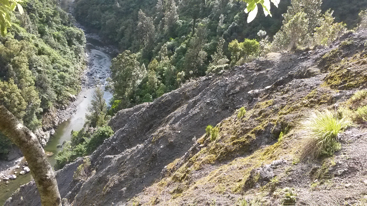
First slip - looking down river


The aim is to find a spot to camp an hour or so up the Otaki gorge. Last time through there were a couple of terraces that looked promising.

It's a bit easier getting to and across the first slip having been through once before. I'm hoping to get to the second big terrace but in the end find a spot after an hour, towards the end of the first and pitch the fly as the light starts to fade. The DD Hammocks super-light weight fly is just that - and is quite narrow so it takes a bit of farfing to get it right.

The night is quiet apart from the odd spot of rain and occasional small animal of the scampering-around-in-the-leaves variety.

It's pleasant to wake with the light filtering down through the canopy and break camp in the dry to head off about 7am.


The start - camp site approx at blue triangle

When I was here previously, I followed the old track to the big slip and lost it. This time I keep my eyes peeled and still end up at the slip with no sign of an alternative. I work gingerly down the side of the slip to the river.

Slips come in a variety of flavours - this is not one of those fresh crumbly ones that you can gaily scree run down - no, it's old and cantankerous. There's steep crumbling rock which may or may not hold your weight at each step, with a skiff of grit to make it more interesting. If you start sliding you just know you'll emerge at the bottom like you've been through a tumble dryer full of belt sanders.

On the other side of the slip I scramble up the valley side to see if I can see the old track but give it away after half an hour of precarious thrashing around and descend to follow the river. It's about 8.50am.

Afterwards - a helpful colleague suggests that if you just bash up beside the slip and over the top you eventually pick up the old track again on the other side of the stream. The old maps website indicates that in 1979 the track crossed the stream and climbed over the hill to Penn Creek but a section of track also followed up the gorge - I didn't see any sign of it but may not have climbed high enough.


Otaki River - clear and low

As previously, there are a few scrambles around deep bits and some deep wades but all doable with the river low.  It's about 9.10am when Penn Creek hoves into sight, shortly followed by pt 148, then the spur to Pakihore that I took last time. Finally, new territory.


The river chews into the base of the Pakihore Ridge

The map is quite insistent that the next section is gorgy as the river skirts around the toe of the Pakihore Ridge. I haven't been able to find any hints online as to how passable it is, so have some trepidation as to what's ahead. It proves to be all navigable, although some rock climbing is required and I find myself swimming a short distance on a couple of occasions. I wouldn't go in on my own with the river up.


A bit of rock climbing - should have swum it


The gorge section is impressive and, much as I distrust it, it is almost sad to leave the river behind. I almost barrel past the mouth of the creek I want (it's either the Whatiuru or Aokaparangi - the map isn't clear which). At 11.30am it's four and a half hours since departure and two hours twenty from Penn Creek - so not rapid progress.


Looking down river - the narrow mouth of Aokaparangi/Whatiuru on left


From the gorge to the tops

The valley starts narrow with some clambering up the stream bed but soon opens for a very pleasant wander with a bit of sun occasionally cracking through the high overcast. There are a few spots you could camp and I reckon it would be pretty cool as I think the area is seldom visited. I heard tell there was once a Whatiuru Biv but no idea where.

Enjoying the walk too much means I neglect paying attention to location and time, a few minutes are consequently wasted confirming that I have reached the forks between the two creeks. This is the point of departure for a completely pointless grunt up a very steep spur to reach an isolated spot-height.

I've been eyeing-up Pt 738 for a while and it looks as steep in person as it does on the map. It is also relentless. There's a bit of animal trail and the bush is reasonably open so it is hard and hot, rather than difficult work. My shirt is soon relegated to the pack.

The top, at 1.40pm is a relief and provides a little view of clouds on the slopes above and, on the way down glimpses of Aokaparangi creek far below but not a lot else.

The trip down is equally steep and a little more complex requiring attention to navigation and footing (who says I can't multitask). 40 minutes later at the bottom it does what spurs so often do in this country - leave you hanging tantalisingly close to the creek. A bit of casting about and a point to scramble off the slope eventually presents itself.


Forks on Aokaparangi at base of spur

The creek is cool, clear and welcome. Passed time for lunch. It's still too hot for a shirt but sufficiently overcast that sunburn isn't a concern. This really is an isolated bend on a stream among hundreds, and miles from anyway.


Not a naiad or dryad or a woodland nymph ...

The next section is a 1000m climb to the main range at Kahiwiroa via a promising looking spur. I have seen the odd report of trips through this spur and it is an obvious route to the tops but clearly not frequently used. I fossick a couple of hundred metres down stream and find a break in the precipitous foot of the spur and start to climb.

There is a bit of trail on the spur and it's easy to follow. Further up, there are breaks in the canopy that give views of the main range with clouds spilling over from the east.


Main range around Maungahuka


Dali forest at pt 1185

At pt 1185 (about 5.30pm) it finally feels that progress has been made. There's a bit of of a clearing on the knob and some beautiful goblin forest - also a slightly tricky bit of navigation to find the saddle before the final climb to the range, arriving at the top about 6.30pm. Kahiwiroa - 1320m.


I send a text to home command as I've decided that with rain forecast, rather than sleeping out I'll head up range to Anderson Memorial Hut for a comfortable night. I take the opportunity to check out the spurs down to the Waiohine and up the other side to Isabelle that I will be working through tomorrow. 

With the mucking around it takes about 50 minutes from the top of Kahiwiroa to Anderson Memorial Hut (7.20pm). As usual it takes a lot longer than expected to drop into the bush and follow the narrow ridge to the hut through mossy beech forest.

South down main range from Kahiwiroa

The hut is empty and warm. I settle in, cook dinner and check out the injuries from the day. A few bruises and scratches, rub points from gaiters, a big toe nail about to drop off (just after it's grown in again) but otherwise just the usual aches from all the climbing.

It rains solidly in the night but in the morning it is just a high overcast. The forecast is for heavy rain late afternoon.  While I'm here I've decided to pick up a couple of spot heights - the first is 1060 - a small bushy knob off the west of the range. It takes about 15 minutes to drop through scrub, and leatherwood into the bush and onto the knob. About the same to get back again.


Pt 1060 in foreground Waitatapia, Kapakapanui and a bit of Kapiti Island behind


Back on the main track I head north a short way then scramble up to pt 1226. It offers panoramic views and I take the time to recognise places I've been, places I'm going to go and places I'm about to go very shortly. Snow berries are buried in mossy corners and in among the tussock providing a bit of second breakfast. I finally drag myself away and head back to the hut - it's been an hour and a half diversion and not getting me any closer to my destination.


Spiky spaniard

So ... southwards, back along the bushy ridge and onto the shoulder of Kahiwiroa. After a bit of mucking around to get cellphone reception I text my intentions and pick a spot to depart the track and find the top of my spur. It's about 0915.


Looking north from the shoulder of Kahiwiroa up the Waiohine River valley


My spur on right - pointing at Francis Stream.
Spur leading up to Isabella on right 


There could be a trail in the tussock if you squint, but it's not up to much and easily lost. There's a bit of steep leatherwood to get through before the bushline which is much worse if you drift off the spur. Once among the trees it could be any spur under the familiar Tararua bush with a bit of ground trail which seems mostly used by game.

The route down should be straightforward, although the line of the spur proves a little hard to follow in a few spots. The main issue is not to get bluffed at the bottom as it drops to a marked gorge. I plan to drop north onto a spur at 700m that leads to a side creek.

The start of the side spur is a little tricky to find, but once on, it is strongly shaped. There's a lot of undergrowth and the rain starts in earnest so I am soon soaked through and berating my useless specs. It descends steeply and mossily.

At the base there is no apparent way off. The creek drops through waterfalls and the sides are high and crumbling. It's stopped raining but it's with a great deal of care that I sidle along the slope, eventually finding a route down to the river rather than the stream. I suspect it might have been a better option to follow the main spur then sidle to drop to the river.

No matter - it's just after 11am and the sun is striking mist off the river - loverly. It's just a short wander down stream to the start of the gorge.


Looking down river

From what I've read, this gorge has a bit of a swim to contend with. Water sensitive things like cell phones are stashed away and I wade in to the long calm pool and start working my way down the true right bank.  It would be a heinous scramble to avoid this section and to my eye there is no low level climbable route. I have a brainwave and blow as much air into my camelback as it will take, on the theory that every little bit will help.

The bottom drops away and soon may as well be a mile below my flailing boots. I use the odd purchase point on the bank to propel me forward and at last feel gravel under foot again. Whilst neither efficient, nor elegant my dog paddle has done the trick.


Looking back up the pool from Francis Creek

Francis Creek is narrow, dim, and mossy, it is also marked as gorge. By all accounts there is a route onto the spur a few hundred metres up. I'm not sure what to expect.

I don't see any obvious way out until I reach a very deep pool. The true left slope is steep but looks navigable so I start scrambling. There is supposed to be a recognised route up here but I don't see anything but goat tracks. The rain sets in heavily, making things a little more treacherous.

At 700m there is a flat spot on the spur where I figure anyone coming up from the stream will arrive - hopefully there will be some ground trail from there. A family of goats leave their shelter to precede me onto the flat where I take a breather. 

There is a fair amount of windfall up the spur so the trail is often not easy, but no more difficult than others spurs. Once again I have a diversion to execute - this time I detour south around the spur at 900m to reach the spur down to 754 - 1.50pm and another spot height down.


Very wet after swimming and climbing in the rain,
but apparently still relatively cheerful
From 994 (about 2.20pm) the ground trail gets stronger and it is a long but not difficult wander along the gently shelving spur until it steepens to climb to the bushline on Isabella. There are a couple of cairns in the tussock but not much foot trail. I think the trick is not to drift east as the scrub seems to be a bit deeper that way.

At the bushline (3.30pm), the source of the day's rain is apparent - the sky north is gloomy and squalls of rain can be seen approaching. The wind is strong but is at least pushing me uphill. It gets steadily windier and wetter.


More weather from the north.
From slopes of Isabella - my spur on left


Some good soul has trimmed the track over Isabella so it's easy to see your footing and the buffeting from the wind is a little less likely to trip you up. By the time I'm climbing out of the saddle towards Holdsworth the cloud has closed in and visibility is down to 50m the rain isn't cold so I don't bother with a coat and I don't pause at the top (4.20) before starting down the expressway to Powell Hut.


The home straight


The circuit from the Holdsworth road end up the Gentle Annie to Powell Hut, Mt Holdsworth and Jumbo, then down to Atiwhakatu to exit down the valley (or, in reverse if you prefer) is the closet thing to a great walk in the Tararuas. The tracks are well graded with lots of lovely infrastructure like stairs and drainage.

It's the sort of tramping experience I generally avoid but does allow for a reasonably quick exit from the tops to Powell Hut - I had thought the rain was heavy until just before reaching the hut when it really opens up. I thump onto the veranda amidst a tropical downpour about 4.40pm.

There are three souls in residence.  The young woman turns out to be the hut warden and is usually resident in Masterton - with her are two chaps that are doing a long trip and have come in from Tarn Ridge ahead of the weather.

I chat as I fill the log and interrogate the warden about the time to the carpark. She reckons two hours at fast pace.

The track has turned into a stream but I can potter along at a good rate down the flights of steps and along the well formed path with the rain pounding down. Feeling somewhat weary I can only muster a walk on the long flat section after Mountain House. On the down hill again I trot as much as possible and the rain clears.

It starts to get crowded after Rocky Lookout. A couple then two more with a dog are surprised as my disreputable figure shambles into sight around a corner and clomps off down the track. At the bottom, a couple of joggers then a group of teenagers wearing nothing vaguely tramping related (they were heard talking in the carpark about heading up to Atiwhakatu but wouldn't have made it by dark), then a few more people heading back to the carpark. The rain has blown through but it's still threatening so all this activity is a little odd.

At the carpark, a little after 6, and 70 minutes from the hut, the support crew administers ginger beer and sympathy in response to the old man noises that are produced as I divest myself of pack, boots and soggy gear.


... and after .... "Oooh - give me sympathy!"


Postscript

Tararua crossings are generally satisfying as they give the sense of having got somewhere, as well as having done something. This one was fantastic: marked tracks and almost forgotten tracks, mountain tops and gorges, swims and climbs, and some challenging navigation. To my mind it showcased some of the best the Tararuas have to offer.

Saturday, 9 December 2017

Waitewaewae hut and thereabouts

For some reason I don't like the Waitewaewae track from Otaki Forks. Maybe it is the number of people given it is a major gateway and part of the Te Araroa trail, or the tedious bypass track that avoids a major slip. It's completely unfair as parts of the track are quite pretty and the amble along the old tramway is unarguably pleasant. However, I am always impatient to get through seeing it as a necessary evil in order to get to more interesting (and less populated) places.

A little over half way to Waitewaewae Hut the track crosses a forest clad plateau hemmed by ridges. This marks the start of the 'interesting places' for the weekend. The ridge on the east of the plateau form the west flank of the upper part of Otaki Gorge and with some luck will provide views of the main range (not so much today as it turns out). Other potentially interesting places are a random series of spot-heights that will test navigation and bush-bashing skills at the very least.

What:    Navigation and exploration of spot-heights near Waitewaewae hut
Where:  Waitewaewae hut area and Otaki River
When:    9-10 December 2017
Who:      Solo
Maps:


Large view - ignore the unconnected route at the top - that's another trip


Day one (right side) and much of day two

Leaving the car at 7:15 it's a familiar wander across the flats, the river and the sidle above saw mill flats. To add some interest to the trip in I decide to investigate the slip that has closed the old track, arriving at the edge just after 8:00. It has grown since I was here last and chewed up successive attempts for the track to bypass over the top. I end up hanging off dubious, dry supple jack to edge across the top, noting in passing a huge tree which will, before long, take the inevitable tumble.


Slip to Waitatapia Stream 

I miss the temporary track on the other side so just angle down through the bush knowing it will be turn up eventually.

The old track is still marked and takes me to first an old boiler then Saddle Creek.


The track follows the creek bed up to finally pop over the saddle on to the plateau (9:45). It's a sort of unexpected place - you don't really expect to climb up a stream to find such a large flat area. It wouldn't be a bad spot to camp.

I'm not sad to leave the path (all too well traveled) to follow Plateau Stream down. It's not what you would call pretty - moss and algae, slippery rocks and dim pools where fish flash out of sight as I round each corner. But it soon changes from meandering across the flats to cascading through rocky cuttings as it drops through its course towards the Otaki River.


Plateau Stream - starting to get rocky

A bit dry


There are a few scrambles and some interestingly slippery rocks but overall it's pretty easy going. I'm watching the map and counting side streams closely though as there is little to distinguish my intended departure point from any other bend. At 11:10 I arrive at what I figure is the spot.

It's a steep scramble (like many others) to the ridgeline and 668, taking about 40 minutes (12:00). The undergrowth is painfully dry with the small damp loving ground plants withered from the drought.


Pt 668 - quite warm - nice and open

It looks like people have been along the ridge albeit infrequently. There are few view opportunities so naught to do but potter along. The going gets interesting at the first pt 860 - first with a diversion down to 590 (2:00) then through the saddle there is some challenging wind fall clearings to navigate. It's hard to tell what causes these clearings but they are common in the Tararuas (and ubiquitous in the Remutakas), and they are a bugger to navigate with bush lawyer and hidden gaps between rotting logs.


Pt 590 - note the leaves on the ground

Soon after the second 860 I'm somewhat startled to run into a deer fence (3:00). It just doesn't make sense until I discover it is only about 20m across - evidently some old vegetation impact monitoring site or the worlds largest deer pen (given that they are kept on the outside). There are steel stakes inside and outside the fence perhaps indicating monitoring sites. It would have been some effort to helicopter the supplies in and build it.


The ridge line runs north and down now - there are sporadic pest monitoring markers but it is surprisingly easy to drop off line with plenty of treefall to contend with when you do. Lower, there is open beech with a high canopy. I manage to work a way down to pt 450 where, as anticipated, it gets interestingly steep. The last wee drop to the river being particularly interesting. As usual it's a question of trying to spot where the animals have gone (and get worried if they seem to have headed else where) ... and to test every hand and foot hold twice.


The Otaki River looking a shadow of itself

At 4:30 the river bed is a chance to wind down a little and start managing a different set of hazards - finding the best crossing points and not having to backtrack around the deep bits. The river is at low flow and the surrounding rocks are dry so an easier proposition than normal. Some striking blood-red pools in scalloped rock depressions has me wondering if a careless hunter has processed an animal by the river but it seems to just be leaves in the water. It's surprising as it is under beech trees and I wouldn't think they would impart such a colour.

The two points I am after are a few hundred meters above the river on the true left (east). They are at the top end of a block of the park hemmed in by the Otaki River and the main range that seems to be relatively rarely visited.

There's a tidy spur leading steeply up to Pt 500 (5:25) through spindly saplings that prove hard to push through at times.  From pt 500 the contours indicate a less steep basin on the valley wall - it is navigable but the usual profusion of moss covered rotten logs demands care and the high canopy means total reliance on the compass. The scramble out is similar - up a steep and crumbling trickle choked with rotting branches (honestly - I do enjoy this stuff).


Dense rigger growth on way to 500

Stream between 500 and 666

On the next spur there are more animal trails so it is easier going with the obligatory pause for a photo at (another) pt 666. Sidling between spurs in this sort of country is slow going - it has taken an hour to get across from Pt 500.


Pt 666

The forest floor is absolutely carpeted with dry, yellow leaves, probably a result of the arid conditions recently. They tend to accumulate in the trails which is helpful and I manage to navigate down to the stream confluence as intended. It's 7pm and it finally feels like the last leg of the day.

The river has a few little scrambles and wades but soon I'm at the edge of the narrow terrace described by a long U in the river near the hut. I follow my nose across but end up a little upstream of where I want to be (the river can be quite deep along the bank here). Safely across, it is a short wander back to the hut arriving at 8:00.

Arriving at the hut reminds me of another reason I am less than keen on this part of the Park. It's just about full. I snaffle one of the last few mattresses and a few TA walkers arrive a little later to claim the remainder. The accumulation of the small casual indifferences of lots of people living in their own little worlds makes the evening and night noisy. Turning in at 9 guarantees no more sleep than the last two punters that crawl noisily into their pits after everyone else (oddly, it is often older trampers that can be a bit guilty of this). Ah well, it's only one night.

In the morning I am second up and quietly sort my life out. There are bodies spread over the verandah requiring some care in retrieving my boots but I am heading off before they rouse (6:20). The bush is damp from a bit of light rain during the night. But the ground is again carpeted with dry, yellow leaves.

The plan is to wander over the lump behind the hut then head up river way to pick up a spot-height on the valley side. I'm hoping to find an old trail on the valley floor. All going well I'll take a deviation on the way back to pick up the last couple of odd spots around the plateau.

Day two (top and left) and much of day one

The lump behind the hut is uneventful - I potter over and drop to the swing bridge. Following the river up I miss a crossing point and have to backtrack as the river deepens against the east bank - (mental note to pay more attention).  It's drizzling, if enough falls it will be very welcome for the bush (and the fire risk), it also makes the stones around the river slippery. I'm hoping not to need to follow the river though as around the  corner there is a large terrace marked on the map (opposite the Waitewaewae confluence) - I've heard there is an old track on it so cross the river as soon as I can and keep an eye peeled for markers.

Sure enough some blue DOC markers indicate a way in - I follow them briefly but don't have my eye in and follow a false trail. Never mind - it's reasonable going even off track. I manage to hook up with it a bit later and note that the ground trail is variable, the blue marks sometimes not that close together and very occasionally there is an old tin marker.  This is evidently a very old track that DOC has adopted but not developed for public use.

The trick with this morning's spot-height is finding where to start the climb. The canopy is high and the terrain indistinguishable. The first marked stream is easily identified but there are some trickles after this and I'm not sure which is the one on the map. In the end I back track and follow a stream up for a bit before picking a spot and striking out. All the way up I am working on the possibilities that I am in two different places. Quantum tramping perhaps?

In the end, when the quantum state finally collapses I am in the universe where I had hoped to be and have a short hop across a gully to pt 635. There are almost views of the hills across the valley but mostly just views up trees. Rather than following the contours around the ridge to Te Araroa trail I bash down to a stream and follow it back to the DOC track - finding a faint ground trail with sporadic markers from the side is a little tricky but at the worst I can just drop to the river. However a blue marker catches the eye and this time I manage to follow the trail all the way back to the start.

A young chap catches up with me just as I'm approaching Waitewaewae Hut. He has been having fun following a spur up to Dracophyllum hut yesterday and is now on his way out. It's good to yarn with someone that has explored some of the lesser visited parts of the park.

Rather than follow the track I cross the river and the terrace and work back to Arapito Creek. Just where the track crosses the creek there's a fork - I take the dividing spur to the ridge line (no trails) at 712 (possibly some trails on the ridge) before curving around to drop through tricky bush to the plateau and a wee ridge with pt 530 on it. The ridge is the only feature on the plateau and could be a better place to camp then the plateau itself which can be boggy.

This all goes surprisingly close to plan but the first orange triangle after dropping off 530 is a signal that the interesting bits are over and it's now just the grind out along the track. The day has been drizzling on and off but despite this the track is mercifully firm under foot.

On the way out I discover that the irritating itch on my calves is my newish gaiters rubbing holes in my legs. They look good and work well but this is another amongst a list of design faults - (I may be soft but my old gaiters never rubbed holes in the back of my legs!).

I meet a couple of lasses on the way into the hut but otherwise it's a quiet trip out arriving at the car at 3:20 to chuck wet gear into a rubbish bag and head for home.

The convoluted route required to knock of the 11 spot-heights has seen some interesting territory - I'm particularly pleased with the degree to which I've avoided the main tracks. I reckon I've seen enough of the ridges around plateau and Waitewaewae but will definitely be back to explore more of valley on the true left of the Otaki River.

Saturday, 2 December 2017

Otaki gorge and Penn Creek

The old track up Otaki Gorge from the forks has long been on the list for exploration. The main traffic thunders off up Judd Ridge, and the gorge track is no longer marked on the maps. DOC has some strong signs warning of the perils, and the Tararua Tramping Club webpage is not entirely encouraging:

"This track is no longer described nor recommended, for it is overgrown in places, and has suffered major slip damage above the Otaki Gorge, and again in Penn Ck itself. The slips above the Otaki are quite exposed. Creative route-finding and BN skills will be examined on this challenge. The attempt on this route by the insufficiently experienced has caused several SAR callouts."

That pretty much settles it - this has to be a priority for investigation. With a spell of dry weather the river is at low flow so this weekend will finally see a sortie through to Penn Creek. As well as the gorge track the plan evolves to target the lower reaches of Pakihore Ridge, a promising looking spur from Penn Creek to Table Top and, eventually, a sortie out via Sheridan Creek.


What:     Weekend exploration trip
Where:   Otaki Gorge, Penn Creek, Sheridan Creek
Who:      Solo
Why:      Navigation practice and spot-heighting
When:    2-3 December 2017


Start and finish

The middle bits

At 0700 with the car safely stashed in the overnight park, I head out across the grassy terrace towards the gorge. A hunter and dog are on their way out, probably after an early hunt on saw mill flats across the river otherwise there is no one about.

Many adventures have started from this point but for me this is the first sortie in this direction. I follow the signs and markers past an elaborate stone wall towards the mysterious gorge.


Signs of a forgotten civilisation?

Soon after leaving the grassy flat there is an easy to spot benched track on the right - the marked track continues down to the river. There's no markers to be seen but it is obviously something substantive so I follow it.

It starts well but soon gets a little messy with loose scree through the bush then steep clearings and finally an active slip. This section is a little tricky to follow and the slip is probably not for the faint hearted, but I see some rough handlines and make my way across to find the benched track again.

Down slip to the Otaki River

I find it pretty easy to follow from here with someone having taken some effort to mark the way (quite possibly the VUWTC judging by Penn Creek Hut log). At one point I pause and hear a noise from behind - a black goat has followed me around the last corner and is looking at me with it's head on one side and an expression that can only be described as incredulous curiosity. It hastily recalls the natural order of things and trots back out of sight before I can set the dogs on it.

After the first steep sidles, the track joins a terrace under mature forest (obvious on the map). This would likely be a bit of a bog at times but in the dry it is easy going. There are another couple of old slips at the end before joining another terrace.

Towards the end of this I think I might have drifted into following older markings as the track becomes rougher and eventually spits me out on the large slip around the stream from below Field Hut. I teeter across the face then assay a tricky scramble down into the stream thinking that during this process I will come across the track proper.


The big slip

Nope - I find myself on a short stretch of stream between two waterfalls with the prospect of hairy scrambles out in all directions. On the clamber out I find an astelia in flower - looking like pink coral. Retracing my steps across and up the side of the slip then back to the previous stream I don't find any obvious signs of a bypass so drop to follow the river (much later I find that the old maps indicate the track goes up somewhere around here to go over the hill to Penn Creek).

It's almost 1000 - I've basically wasted an hour.

Astelia

Waterfall I wisely didn't try to climb down

It's very pleasant beside, and then in what proves to be a gently flowing Otaki. There are a few deep sections requiring some scrambling and the odd chest deep wade but all within my comfort zone. I identify Gorge Creek coming in on my left which recalls a very cold trip over Waitatapia 700 odd meters above.

Penn Creek is unmistakable (1050). A lone paradise duck complains at my presence from the boulder spit at the confluence. I am still thinking that the old track is somewhere on the face above (it probably isn't) but have my sights set further up river - which from here changes character to a wider, more bouldery proposition.


Penn Creek ahead

Pt 148 is one of those odd spot heights on a river flat. There is absolutely nothing to distinguish it from its surroundings and illustrates that the heights were purely for cartography purposes and were not intended to indicate significant geographic features. It is nice to pick it off though as I had feared that it might be somewhat inaccessible.  It looks like it could be a nice wee camping spot.


Pt 148 or thereabouts

Shortly after, at 1140 there is an S bend that marks where I want to climb to Pakihore Ridge. It's steep with supple jack and undergrowth so is not a joyful experience. The climbing is steady though so progress is good once the understory opens out (I think around 520m). There is little to no trail until the ridge line, and even then it is not particularly strong.


Up river - from near base of spur
Probably pt 668 behind

Periodically the high pitched chipping of riflemans indicate they are checking out this interloper and one or two respond to my noises and come closer to investigate.

I join the track between the tops and Penn Creek at Pt 973 which proves to be an extremely pleasant spot for lunch (1410 - camembert and fruit bread).  The ground is mossy and a gap in the low gnarled canopy has prompted a lawn of beech saplings to start racing for their chance. There's cloud on the ridges but sun breaking through here.


Lunch

I watch the altimeter carefully as the track descends to identify where to drop onto the spur down to Pt 455. As it turns out the location is well identified with blue DOC markers bearing the warning "DOC bait line, do not follow".  It's just before 1500.

The warning is not hollow as I end up following them too long without checking my compass. Consequently I find myself off the side of the spur with a long grovelly sidle through gullies packed with rotten logs and bush lawyer to regain the spur. The high points across the Otaki River (Waitatapia Ridge) provide handy points to triangulate and confirm when I am back on the straight and narrow. More blue triangles on the spur rub salt into the accumulated scrapes and bruises.


It still proves a little tricky getting down to 455 with the shape of the spur not always easy to follow.  Approaching 455 I find an open understory with plenty of pig sign. It's around 1630.


Saplings growing from the root plate of a long fallen tree

The next bit looks like it could be tricky as I don't really want to pop out on a slip or edge of a gorge. I cut SW off the spur finding a few tricky gullies full of undergrowth but eventually pop out on an old slip face - a sort of near vertical meadow now. Far below is a pretty little U bend in Penn Creek so I sit for a while in the baking afternoon sun (1510).


Eerie above Penn Creek

The scramble across and over the next spur is straightforward and I find myself high above a wee creek. With a bit of scrambling it provides is a reasonable route down to Penn Creek itself, 20 minutes after leaving the slip.


Penn Creek - looking towards the spur to Vosseler 

It's a short wander up to the hut which is easily visible from the creek bed. It's empty and as hot as an oven.


The log book makes interesting reading with many entries from VUWTC maintenance trips (including marking the gorge route) and DOC pest control trips. One item that catches my eye is a DOC entry "Sorry - we shot the hut deer." It appears to have been a base for extensive pest control and monitoring which explains the plethora of blue triangles yesterday. 


Sign by hut

An intact pack of cards and a copy of the SK book provides some distraction as I eat dinner before turning in. Four goats are browsing the slip just down from the hut in the twilight.

Next morning I have a hot breakfast and coffee - i.e. a normal person's idea of tramping. The first order of business is to pick up spot height 554. I leave a little after 0700 and potter up stream to the first forks to hang a left. It's a lovely wee creek with some stunning swimming holes (if you use them don't forget this is the water source for the hut!).


First pool

Second pool - a better proposition

At the next forks (0745) a mossy wee creek of a completely different nature enters from the (not true) left - I follow up to a corner where there is (with a bit of luck) a bit of a spur to follow up. No sign of humans at this point but a few animal tracks and a bit of a trail at the top. The spur probably provides a reasonable, albeit steep in places, route up to McIntosh. I'm at pt 554 by 0830.

In the interests of variety I drop down to the other branch of the stream. It's a steep and unstable slope but goats have been through so it's a quick drop to the stream and a happy amble down jumping between boulders and over log jambs.


Some large boulders to clamber down


Interesting rock - like melted ashphalt

So far it has been a very pleasant morning and I'm probably a bit smug as I pause for a bite in the stream bed at the first junction (0940) before turning to the business of finding the target spur. I follow Penn Creek up to the spur with the marked track (the triangles are visible where it crosses the side creek from Penn Creek). My spur is just before this on - on the north side of the wee creek.

There's no apparent trail and a short flat section turns out to be a bit boggy but soon enough the long steep climb starts in earnest.


Weird yellow growth on tree

I'm expecting to meet an old trail up from Penn Creek Hut but can't really swear to seeing anything more than animal trails and a very fresh pig wallow. Occasionally there seems to be something but it disappears and I don't see any old markers. It's the usual sort of open understory once you get above the lower slopes so no problems until the scrub starts.

Despite casting around I can't see any route and end up struggling through until I can cut right (north) around the slope to gain some open tussock - which provides some respite before the next belt of leatherwood.

Even on top of the main spur from Otaki River there is no apparent trail. The best option is to follow the tussock as much as possible and keep trudging until, somewhat battered and bloody, reaching the rounded dome of Table Top just before 1230. I haven't looked on the internet but I'm sure I recall that there is a route up somewhere - perhaps towards the south side of the spur?


Near top - view down Otaki River
Waitatapia on right

North to Waitatapia - Otaki River miles below


From Tabletop - Judd Ridge runs up on right to Bridge Peak
Main Range across the horizon

At Field hut (1250) the shade and a bit of a sit down is welcome. There's a chap passing through to chat to as I fill in the log - noting that Harvey was through last week. He must have come through the day after me to do an interesting day loop via Rae Ridge - a nice trip with a bit of a clamber towards the top (Dennan).

With plenty of day left I figure that rather than pottering down Judd Ridge it might be interesting to drop into Sheridan Stream. There's some historic logging sites lower in the stream and on the map it looks quite navigable.

Tirotiro Knob (to which I have never paid any attention before) has one promising option but I elect for a spur dropping from the 700m contour further down the track.

It's a bit tricky finding the spur and sticking to it as it divides part way down - the bush is also a bit mixed with some kiekie and supplejack to contend with. However, I successfully navigate to the desired confluence arriving about 1445.

Sheridan is another lovely wee creek and it's pretty good going. A couple of paradise ducks get a hell of a fright as I galumph around a corner and fly up and down the narrow valley complaining for quite a while before I leave their range.

Towards the lower reaches (I'm not paying any attention to the map but it's a little after 1530), there's a wee water fall into a pool between two steep rock faces. The only way through would be a plunge and short swim which I don't fancy.

A scramble up the bank on the true left to get over the wee bluff to my surprise deposits me on a railway track complete with sleepers and rails. It disappears pretty quickly but from here on there are periodic sections of track with DOC triangles and I'm in and out of the creek. I don't identify the mill site itself but could have stumbled through it without noticing.


All aboard
Sheridan Creek eventually widens to cross grassy scrubby flats and join the Waiotauru (1600). It's baking hot so it's a fairly easy pace along the river, past an old boiler and a brief diversion to spot-height 125 (unremarkable unless you like thrashing through buddleia).


I meander across the flats to cross the river to the campsite and a dry walk back to the carpark (1700) past visibly wilting saplings on the road margins.

The trip has left me somewhat bruised and battered but well pleased with the weekend's explorations. The bush is tinder dry from the lack of rain with kidney ferns and moss turning crispy. In places, the forest floor is covered in drifts of golden leaves shed by stressed trees - more like an English forest in autumn than New Zealand bush.

I'll definitely be back to explore more up the Otaki gorge as there are a number of unpolished-off spot-heights to deal to. I'm not that keen to repeat the route up to Tabletop but interested to know if there is an easier trail to be found.