"This track is no longer described nor recommended, for it is overgrown in places, and has suffered major slip damage above the Otaki Gorge, and again in Penn Ck itself. The slips above the Otaki are quite exposed. Creative route-finding and BN skills will be examined on this challenge. The attempt on this route by the insufficiently experienced has caused several SAR callouts."
That pretty much settles it - this has to be a priority for investigation. With a spell of dry weather the river is at low flow so this weekend will finally see a sortie through to Penn Creek. As well as the gorge track the plan evolves to target the lower reaches of Pakihore Ridge, a promising looking spur from Penn Creek to Table Top and, eventually, a sortie out via Sheridan Creek.
What: Weekend exploration trip
Where: Otaki Gorge, Penn Creek, Sheridan Creek
Who: Solo
Why: Navigation practice and spot-heighting
When: 2-3 December 2017
 |
| Start and finish |
 |
| The middle bits |
At 0700 with the car safely stashed in the overnight park, I head out across the grassy terrace towards the gorge. A hunter and dog are on their way out, probably after an early hunt on saw mill flats across the river otherwise there is no one about.
Many adventures have started from this point but for me this is the first sortie in this direction. I follow the signs and markers past an elaborate stone wall towards the mysterious gorge.
 |
| Signs of a forgotten civilisation? |
Soon after leaving the grassy flat there is an easy to spot benched track on the right - the marked track continues down to the river. There's no markers to be seen but it is obviously something substantive so I follow it.
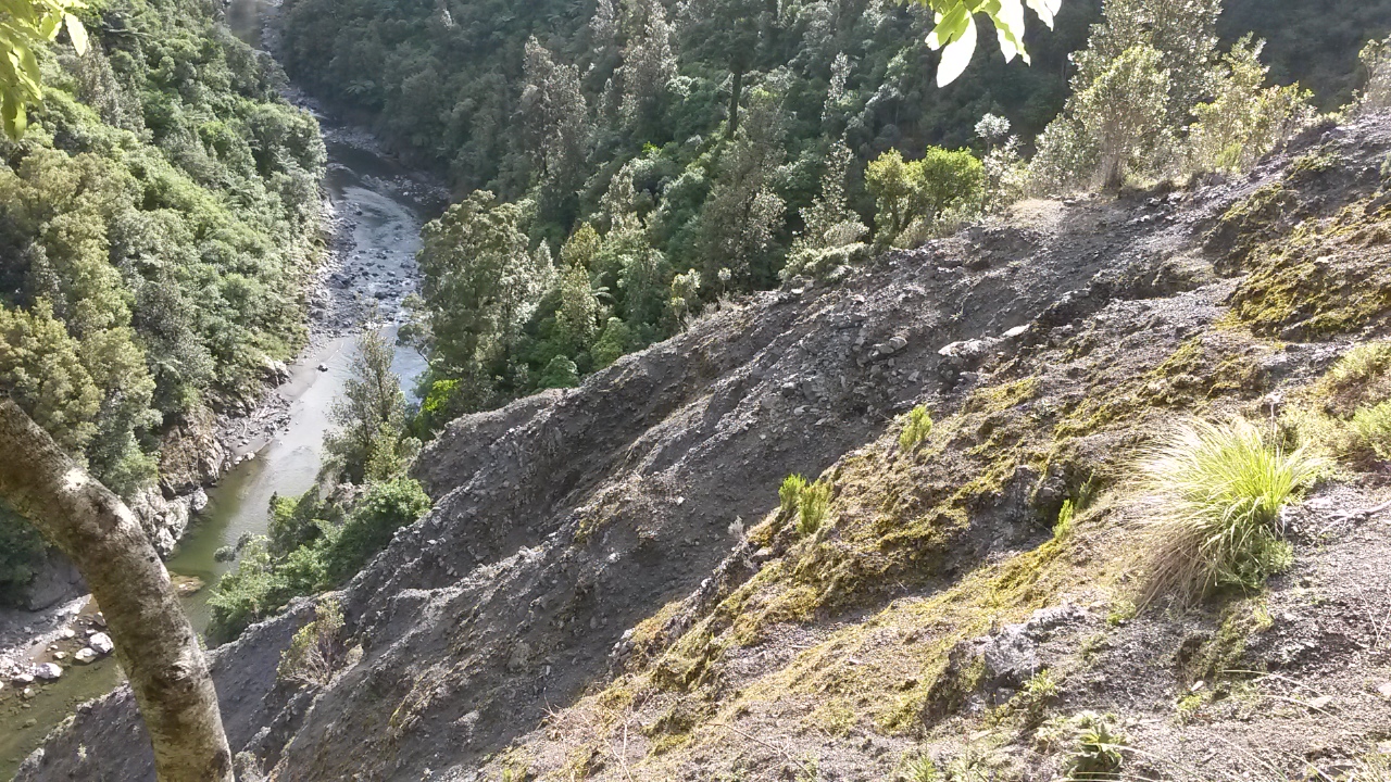
It starts well but soon gets a little messy with loose scree through the bush then steep clearings and finally an active slip. This section is a little tricky to follow and the slip is probably not for the faint hearted, but I see some rough handlines and make my way across to find the benched track again.
 |
| Down slip to the Otaki River |
After the first steep sidles, the track joins a terrace under mature forest (obvious on the map). This would likely be a bit of a bog at times but in the dry it is easy going. There are another couple of old slips at the end before joining another terrace.
Towards the end of this I think I might have drifted into following older markings as the track becomes rougher and eventually spits me out on the large slip around the stream from below Field Hut. I teeter across the face then assay a tricky scramble down into the stream thinking that during this process I will come across the track proper.
 |
| The big slip |
Nope - I find myself on a short stretch of stream between two waterfalls with the prospect of hairy scrambles out in all directions. On the clamber out I find an astelia in flower - looking like pink coral. Retracing my steps across and up the side of the slip then back to the previous stream I don't find any obvious signs of a bypass so drop to follow the river (much later I find that the old maps indicate the track goes up somewhere around here to go over the hill to Penn Creek).
It's almost 1000 - I've basically wasted an hour.
 |
| Astelia |
 |
| Waterfall I wisely didn't try to climb down |
It's very pleasant beside, and then in what proves to be a gently flowing Otaki. There are a few deep sections requiring some scrambling and the odd chest deep wade but all within my comfort zone. I identify Gorge Creek coming in on my left which recalls a very cold trip over Waitatapia 700 odd meters above.
Penn Creek is unmistakable (1050). A lone paradise duck complains at my presence from the boulder spit at the confluence. I am still thinking that the old track is somewhere on the face above (it probably isn't) but have my sights set further up river - which from here changes character to a wider, more bouldery proposition.
 |
| Penn Creek ahead |
Pt 148 is one of those odd spot heights on a river flat. There is absolutely nothing to distinguish it from its surroundings and illustrates that the heights were purely for cartography purposes and were not intended to indicate significant geographic features. It is nice to pick it off though as I had feared that it might be somewhat inaccessible. It looks like it could be a nice wee camping spot.
 |
| Pt 148 or thereabouts |
Shortly after, at 1140 there is an S bend that marks where I want to climb to Pakihore Ridge. It's steep with supple jack and undergrowth so is not a joyful experience. The climbing is steady though so progress is good once the understory opens out (I think around 520m). There is little to no trail until the ridge line, and even then it is not particularly strong.
 |
| Up river - from near base of spur Probably pt 668 behind |
Periodically the high pitched chipping of riflemans indicate they are checking out this interloper and one or two respond to my noises and come closer to investigate.
I join the track between the tops and Penn Creek at Pt 973 which proves to be an extremely pleasant spot for lunch (1410 - camembert and fruit bread). The ground is mossy and a gap in the low gnarled canopy has prompted a lawn of beech saplings to start racing for their chance. There's cloud on the ridges but sun breaking through here.
 |
| Lunch |
I watch the altimeter carefully as the track descends to identify where to drop onto the spur down to Pt 455. As it turns out the location is well identified with blue DOC markers bearing the warning "DOC bait line, do not follow". It's just before 1500.
The warning is not hollow as I end up following them too long without checking my compass. Consequently I find myself off the side of the spur with a long grovelly sidle through gullies packed with rotten logs and bush lawyer to regain the spur. The high points across the Otaki River (Waitatapia Ridge) provide handy points to triangulate and confirm when I am back on the straight and narrow. More blue triangles on the spur rub salt into the accumulated scrapes and bruises.

It still proves a little tricky getting down to 455 with the shape of the spur not always easy to follow. Approaching 455 I find an open understory with plenty of pig sign. It's around 1630.
 |
| Saplings growing from the root plate of a long fallen tree |
The next bit looks like it could be tricky as I don't really want to pop out on a slip or edge of a gorge. I cut SW off the spur finding a few tricky gullies full of undergrowth but eventually pop out on an old slip face - a sort of near vertical meadow now. Far below is a pretty little U bend in Penn Creek so I sit for a while in the baking afternoon sun (1510).
 |
| Eerie above Penn Creek |
The scramble across and over the next spur is straightforward and I find myself high above a wee creek. With a bit of scrambling it provides is a reasonable route down to Penn Creek itself, 20 minutes after leaving the slip.
 |
| Penn Creek - looking towards the spur to Vosseler |
It's a short wander up to the hut which is easily visible from the creek bed. It's empty and as hot as an oven.

The log book makes interesting reading with many entries from VUWTC maintenance trips (including marking the gorge route) and DOC pest control trips. One item that catches my eye is a DOC entry "Sorry - we shot the hut deer." It appears to have been a base for extensive pest control and monitoring which explains the plethora of blue triangles yesterday.
 |
| Sign by hut |
An intact pack of cards and a copy of the SK book provides some distraction as I eat dinner before turning in. Four goats are browsing the slip just down from the hut in the twilight.
Next morning I have a hot breakfast and coffee - i.e. a normal person's idea of tramping. The first order of business is to pick up spot height 554. I leave a little after 0700 and potter up stream to the first forks to hang a left. It's a lovely wee creek with some stunning swimming holes (if you use them don't forget this is the water source for the hut!).
 |
| First pool |
 |
| Second pool - a better proposition |
At the next forks (0745) a mossy wee creek of a completely different nature enters from the (not true) left - I follow up to a corner where there is (with a bit of luck) a bit of a spur to follow up. No sign of humans at this point but a few animal tracks and a bit of a trail at the top. The spur probably provides a reasonable, albeit steep in places, route up to McIntosh. I'm at pt 554 by 0830.
In the interests of variety I drop down to the other branch of the stream. It's a steep and unstable slope but goats have been through so it's a quick drop to the stream and a happy amble down jumping between boulders and over log jambs.
 |
| Some large boulders to clamber down |
 |
| Interesting rock - like melted ashphalt |
So far it has been a very pleasant morning and I'm probably a bit smug as I pause for a bite in the stream bed at the first junction (0940) before turning to the business of finding the target spur. I follow Penn Creek up to the spur with the marked track (the triangles are visible where it crosses the side creek from Penn Creek). My spur is just before this on - on the north side of the wee creek.
There's no apparent trail and a short flat section turns out to be a bit boggy but soon enough the long steep climb starts in earnest.
 |
| Weird yellow growth on tree |
I'm expecting to meet an old trail up from Penn Creek Hut but can't really swear to seeing anything more than animal trails and a very fresh pig wallow. Occasionally there seems to be something but it disappears and I don't see any old markers. It's the usual sort of open understory once you get above the lower slopes so no problems until the scrub starts.
Despite casting around I can't see any route and end up struggling through until I can cut right (north) around the slope to gain some open tussock - which provides some respite before the next belt of leatherwood.
Even on top of the main spur from Otaki River there is no apparent trail. The best option is to follow the tussock as much as possible and keep trudging until, somewhat battered and bloody, reaching the rounded dome of Table Top just before 1230. I haven't looked on the internet but I'm sure I recall that there is a route up somewhere - perhaps towards the south side of the spur?
 |
| Near top - view down Otaki River Waitatapia on right |
 |
| North to Waitatapia - Otaki River miles below |
 |
| From Tabletop - Judd Ridge runs up on right to Bridge Peak Main Range across the horizon |
At Field hut (1250) the shade and a bit of a sit down is welcome. There's a chap passing through to chat to as I fill in the log - noting that Harvey was through last week. He must have come through the day after me to do an interesting day loop via Rae Ridge - a nice trip with a bit of a clamber towards the top (Dennan).
With plenty of day left I figure that rather than pottering down Judd Ridge it might be interesting to drop into Sheridan Stream. There's some historic logging sites lower in the stream and on the map it looks quite navigable.
Tirotiro Knob (to which I have never paid any attention before) has one promising option but I elect for a spur dropping from the 700m contour further down the track.
It's a bit tricky finding the spur and sticking to it as it divides part way down - the bush is also a bit mixed with some kiekie and supplejack to contend with. However, I successfully navigate to the desired confluence arriving about 1445.
Sheridan is another lovely wee creek and it's pretty good going. A couple of paradise ducks get a hell of a fright as I galumph around a corner and fly up and down the narrow valley complaining for quite a while before I leave their range.
Towards the lower reaches (I'm not paying any attention to the map but it's a little after 1530), there's a wee water fall into a pool between two steep rock faces. The only way through would be a plunge and short swim which I don't fancy.
A scramble up the bank on the true left to get over the wee bluff to my surprise deposits me on a railway track complete with sleepers and rails. It disappears pretty quickly but from here on there are periodic sections of track with DOC triangles and I'm in and out of the creek. I don't identify the mill site itself but could have stumbled through it without noticing.
 |
| All aboard |

I meander across the flats to cross the river to the campsite and a dry walk back to the carpark (1700) past visibly wilting saplings on the road margins.
The trip has left me somewhat bruised and battered but well pleased with the weekend's explorations. The bush is tinder dry from the lack of rain with kidney ferns and moss turning crispy. In places, the forest floor is covered in drifts of golden leaves shed by stressed trees - more like an English forest in autumn than New Zealand bush.


