It starts with three orphaned spot-heights on the steep and unfashionable slopes above the mid Waiohine River. How on earth do you link them up and make a semi credible trip?
With a day or two mulling, a few other features I've been meaning to have a look at come back to mind; that aircraft wreck on Shingle Slip Knob, Francis Creek, some spot-heights around Angle Knob and a couple just off the Gentle Annie track.
The only way to string them together involves a fair amount of up and down and a night out. That's not so bad - what is bad is having to book a bed in a hut for the first time (not really complaining - just mildly put out that I have to go through the 'front country' to get to the back country).
What: Nav trip, spot-heighting and disaster voyeurism
Where: Francis Creek, Shingle Slip Knob and surrounds
When: 9-11 March 2018
Who: Solo
Map:

 |
| Closer view of the interesting bits |
Train home, chuck stuff in the car, stop for petrol, then again for a kebab in Carterton - finally departing the road end on a soggy Friday night at 8.45pm. Dark already - it must be autumn. Also quite cool - the sou-easter is bringing some pretty chilly air after a hot summer.
The first order of the night is to pick up spot-height 412 - on a wee lump at the bottom of the Gentle Annie. A doddle in daylight and pretty straight forward in the dark, but for a bit of compass trouble (never did work out what was wrong with it - maybe lingering affects from the magnet last week?). There are some foot trails along the top of the lump and lots of pest control tracks around it, but I find a way to exit through a swamp and supple jack.
A bit out of sorts, I resume the walk up through mist. The next spot-height (801) is somewhat easier - I locate a foot trail leaving the main track and it's pretty easy to follow up to a flat top among dripping trees. Here there is an intersection of old ways. Clearly the main track from the carpark to Mt Holdsworth used to come up the spur line, and Carrington Ridge, which heads south from here, must have had a track back in the day (no longer marked on the map).
The first order of the night is to pick up spot-height 412 - on a wee lump at the bottom of the Gentle Annie. A doddle in daylight and pretty straight forward in the dark, but for a bit of compass trouble (never did work out what was wrong with it - maybe lingering affects from the magnet last week?). There are some foot trails along the top of the lump and lots of pest control tracks around it, but I find a way to exit through a swamp and supple jack.
A bit out of sorts, I resume the walk up through mist. The next spot-height (801) is somewhat easier - I locate a foot trail leaving the main track and it's pretty easy to follow up to a flat top among dripping trees. Here there is an intersection of old ways. Clearly the main track from the carpark to Mt Holdsworth used to come up the spur line, and Carrington Ridge, which heads south from here, must have had a track back in the day (no longer marked on the map).

With the evening's entertainment dealt with and my watch showing 1040 I settle down to the serious business of getting to my bed for the night.
An hour later, Powell hut is showing a light as it emerges from the clag. A group is playing cards and I leave them to it in favour of crawling into bed. The hut is under half full so I probably didn't need to book.
In the morning the view is grey with a few breaks in the clag showing that the Wairarapa is clear. The unpleasant prospect of dragging on damp clothes and getting out means it is 0740 before I finally get away.
It stays claggy until after Mt Holdsworth when there are a few breaks to the east. It doesn't help me so much as I am looking for the start of a spur running nor-west. And it is on the boundary between two maps (my own fault - I forgot to do a printout overlapping the two).
 |
| A brief respite - the clag lifts |
It turns out to be pretty easy - just after the East Holdsworth Track turnoff I take a bearing and the spur soon emerges ahead. It's about 0830 as I start to make my way down and quickly drop below the clag. There's little or no ground trail but when I reach it, the scrub is not too bad with a quick transition into stunted forest.
 |
| The spur starts to emerge |
Spurs are pretty much spurs, but this one is quite entertaining. It drops steeply with a number of knobs and little turns that you don't want to miss (or don't want to take by mistake). A stream to the south is a constant companion with some pretty waterfalls, and getting quite substantial by the bottom. The trick is to keep it close on the left but don't drift onto any side spurs that would drop rapidly into the water course. The spur top is often sharp with drops on each side, and towards the bottom requires some steep clambering.
The odd glimpse through the canopy shows steep faces on all sides particularly across Francis Creek where I will be trying to find a route up. What the map says is born out - there are some impossibly steep faces if you try to climb in the wrong place.
A little after 10 I'm standing by Francis Creek - it's a good size with large boulders and log jambs. The creek that has shadowed my way down is also no slouch - the two come together in a cascade and drop rapidly down the narrow valley.
 |
| Forks on Francis Creek |
From the map, I've figured that the best access up the opposite side is downstream of the forks to (hopefully) find a way out of the creek and up to a spur running NNW to pt 1120. That's pretty much how it goes, barring the sweating and swearing.
I head down stream a few hundred meters and stop for a bite before tackling the climb. What with admiring the scenery, refilling water, losing a few layers and a bit of a sit down, half an hour has passed.

On the lower slopes a flock of Whiteheads come down to scold me which attracts a Piwakawaka who performs his wero a few feet from my face. A little later two Riflemans come just as close - closer than I have experienced before.
There are a few windows out to clouds on the tops and the surrounding slopes. I play the inevitable game of trying to label the features. To the west, Francis Creek drops to the Waiohine - on it's true left is the spur I came up a few weeks back to Isabella and (when the clag lifts) Holdsworth to the south of where I'm standing. The main range forms the eastern horizon and I pick out where Anderson's hut is, the bushy saddle to Kahiwiroa with my spur from the previous trip, and Aokaparangi further south. But this isn't getting me up the hill.
 |
| Spur from Francis stream to Isabella from a week or two back |
There's a bit of a scramble through scrub before getting into the tussock but not too bad. I find a good animal trail angling up the west face of the spur and avoiding the top of the first knob. It takes me to flat section on the spur then it's pretty good going to 1412. At 12.50 it's taken over two hours to get up from the creek.
 |
| Looking up spur to 1412 with Angle Knob in cloud |
 |
| From 1412, Angle Knob gets more cloudy |
 |
| Spur to McGregor Biv in mid ground |
The cloud ceiling is high enough that the ridge to Shingle Slip Knob is clear. There is a bit of ground trail on the narrow sections but a lot of the top is broad and the trail is easily lost. It's not far though.
At the top, a couple of crosses stand in the tussock a little to the north, marking where the flight crew are buried. They are dwarfed by the landscape and the grey aluminium matches the grey sky.
The back of the crosses have large eroded sections where the grain of the aluminium is visible - I assume this is from ice forming and breaking the surface.


From the ridge-top the tail section of the plane is clearly visible a little way down slope. I sit and have lunch over-looking the scene before working along further and finding a foot trail dropping down the face.
The plane was apparently on a training flight from Ohakea and crashed in poor conditions on the way back. The wreckage was found three days later with the two dead crew (further info).
 |
| Tail section |

This is the most intact of the four planes I have seen in the ranges (honestly I am not a plane crash voyeur). It looks like the plane hit with an uphill trajectory and, because there were no trees, it has not broken up as much as others, and the pieces are more visible in the open.
It is also possible that the pieces have been moved - some material was removed from the site in 2009 for display but the culprits had to put them back. One can also imagine that over 60 years of the Tararua wind fatiguing loose metal will be whittling it away.
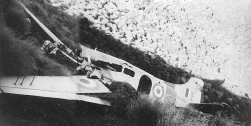
Approaching the site, more pieces of wreckage become apparent. From one angle you can almost see the shape of the plane with a wing, the tail and the front section in approximate relationship. An original photo of the crash indicates that there used to be more of the fuselage present, and the presence of a RNZAF paint scheme long since stripped off by the weather.

 |
| Bent and broken propeller |
 |
| The remains of the cockpit |


The work now is to get around the slope and study the spur that runs NNW swinging to NW and eventually dropping to pt 736. As always it would have been easier to go back to the top of the hill - but I'll probably never learn.
After dropping into the bush it is a little hard to find the spur, but it soon forms and drops quickly at first with little shape then more gently with a broad top. It's a wee while along the almost flat top and time to keep company with a goat that scoots ahead for a while. And once a deer barks from somewhere off to the side. The going gets tricky at 1000m where I need to head of in a different direction and there is little shape to the hillside.
A noise from ahead indicates a deer is starting to make tracks - he stops when I stop and we look at each other for a good minute from about 40m away. I must be down wind as he wrinkles his nose but doesn't move - even when I make a poor imitation of a deer bark. Eventually he moves off but stops again, his antlers just visible through the trees. I'm the first to get bored and head off in the wrong direction for my spot height. He grunts loudly at my retreating back and we exchange 'roars' for a while (by roar I mean guttural sounds like a very large man with indigestion trying to burb past mash potatoes caught in his wind-pipe).
Eventually I sort myself out and head in the correct direction to take a bit of a break on the knob at 736. The map shows a bit of a gully running north from here to a stream where I can cross to the next spur north. I figure it looks the most navigable route and it turns out to be pretty good - a lot to do with the number of animal trails.
By the time I get to the bottom, my gully is carrying a sizable wee cataract (but not marked on the map). The stream I meet is bigger.
 |
| My unmarked side stream |
I drink my fill and top up my camel back. This will have to do until tomorrow lunchtime unless I fancy tarn water.
The next section promises to be a bit of a gut buster. And judging by the map the best route starts right here. Across the stream there's the foot of a sharp spur - to my surprise there is a stream on the other side and the first few hundred meters the way is very narrow with sharp drops on both sides (the true right stream is smaller and not marked on the map).
After this, it is just a steady, steep climb with nothing but animal trails to follow. I wander a bit off the south of the spur at one point into some quite nasty country (logs, scrub, bush lawyer) and find myself following a wee stream on what seems to be the face of a broad spur. I take advantage and drink my fill again.
The day has cleared and the afternoon sun is angling in under the canopy, almost drying my soggy gear. I am of half a mind to push for the top and make a go for Jumbo hut to arrive in the dark - the less gung-ho half is intending to stick to the plan and keeps half an eye out for spots to fly camp. Not so likely on this part of the hill.
By the time I roll over the top of 1145 (7th and last spot-height for the trip) it's 5.45 and the sensible half has decided I am most definitely looking for a tent site. The top is open and mossy but also somewhat boggy. I head for a flat spot before the saddle on the grounds that it might be a little more sheltered. By taking the sensible option I now have plenty of light to select the best site and pitch the fly - at which I am still not very practiced (the fly is quite narrow so a bit unforgiving if it is slightly out of alignment).
I dump damp clothes and don every layer I have, before climbing into my bag to cook dinner. The evening sun is just clearing the main range to line the mossy trunks with gold.
 |
| Comfy? |
I wake before dawn and pack in the hope that I might beat the sun to the tops. Getting away at 0700 it is already dipping the tops of the main range behind me before I reach the bushline. But I do manage to get to the tops before it clears the saddle by Angle Knob.
There is a bit of ground trail through the saddle and on the climb I find a barrel covered in plastic with a spade next to it and a cairn nearby. I assume a hunter's stash. At the bushline there is a bit of scrub but it is a remarkably kind transition to the tops.
 |
| Dawn on the main range High point is Mt Crawford, Nichols hut invisible on right, Anderson's Memorial hut behind lump on left |
Free of the bush I can see the shadow creeping down the slopes of the main range. I can also just make out Nichols Hut which stays in shade for a remarkably long time.
On the way to the top I pass the face that gives Shingle Slip Knob it's name - a big chute on the NW face funnels broken rock down a gully into the head waters of the stream I crossed yesterday afternoon. Rounding the shoulder of the Knob, the sun breaks the horizon and the shadow of the ridge races down slope past my feet.

Back at the top of the Knob and I am retracing my steps for the first time in the trip. The grave markers strike a markedly different tone in the morning light.

 |
| South west down main range - Kapakapanui on horizon at right |
I make a slightly better job of following a ground trail but lose it on the climb to 1412. Progress is somewhat slowed by the frequent stops to gaze at the views - again, the game is to identify the high points on the main range, Carkeek Ridge, Dorset Ridge, the spur with MacGregor biv...
 |
| View north - into the headwaters of the Waiohine |
 |
| View south - Isabella on right next to Holdsworth my spur from Francis running down from left |
 |
| View back down ridge to Shingle Slip Knob |
 |
| Angle Knob - yet to see the sun |
 |
| My spur again with Holdsworth beyond |
After 1412 it is cool in the shadow of Angle Knob. The sharks teeth on the ridge look a bit daunting but the north side is quite navigable with a bit of a trail that (if you keep your eyes peeled) threads the needle with out too much exposure. The odd cairn shows an easier path.
Just before 0900 I climb over the shoulder, into the sun, and onto the top of Angle Knob (1510m). I'm enjoying the view and taking a few photos when I hear voices - a couple of chaps have arrived from the more approachable east side. One of them recognises me from a trip some months back when we met at Waitewaewae hut on the way out to Otaki Forks. They are on a VUWTC trip doing the loop via Broken Axe Pinnacles and Baldy having spent the night at Jumbo hut.
We chat for a bit then I head along the ridge to Jumbo passing the rest of their party on the way.
 |
| North from Angle Knob - Ridge to MacGregor in foreground |
Along the ridge I notice that there is ice on the trail - no wonder it was a bit chilly last night. With the conditions and broad trail I can make good pace and am soon at Jumbo where I meet a party of five that had been at Jumbo Hut - I suspect I would have been sleeping on the floor if I had come through last night.
They are heading for Holdsworth so I slip ahead and trot south along the ridge - meeting three or four parties coming the other way. There are frequent reasons to stop and look across the valley to Shingle Slip Knob. The shadows on the spurs give the valley the look of elephant hide. Once Shingle is in sight the plane stands out - a shining spot near the top of the Knob.
 |
| Across Francis Creek valley - my spur up on left |
At 1015 I'm looking down my spur of yesterday morning with no clag - completely unmissable - don't know what all the fuss was about. Turning east I start the sharp descent to the Atiwhakatu valley.
The track is easy to follow and, beyond a few pauses to drop layers, it is an uneventful trip down. There is one point worth noting for future reference - shortly below the bushline an old marker has 'water' scratched on it and a stream is audible just to the south of the spur. I assume this is the point on the map where this is a pronounced kink in the creek.
 |
| From near top of East Holdsworth Track Nichols (or Crawford?) on left, then spur up to Shingle, then my spur up, then Angle near centre |
The day is heating up so it's good to be under the canopy. There's a bit of windfall and some missing markers indicating that the track is not quite as maintained as the Holdsworth circuit, but that's no bad thing. It's over an hour to the bottom where the wide graveled track offers faster travel and rest for weary knees.
It is also where I run into serious traffic - a multitude of families with dogs are heading up valley. I jog where I can taking about half an hour to arrive at the carpark at 1205. Looking at the map it feels like a reasonable half day effort.
Postscript
A really satisfying trip. The spur down to Francis Creek is a wonderful little diversion, and the creek itself is impressive. The spur up is a grunt but the tops are well rewarding as you are surrounded by peaks and ranges. The wreckage is interesting for those that like that sort of thing - certainly an important part of the history of the Tararuas. Getting to 736 and 1145 was a worthy challenge of navigation skills and stamina, and the night out on 1145 was a surprising pleasure.And seven more spot-heights ticked off.


