Showing posts with label makaretu stream. Show all posts

Saturday, 3 November 2018

Makaretu and Te Araroa

Perusing the map for weekend possibilities I'm surprised to find what looks like a new chunk of Forest Park. It's possible it was always there and I missed it - it's also possible that its status changed and someone got around to updating the map. Anyway - it has six spot heights and it looks fiendish to navigate - flat and with possibly pretty marginal bush.

It looks like a challenging day or overnighter so I figure to also pick up a cluster of four spots in the foothills behind Levin where Te Araroa briefly exits the bush before heading up to the Main Range. These were a step too far on a previous day trip.

Oh yeah - and the weather forecast is rubbish. The are no rivers but a couple of the streams could get gnarly.


What:     Navigation and spot heighting weekend trip
Where:   Makahika and Makaretu
When:    3 - 4 November 2018
Who:      Solo
Map:


Makahika - around and off Te Araroa 


The wipers are on for most of the drive up, but at least the Waikanae bakery is open for breakfast. There's a very old and battered camper van by the style as I leave the car at 8am. Someone slept here last night judging by the chock under the front wheel - no sign whether they are in residence or not at the moment. I head of across the farm land under steady rain.


Last time through was by headlight (also in the rain) - distances are shorter and I smile at seeing how close to the trail I was when I staggered into a pool full of farm rubbish. The stream crossing I was worried about is a non-event although not as high today.

There's a bit of stock about and a pair of paradise ducks take more umbrage than my presence surely warrants.


A wee camping spot with a long drop marks where the trail starts its transition into the quiet of the bush. It's very pretty here with some lovely groves of ponga. The old tramway is a great platform for the track as it meanders back and forward across the stream. Water drips through the canopy but down here the weather becomes a secondary consideration.

It's the usual challenge to find where to leave the stream and hive up to the first spot height (293). Once on the spur there's a trail with old tape markers which I didn't expect to see - I overshoot the spot height to be sure I've passed it then drop to scramble down a stream to the track.

Where the track crosses the watershed between the Makahika and Mangaore Streams is my signal to follow a stream north and down (pretty good going - no tricky gorges).

The Mangaore is discoloured and up but not an issue. The climb onto the next spur is a bit steep though. I don't see any markers but further up there is a light trail that misses the worst of the supplejack. The odd rewarewa flower on the ground or growing like dark red coral from a black trunk give a clue to the specie of some of the trees. The rain keeps raining.

At 493 the forest looks like every other bit - it's 11am and two down for the day.


493

I blunder back down drifting off the spur a couple of times on the way, then dropping further upstream in an effort to miss the steepest bit (successful). The Mangaore is as brown as before. It keeps raining.

A short way downstream a wee cascade marks the point to start another steep scramble which eases up to 371 - near the top another taped trail crosses my path. I strike a different line down to pick up the track again and start heading out.

As I climb to 370 I'm not 100% sure I'm in the right place (a familiar feeling throughout this weekend). The top is broad, flat and generously supplied with supple jack (also to be familiar). I nominate a lump and call it 370 and take a bearing to get out. If I'm in the wrong place it will drop steadily to a stream; if I'm right I will follow a gentle ridge down into scrub.

I blunder onto another taped track - this one looks like an old logging trail - it's quick going and there are a lot of foot prints. It descends as gently as hoped.

Just as clearings start to appear the tapes head off to the left and start descending - this suits me fine as I suspect there would have been serious gorse ahead.

I lose the trail towards the bottom but the vegetation stays ungorse like. I wade across the stream and join the trail again at the camping spot at the edge of the bush. A fresh set of prints show someone has walked out since I came in - probably slightly unhinged to be out in this weather.

It's 2pm, the campervan is gone, as are the first four spot heights.

The area has better bush than I expected. There are lots of informal trails and plenty of opportunity to wander about off track. No views to speak of though.

Makaretu - tricky navigation and supplejack


With the weather forecast as rubbish as it is, the troop needs some encouraging not to stay in the car and just keep driving for home. Common sense is confined to the glove box and I turn off at Poads Road.

The park by the narrow bridge has the scattering of "bourbon 'n cola" cans associated with the sort of place you don't want to leave your car.

It's almost 2.40pm as I head for Makaretu Stream - overnight-pack sitting comfortably (and more heavily) on my back. The stream is usually no problem but it will be up today and I'm not sure if the gorgy bit will be passable. However, although it is flowing fast and discoloured, a river stick helps with the myriad crossings and there is only one cascade which has me temporarily stumped. (I find a taped route on the way out which bypasses most of the sketchy bit).

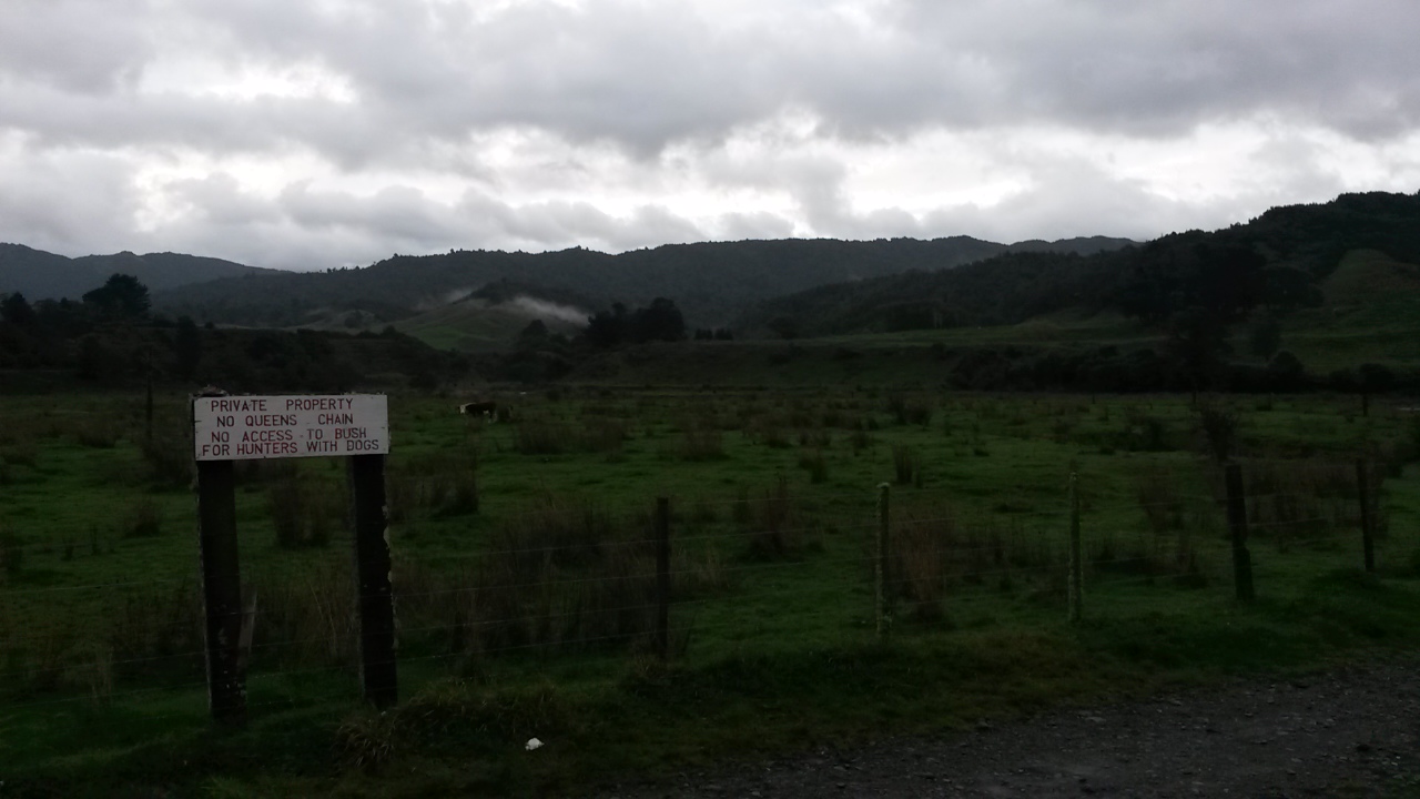
The stream route is the way I've been before but it is across private land with a sign warning off hunters (to little apparent affect). I think there must be other access points but haven't investigated. The block of land is the toe of a long ridge that runs into the depths of tiger country. Lots of informal routes but no DOC tracks. With the area regenerating from logging and farming there are flats by the Makaretu stream and clearings that attract hunters.


At 3.15pm I'm at my side stream. A short scramble up and I'm confronted by a 5m waterfall. The pool at the bottom is ale brown with a foam head to match. The true left is impassable so I find a way to clamber up a sharp spur on the true right to rejoin the stream higher up.


The stream is well worth an explore - there are terraces with an old tram route and a good track. I reluctantly leave it to follow a wee stream up to the 'plateau' (not strictly a plateau but relatively flat for the Tararuas).

Not for the last time I know I am in one of two places and little to tell which. It's mucky work following the creek and the top end is choked with rotten logs and supple jack. I work my way up to what I think is point 314 - there are no views and I can't swear I'm not at 311. There is another marked route though.

The bush up here is mixed - lots of ponga groves, some rimu and other tall emergent but mostly mixed forest species in the process of recovering from old clearance. The understory varies from ambling easily over ponga fronds to scrambling over rotten trunks or tangling through vines.

Navigation becomes a series of questions - if I'm here and go in that direction I will see the land do this and if I'm in the wrong place I will see it do that. The land keeps doing 'this' until I get to what I think is 311 by which stage it is getting dim. Meanwhile, the rain rains.

I get a bit muddled after 311 and decide to work it all out in the morning. My chosen spot for the night is on a flat area near a trickle. I find a log and pitch the fly against it, scattering some dry ponga fronds - more for effect than padding.

It rains heavily during the night - I manage to keep dry and try not to think about what may crawl out of the log and into my sleeping bag.

In the morning the rain has stopped but I can't see the sky yet so the jury is out on the weather. The plan is to head norwest to get to the edge of the plateau (and hopefully a view) then follow the edge upwards to the next spot. I drag on sopping clothes and head off about 8.20am.


Home ...

I cross a few other ribboned trails on the way and drop in and out of gullies that may or may not have been on the map. It's all very confusing but eventually my route starts climbing as expected and I figure I have got to 370 (9.30am). There's a well formed track nearby which takes me quickly to a marked clearing and finally I can confidently say I know where I am and I was always around about where I thought I was (if you follow me).

I suspect the trail I found would take you up to Panatawaewae if you were of a mind.

The clearings turn out to be old pasture slowly being eaten by the bush. Pigs evidently find them a good source of nourishment. The day has even got the odd bit of sunlight going on.


Looking back - 370 on the left.


The next spot (415) is going to be a challenge. The land forms are confused and it looks indistinguishable. I reckon I can find it if I sidle along the slope for a while then pop up to the low ridge. It's a bit tricky but this is pretty much what happens - apart from a few false starts and a bit of clambering across unexpected gullies.


There's plenty more opportunities to get involved with supplejack


From 415 there are two spots to go. They are on the way out and are on an intriguing looking ridge.

My bearing takes me towards a creek but I immediately blunder into more tape which is going in approximately the right direction so I follow it. In retrospect, when I finally lost it, I strayed right and dropped into the wrong creek. I find myself sitting at a junction of two streams working out that I am at one of two quite different spots (again).

The choice is simple - climb the hill on the right or the left? I think it is the left - it also happens to be gentler and will more quickly tell me if I'm right or wrong.

Back on the correct ridge I find more markings - possibly the track I lost earlier. In this manner I find myself pottering along a narrow top with a stream in a gully below on each side. I also cross the next spot height (295) and head for the final for the weekend (280).

It feels like the end is in sight - it's a long straight ridge and pretty good going. The trail becomes very well established with a lot of marking and all the indications of having been cleared at various times in the past.  There are at least a couple of points where you could drop norwest into the unnamed stream I came up yesterday.

As the ridge starts dropping the track heads left and I want to go right (1.20pm). There's no trail but it's a pretty straight forward scramble down to a large terrace above Makaretu Stream, and another track.

I'm back at the mouth of the unnamed stream at 1.45pm. The Makeretu is still up but running clearer.


Entrance to unnamed stream

I keep my eyes open on the way down and find some interesting tracks on terraces on the left. Including a long diversion which leads up to the edge of farmland and skips the cascade. I find a way back down to the stream and follow it back across the farmed flats. The day has continued fine but windy. It takes about the same time to get back to the car (40ish minutes) but a lot easier than the trip up stream.

Postscript 

The only thing left to report is that, aside from 10 spot heights down (and 73 to go), myriad informal tracks and trails, and heaps of polythene left by hunters - I stumbled on a hut. I'd heard tell of a ponga hut somewhere in the northern Tararuas but never thought about trying to find it.

There's a few references on the intranet but I couldn't find one with a location - so I'm not 100% sure this is the same one. I'll not make it too easy - if you want to retrace my route (bearing in mind that a chunk of it is estimated on the map) you might find it. Or if I know you I'm happy to divulge.

There's carpet on the dirt floor, plastic walls, some ponga posts and wall cladding, tin roof, potbelly with chimney, a long drop, a bench outside, even old sleeping bags on the beds ... It's rough but dry and comfortable inside.


Wasn't expecting this ....


"The Ponga Whare"


Saturday, 12 May 2018

Makaretu Stream and Spion Kop

Call it confirmation bias, wishful thinking, stag fever, pattern matching ... our minds are easily fooled into seeing what we want (or are expecting) to see. I must have been a bit absent minded this weekend as I manage to illustrate a number of examples of this particular cognitive failure.

The first example of bias is wishful thinking - in this case looking at the map and hopelessly overestimating how much distance I will cover in a day.  I had been thinking to get into the Otaki headwaters before dark, but in the end sundown catches me at Lake Hollow on Oriwa.

As a result of this and the weather, the intended spot-height bagging returns a net score of nil. I do however visit Spion Kop (which sounds far more intriguing than it actually is) and circumnavigate the catchment of the Makaretu Stream.

According to Wikipedia, Spion Kop was the site of a battle in the second Boer War which was won by the Boers. It took place from 23-24 January 1900. Wikipedia is not so forth coming as to why the name has been attached to an obscure knob on the edge of marginal farmland in the Horowhenua.


What:    Navigation trip
Where:  Spion Kop and Makaretu Stream
When:   12-13 May 2018
Who:     Solo
Maps:

Large scale view

Start and end bits

Middle bits

The trip up the coast is punctuated by a successful foray off the express way to the Olde Beach Bakery - highly recommended purveyors of delicious baked products.

I had been intending to head out to Tangimoana Road to take a farm track up to Spion Kop (marked on the topo map), unfortunately the land owner there is less than obliging so that's off the cards. Instead, I follow Poads Road to the end and bump into the leaseholder in those parts as he is heading out with a boot full of chainsaws. He indicates that the land by the mouth of Makaretu stream has a new leasee but it should be ok to follow the stream bed.

I park by the bridge (next to the sign that says there is no Queen's chain) and at 0750 leave the car with a little bit of trepidation. This spot is a bit more visible and I wonder if it will still be in one piece on my return.


Car park

There's space between the fence and the river to walk to reach the stream - which is quite a good size (and a little up). The paddocks soon give way to bushy banks and a gorge, however the bottom is generally wide enough that there is only a couple of scrambles to avoid deep bits. There's a few terraces and flats with lots of lovely punga.


In the gorge

A little over 2 hours later I reach the flats. There's an initial false alarm (a small open area before diving back into a narrow section) before reaching a long series of flats with lots of cutty grass. It's generally pretty good going although you can get mired in the grass if you pick the wrong line. I discover that it is fairly easy to miss the side streams which is a little bit tricky when you are trying to navigate by them.

About 25 minutes up from the start of the flats there's a(nother bloody) hunters' camp on the true left. It looks like it got a lot of use once but is now just a pile of litter, like most of these structures.  I think this one might be near an old route to the ridge above Spion Kop, but I have my eye on a spur further up.


Hunters' rubbish


The flats - Panatewaewae to right of centre (probably)

There's another camp about 15 minutes later in a similar state and 10 minutes after that (about 1050) I just about miss my stream as it flows out between clumps of cutty grass.


Another camp

It's a bit of scramble onto the base of the spur with no signs of tracks. It's relatively young forest - lots of slippery black humus and healthy fungus but open enough. A little over an hour later (1100) I emerge on the ridge top to find a good ground trail with old orange spray blazes. I follow this down to the edge of the farm land where it pops out onto a grassy knoll with a survey pipe by an old farm track. The track leads down to a series of little knobs - one of which is Spion Kop (about 12.30).


Not Spion Kop but it does have feet


Magnificent vista from Spion Kop (I think)

The cloud ceiling is about 1500m so it's a bit of a gloomy view to look at while I have a bite. The farm here consists of a narrow strip of land around the tops of the spurs - there's a few cattle beasts about. 

Back in the bush it's getting cool and the wind is coming up. The track leads nicely up to Panatawaewae where the markings finish and the trail becomes far less distinct.  There are only two spots though where the compass is needed - both where the ridge drops into a saddle. The bush up here is reasonably mature with some windfall to contend with. I assume it is largely regrowth following logging and the 1936 storm.

For some reason I'm feeling a bit tired so stop for a breather - after which I set off purposefully in the direction from whence I had come. This could possibly be characterised as some sort of bias, but I think it is more an example of some sort of stupid. Fortunately I twig before I've gone too far.

It's taken a lot longer than I had thought to get this far so, by the time I reach the ridge junction south of 890 I've decided I won't be dropping into the Otaki headwaters tonight. Depending on progress from here I will either stay near the top of Oriwa (Lake Hollow where this is a roof with a water tank and plenty of camping spots) or maybe pop through to Waiopehu hut.


Look, a marker - this must be a track ...

I have been along this part of the ridge twice before - both times finding it easy to get mislaid in the flattish, swampy bit just south of the junction point. It's 1530 and fairly cool but not raining. There's a few old plastic markers but little ground trail until the ridge top sharpens on the stretch towards 918.

The drop to the saddle is a little tricky - it's the sort of place you would expect to see a useful marker because people must come through here. I don't notice anything and overshoot slightly, following what turns out to be another one of those ubiquitous disappearing game trails (another example of bias?).

A bit of a scramble brings me back onto a better formed spur with occasional wee windows down Makaretu Stream, it's about 1610.  I suspect the trick through this saddle is to keep close to the north face and follow the spur NE into the saddle then grab one of the two sketchy spurs that head SE up to Oriwa and Lake Hollow (I think I follow the later and can't say there is a significant ground trail).


Makaretu Stream

The bush is quite mixed through the saddle but ends up with a climb through reasonably open trunks chasing shafts of burnt orange sunset up the hill. At 1710 I'm at the ridge top seeing the last of the sun dip below the horizon beneath a lowering sky.


Lake Hollow in the last of the light


A roof without a hut
(second time my only photo here has been rubbish)

Lake hollow is as soggy as usual, I pause to clear the guttering on the roof then get a move on to make the most of the rapidly fading light - sights firmly set on a dry hut for the expected overnight southerly rain.

There are a few tape markers and a reasonable ground trail but both rapidly become invisible in the gloom. The ridge is well formed and, following the compass, I manage to keep to a line, although frequently wander off and end up clambering through more tree falls than you would in daylight.

The wind rises and it starts getting quite cold - the odd piece of orange tape is a welcome confirmation of progress.

Finally, the ridge starts climbing steeply and the trees give way to leatherwood before the canopy disappears completely. The open sky swallows the headlight and this lone tramper suddenly feels a lot more exposed and vulnerable. Shortly afterwards I lose the trail in the tussock and thrash around the slope expecting to drop onto the track at any moment.

Here the dreaded bias comes back into play - when I eventually reach the track it is running at an unexpected angle - my brain runs a convincing argument that the only way it would be running in this direction is that I crossed it at some point and have circled back. Full of confidence I turn in the wrong direction and head off  thinking that the lights on my left (probably Palmerston North) are Levin. Ironically, this direction is taking me to  Twin Peaks - the site of a memorial to some trampers that died in that storm of 1936.

The track drops and then starts climbing - finally my brain accumulates enough dissonant feedback to suggest that we stop and regroup. The compass seems to be pointing in the wrong direction and I can see a light behind me. I think the light must be the hut but taking a bearing on it makes no sense whatsoever (it was probably around Lake Hollow but I didn't see anyone there when I came through). Finally - trusting the compass and the line of the track, and applying some logic (the muddy track has such high use it can only be the main thoroughfare) I turn around and trudge back into the saddle and up to Waiopehu to finally drop down to the hut.

At 1930 I came in from the cold to be met by candlelight and a growling dog. A party of three (plus dog) are retiree friends who came in Wednesday aiming for a northern crossing but wisely turning back with poor weather on the tops. The two women have turned in but the chap obligingly heats water while I slough off wet and muddy kit. 

Things are decidedly more cheerful in dry clothes and with a full stomach. My hut companions are reasonably quiet (once the dog settles down).

For the record - although the dog was reasonably well behaved I am still of the view that dogs don't belong in huts. I'm not about to start an argument though so keep my thoughts to myself.

The rain starts in the early hours of the morning and keeps a steady blatter against the windows - in the morning it transpires that it is driving straight into the porch so some of the things left to dry are not as dry as hoped. The dog takes one look outside and decides it can hold on a bit longer.

As usual, my brain has come to some conclusions during the night - in this case, that we won't drop down a spur to what might be a swollen Makaretu Stream so the most practical exit is straight down the track.

I'm first out at about 0800 - it's raining but not windy and the cloud ceiling is a good 100m higher than the ridge. The track itself is alternately a bog and a stream stream, but once under the canopy I warm up and soon shed gloves and balaclava and start regretting the merino layer.


Morning

It gets quite dim under the canopy but the rain stops and it's nice to potter down through the wet bush.

The rest of the trip? Not much to report really - the intersection with 6 discs track at 0930; the bottom of the spur about 1010. The paradise ducks set up their habitual racket as I wander across the farm flats to arrive at the usual road end at 1020. 10 minutes later I'm reunited with the car, which I'm delighted to find in one piece.


6 discs intersection

Postscript

Not all boxes ticked but some new countryside and a satisfying wee explore. Makaretu is worth a look but watch for hunters and be careful about access. The Otaki headwaters are still very much unfinished business - unfortunately there is now one less unexplored route to get there.

Nil spot-heights for the weekend? Oh yeah - the rules (more like guidelines really) are that only spot-heights in the forest park count - most of this trip was actually outside the park boundaries or covered points I've already been.