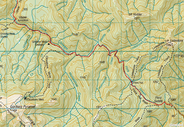
There are plenty of MTB opportunities around Nelson but I'm looking for an interesting through or loop trip and not a MTB park or tourist trail. It pays to share such weighty decisions with your colleagues because someone suggests Barron's Flat track. I was dimly aware of but hadn't really registered it as a possibility.
There's a bit of info on the DOC website and various MTB sites which all point to it being just what I'm looking for.
What: MTB trip
Where: Kahurangi National Park - Mt Arthur area
When: 21 January 2018
Who: Solo
Map:
 |
| Barron's track |
The 3am ferry is always an interesting start to a weekend - not really recommended though as it takes a fair chunk of time out compared to flying. However, it's a good chance to pick up with Iona, Vicki and Alistair in Blenhiem. The rest of Saturday is spent snoozing with the air conditioning cranked up in the unit and good grub at Hopgoods in Nelson.
On Sunday morning Angela has gamely agreed to take on support crew functions so we head out early for the carpark - a small matter of 75km from Nelson at the top of a mountain (virtually). The road up is entertaining and we are a little surprised that we got the two wheel drive hire car up last time we were here.
A little after 8am I leave Angela beating off bumble bees (a good sign that there aren't too many wasps about) and follow the 4WD track up to Flora saddle.
Meanwhile, Angela wanders part way into Mr Arthur Hut and reports back later on the beautiful bush and abundant bird life - including lots of riflemans (kudos to Friends of the Flora).
It's a short hop up to the saddle then a lovely cruise down through beech forest on a good 4WD road to Flora Hut (a few people getting ready for the day) then Gridiron Rock Shelter (ditto). There's a 4WD parked up which, a camper informs me, belongs to some Friends of the Flora folk who are checking a trap line.
 |
| Flora Hut - centre of the universe |
 |
| A hut of two halves |
 |
| Gridiron Rock Shelter |
I didn't take particular note but I think it was after the shelter that the track turned into single track on a good but at times narrow bench. There are a few turn offs but these are all well marked and it is clear where MTBs are not welcome.
Upper Junction (0840) has a swing bridge which requires a bit of wrestling to get the bike across (it would be a bit of a pain with luggage). On the other side the track sidles down river with a bit of up and down and frequent dismounts for tricky bits and side streams.
 |
| Turn off at Salisbury Track |
 |
| Upper Junction Bridge |
It's a couple kilometres of sidle track to get to the next track intersection (0900). A sign marks where my track starts a steepish climb and trampers can head for exotic locations like the Cobb Reservoir and Asbestos Cottage (yes, there's asbestos in them thar hills). I walk a chunk of the uphill although it would be rideable by the determined.
 |
| Options ... |
 |
| A bit mucky |
Flora carpark to the start of Barron Flats
At the top the track follows along beside streams to eventually cross the sizable Grecian Stream (0950) and climb up to some broad flats. These have their moments in the dry but could be somewhat challenging in the wet. The pattern repeats: crossing another stream and climbing to the plateau with Barron Flat (about 100m lower than the previous flats).
 |
| A classic beauty in a Grecian Stream |
 |
| A few roughish bits |
 |
| Barron Flat to road end |
As the track flattens on to the plateau it merges with a gravel road. It's baking hot by now and the surrounding scrub offers no shade. Time to just knuckle down and finish this thing.
There are a few intersections - the first ones have markers but there are one or two where it's not obvious - including after a really meaty gate designed to keep 4WDs out. The topo map and a compass are useful but the key thing is to make sure you don't climb to the pylon track which, although probably quite interesting and potentially offering views down into the Takaka River far below, might be a little lumpy.
The road clears the plateau and starts a long descent along a steep ridge with views to the Wharepapa/Arthur Range and down valley. The riding becomes high speed and challenging with some rocky and steep sections to contend with. I don't recall any confusion with intersections until near the bottom.
 |
| Upper Takaka Valley |
Approaching a gate near the bottom at high speed the back tyre hits the wrong rock inflicting a classic snake bite puncture. I decide to push to the road and call for pick-up rather than repair on the spot. En route I note that I seem to be on a farm track parallel to the official access road but that this track is also used as there is a sign about the farmer being ok about visiting a cave - but please close the gates (or something like).
With rescue on the way I replace the tyre on the road side before heading toward the hill road. With impeccable timing Angela turns up just as I'm about to start the climb.


No comments :
Post a Comment