I have two in my sights. Kelleher is a knob just beside the Main Range Track which I have passed, but never deviated onto the actual knob. By my rules I can't count it because it is separated from the track by at least a contour line. The other spot is south west of Kelleher - pt 870 is awkwardly perched on a spur halfway up (or down) the side of the Mid Otaki Valley.
The next problem is how to get to them in as interesting way as possible (in a weekend). I reluctantly decide that it will have to be Poads Road and the Te Araroa Track to Waiopehu Hut, from there I can leave the marked track and head along Oriwa Ridge to Oriwa before taking an interesting looking spur to the Mid Otaki River. This puts me at the bottom of the main spur for the long haul up to Kelleher. The Main Range Track then gives access to the top of the spur to pt 870 and back down to the river, which I'll follow down to the Waitewaewae forks.
I'm quite pleased with the route out that I've devised - it's as near as damn it a straight line from the Waitewaewae River to Mick then out via the Waitohu Stream - pleasingly aesthetic.
With daylight hours now somewhat curtailed it's going to be a challenge to get through and out by end of Sunday. So, a Friday night torchlight trip to Waiopehu Hut is in order.
What: Navigation trip to a couple of spot heights
When: 3-5 May 2019
Where: Waiopehu to Waitohu via Kelleher
Who: Solo
Maps
 |
| In the scheme of things ... |
 |
| Most of Saturday |
 |
| Sunday |
We almost beat the Friday night traffic up the Coast by leaving at 3.30. A quick stop in Otaki, for supplies and not so great burgers, then out to Poads Road.

At 6pm the sun has set and it's dead calm as I wave good-bye to the support crew. Headlight on, I head across the farmland, prompting startled honking from the odd paradise duck. The beam is a bit marginal (possibly something to do with leaving it in a damp raincoat at some point) but just enough.
As I start the slippery climb, the last of the evening light creates odd patches of texture in my peripheral vision. Moreporks start calling up valley and a goods train's rumble vibrates the air. Although coolish, it's still so I soon have a bit of sweat up.
I'm waiting to see the signpost where the 6 discs track heads left looming in my headlight - this will mark where the ridge levels for a longer more gentle climb. I haven't seen it when the track starts doing odd things. I'm still following orange triangles but the quality has deteriorated and there are no longer little reflective stickers. There's windfall and things get somewhat confused.
I know it's the wrong track but despite back tracking and casting about, can't find where I joined it. I sit down in the dark to sort things out; eventually setting a bearing and heading off in a hopefully sensible direction. Soon I see a reflective gleam and all is good again.
Not much else to say really, there's no moon but plenty of stars and I'm regretting the last few beers I had on Thursday night. This may go some way to explaining why I have guzzled all my water and am completely parched by the time I reach the hut at 10.20pm.
Empty. I quickly settle down, only to be disturbed briefly by a possum or two thundering around on the deck. Popping out to send them on their way, I'm treated to the fairy lights of the towns strung across the black Manawatu Plains, shimmering with the distance.
I'm not in a hurry in the morning, so it's after 7 before I emerge to find I've missed dawn. The sun is peeping between cloud banks and morning mist forms milky pools in the valleys. There's a cloud ceiling at around 1300m which looks settled so hopefully a cool day is in store.
 |
| Late dawn |

Around 8.10am I'm heading up the track behind the hut. Where it tops out on Waiopehu there's a bit of a foot trail that diverges right. I follow this down beside the scrub on the ridge until it eventually slips into a channel through the leather wood. There are intermittent pieces of orange tape which are easily lost when the ridge top widens but no hardship to just follow the compass.
 |
| South from Waiopehu to Oriwa - pt 1024 to left |
Just before the top of Oriwa there's a clearing (marked on the map - 9.40am). A cup hanging on a tree marks where to veer left to reach a wee roof and water barrel. Across the clearing there's a large flat space in the trees where hunters camp (and leave their rubbish).
 |
| The water supply |
 |
| Camping spot by Oriwa Clearing |
I have never quite found the ideal way past the clearing - always managing to end up in bog, leatherwood or, today, an unpleasant combination of both. At 10am I'm at the top of Oriwa and texting the support crew to say that everything is on track.
Someone has left a pink ribbon to mark where the ridge continues from Oriwa - you can follow this all the way down to the Waitewaewae Forks - it used to be a track but I would classify it now as a classic 'off track' Tararua route.
My sights are set slightly closer to hand - the top of the spur I am after is reasonably clear and quickly confirmed with the altimeter (1050m).
There's a little bit of trail and it's good going, but there's a few points where attention to the compass pays off. A more solid trail develops after I run into signs of DoC biosecurity activities.
It starts with blue triangles marking "Bird MO 22" and when I get to Bird MO 19 there's blue triangles leading off spur, a tracking tunnel and some sort of funnel for collecting falling stuff.


It's satisfying to ride the spur all the way to it's end. Just after 11.20 I pop out beside Murray Creek and pause to work out my next steps.
 |
| Murray Creek - delicious |
It's only at this point that I realise that I'm just up river from the Mid Otaki Hut (not marked on the map) - only 300m and a perfect spot for lunch. 10 minutes later I'm strolling onto the flats keeping a weather eye out for someone that might be inclined to mistake me for a deer.
 |
| Mid Otaki Hut |

The hut is a cheerful little two person prefab on a large flat by the river. It has double doors and is clean and light inside. It's not marked on the map as it's a DoC biosecurity hut and probably not permanent. There's no log book, which surprises me (Island Forks Hut has one).
I chew on an early lunch (Camembert and fruit bread) and study the map. Last time through I was picking up spot heights along the valley including the foot of my next spur - the spur shape is pretty messy but I'm picking that there will be biodiversity trails on the lower parts, and probably an old tramping/hunting trail to the top.
And so it proves - I head off around 1200 and scramble to pt 595. Soon after the Bird MO markers from this morning appear and the number keeps counting down as I climb (I think 10 is the last one I see on the way up). There's also a couple of old school track markers but no other marking.

Towards the top (1.45pm) I pop out on a couple of rocky outcrops that give views up and down the Otaki Valley and across to Oriwa Ridge. I can trace my route down from this morning.
 |
| Looking down Otaki Valley |
Once out of the bush the spur climbs over a series of knobs to the top of Kelleher and views across the Park Valley (2.05). The highest peaks disappear into the cloud ceiling that has persisted all day.
 |
| South from Kelleher ... I think |
The track drops off Kelleher and into goblin forest where it undulates along, taking an irritating long time to get to Nichols. I bump into a possible Canadian who turns out to be a late season NOBO (north bound Te Araroa walker). He has taken a break picking fruit in Motueka and is just going to pick off the best bits of the North Island before winter. I'm pleased to have a break so chat for a while.
At last I break out of the bush for the last scramble up to Nichols. By now I've decided that I don't fancy bivvying out on the spur down to the valley or trying to navigate off track in the dark. The sight of Nichols Hut tucked below the ridge clinches it. There's reception so I break the news to the support crew that I will be later out tomorrow than expected and head down to the hut. At 3.45 it's somewhat early to be knocking off.
 |
| Nichols Hut from Nichols |
As usual for this hut, the logbook has complaints about no firewood and the woodbin has no logs.
Unusually for this hut, I can see down the Waiohine past High Ridge and (I think) the Wairarapa in the distance. The tops are still hidden above the grey ceiling, but I can see more of the surrounding ridges and spurs then I think I have ever seen from here.
The hut is under 10 degrees so I don't hang about admiring the view but get into clean warm clothes and sit in my sleeping bag reading everything in the hut until it's time to make dinner.

With the cloud starting to blow in from the north west it's dark early and I settle in for a good long sleep. Around 8pm lights loom on the ceiling - I peer out to see a glow on the ridge. This resolves into three head lights marching down through clag to the hut. The headlights are attached to three women who clump into the hut. They are doing the SK Tops and have decided they are too far off the pace so are pulling the plug (this is the third 'not quite' attempt I have come across this year).
Despite having walked all day they are full of energy and talk - I hardly get a word in edge wise. They are clearly super fit and experienced in the outdoors. They keep the talk up as they munch through cold dehy and discuss options for getting out of the ranges. That's one of the problems with the SK - when you get to the point of bailing, you usually have some tricky decisions about the quickest route out, how to get a pick up, and what to do about your car that is now in the wrong place.
They quickly decide to exit via Waitewaewae and whirl out of the hut again like a mini tornado - except that tornadoes are unlikely to be inclined to talk about the etiquette of peeing in pack rafts.
Their torches and voices fade up to the ridge and I return to my slumbers.
I've set the alarm before 6 so it's dark when I get up. I take my time to breakfast, tidy and pack before reluctantly pulling on slightly damp gear. Outside it is getting light enough to reveal clag with intermittent drizzle. This is Nichols as I remember it.

I add a layer and pull on balaclava and coat before heading out at 7am. The wind is up but not strong enough to coat my right lens with moisture. I follow the foot prints up the ridge and over the series of knobs to the 1320m contour, where I figure the track will show a bend and a bearing will take me to my spur. I certainly won't be seeing it in this muck.
The shape of the slope is obscured and the wind pushes drizzle directly into my face as I potter (stagger?) down into the grey nothing. I drift onto a false spur once and by following the compass land directly on the spur as it starts to take shape.
There is no problematic scrub zone and it's a relief to slip from the clag into the calm between gnarly, mossy trunks. There's pretty good ground trail although I don't note any old markers. The spur is pretty good to follow - there's a couple of points that are apparent on the map where you want to check the compass but it's generally good.
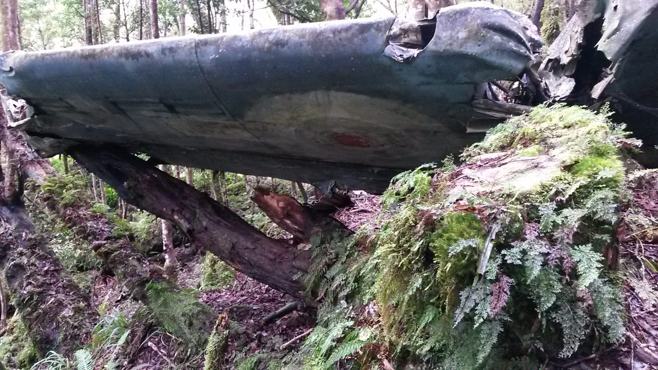
I'm wandering along when something white catches my eye ahead. My first thought is something man-made, as I get closer I have a random thought it might be part of a plane.

Closer still and another item comes into view - now I'm thinking it could be part of a helicopter.

I cast around and a short distance away there is the remains of a plane fuselage mashed against a tree. Beside it on the forest floor is a mangled seat and bits of plane are scattered across a wide area. Any thought that someone could survive such a crash are dispelled by the catastrophic forces evident in the shredded and dispersed debris.
It looks newer than any others I've seen and I guess it might be a plane from the 1970s. Given the location I'm pretty confident it is well known, but I hadn't heard about it before (not that I've looked). A quick internet search afterwards reveals it crashed in 1982 with three people killed.

As always, these sites set you thinking. The wreckage marks a real human tragedy, often involving the sudden, violent deaths of quite young aircrew (particularly in the war era crashes). Despite this, there's a sense of disconnection - this involved no-one I know. At best you're really just a tourist - at worst a voyeur. And the remnants are inevitably blurring and dissolving as moss, corrosion and the weather gradually obliterate the evidence - even the most resistant materials are slowly disappearing into the forest. It's hardly surprising then, that (with a few exceptions) there seems to be a tendency for trampers to be respectful of these places and not to interfere with them.
I look around the area for a while before taking a note of the altitude (probably close to accurate) and heading on down the spur - passing a few final pieces of debris on the way.


At 8.45 I'm at my second and last spot height for the weekend. The fourth to last on my list. It's every bit as remarkable as many other spot heights. It's also the point where I deviate from the line of the spur to follow a side spur that will take me slightly further down valley.
 |
| Fourth to last - three to go |
There's not much trail now but it is still pretty good going and I successfully navigate down to the flat top at 520m before a sharper drop to the junction I have targeted. It's 9.40 so, although time is still tight, I'm happy enough with progress.
The periodic drizzle has kept the river boulders slippery so I'm careful as I potter down valley. It's quite pleasant until I stumble across the evidence of a successful but brainless hunter. Half a deer is sitting in the river shallows with choice cuts removed and guts spilling into the water. The other half is a few metres down stream. So, if you know someone who was hunting in this area, with a .223, who left a carcass like that - tell them they're a twat.

In the interests of seeing new territory I follow the river bed all the way to Waitewaewae Forks instead of diverting onto the terraces on the true left at the appropriate point. The river immediately starts forming pools and deep sections by the banks so I have to cross frequently and have a few mid-drift wades. It's slower going than expected but I am at the forks by 11.40 so stop for a bite and study the map.
 |
| Waitewaewae Otaki Forks |
I reckon it will be about 20 minutes up stream with four side streams to reach my target spur. It's always hard to tell though - was that an unmarked trickle or a marked small stream? The last stream has been shifting a lot of stones so is quite distinctive and seems to make sense against the map. I top up water and start the climb.
I don't really think it is a used route but it's ok going. After about 200m the compass confirms I am on the right spur and I settle in for the grind. There's quite a bit of windfall. I disturb a deer on the way up - so far I have only heard them and I haven't heard any roaring. I wonder if it is the weather or if their habits have changed with the end of the roar.
The slope eases quite a way from the top, and it takes a long time to finally roll onto the ridge. I can't see a trail, but know that there is one to be found, so take a bearing and turn north (1.55).
The travel is a bit mucky. The trail comes and goes, there is a lot of regrowth and windfall, and areas of leatherwood to negotiate or bypass. I drop down the east slope to try to avoid the worst.
Once the marked clearings start there is a channel cut through the scrub, which is somewhat overgrown but still navigable. It's still claggy and drizzly and I'm not in the best frame of mind - I'm overly conscious of the clock ticking and a little nervous about navigating the western slopes in the dark. I haven't been able to get cell phone reception to confirm progress.
These are perfect conditions for a mistake - and I'd hate to disappoint. The word "Mick" on the map partly occludes a knob on my ridge - I climb this knob thinking it is Mick and take a bearing north. There's a bit of ground trail and although I am surprised at the lack of markers I bowl off down discounting the fact that the slope is a little greater than expected.
Getting suspicious, I check the altimeter - 794. This should have flattened at 830. Bugger.
I suspect I know what has happened, but the occasional gap in the trees gives no clues - just more clag. Back on the knob I find a trail and am soon on the way to Mick proper, where I find a quite well marked trail doing exactly what it should be doing. Things speed up but it's getting noticeably dimmer and there's a long way to go yet.
I'm thinking ahead - I want to keep a pace that will get me a good distance before dark. But as I drop the clag will lighten and as the sun sets it will light the western foothills.
Near pt 860 there's a wee plastic plane hanging on a tree, indicating where my trail heads down. I lose it at the top but am soon on the steeply dropping spur and generally finding my way. As predicted it starts to get lighter.
I give a nod to the site of the Ventura bomber crash on the way past but do not divert to visit the distinctive wing. Soon the path joins an old logging trail and things speed up again. Although dryer, it is still steep and slippery in places, so the best I can manage is a cautious jog at times.
At the bottom it's a bit dim but the track drops into a series of grassy clearings near a stream. It's not that well marked and I end up following the Waitohu Stream for a while before joining a wide platform that follows and crosses the stream a couple of times. It's pretty boggy in patches but generally quick going. I settle in for a few Ks before another couple of Ks on the access road.
Coming over a rise I see a silver car a few hundred meters away - it's the support crew. She's found her way past the quarry and to the end of the access road (bottom of the spur to 309). Apparently there's five gates but the signs are all about being careful, and don't prevent access.
I'm mightily relieved to be chucking sopping kit into rubbish bags at 5.30 and a K and a half earlier than expected.
Postscript
An eventful weekend. The Friday night walk in was more tiring than expected - I reckon this set me up for the truncated Saturday. Getting to Oriwa is somewhat familiar now - it's a good 'off track' route. I was pretty pleased with the choice of the spur down - keep an eye on the compass and the shape of the spur - the trail is better further down with lots of blue DoC triangles at various points.Mid-Otaki hut - never stayed there but I quite like the spot.
The spur up to Kelleher is an old route - a bit of windfall and no real marking - could be kinda tricky on the way down as the spur shape is a bit messy. Interesting at the top with the rocky outcrops, views and series of knobs up to Kelleher.
The Main Range is the Main Range. And Nichols Hut is Nichols Hut - just in the right spot for when I was running out of steam. The night time visitors were a gas.
The spur to 870? Well, it had a plane crash - that was unexpected. Surprisingly navigable at the top - some annoying windfall but a useful route to the valley floor.
The river is the river and should be treated with respect. It's worth knowing where to find the old trail, on the true left, if the flow is up at all.
I didn't enjoy the route out quite so much. But it is worth getting around this area as it us a useful access way and there a quite a few little byways.
Spot-heights - two more down and three to go. I have the exact trip in mind for the remainder but that will, I hope, be a story for another (not too distant) day.