Across the plains via Rongotea to Tangimoana Road, follow the Gorges to Sea Cycle way to North of Marton, leaving it to follow Makahou Road to Turakina Valley and up to join the Wild Rover (and the Tour route) at Mangatipona Road, Wild Rover to Whanganui, then Whanganui River Road to Koriniti.
Link to Map
Distance: 192 Km
Today marks a serious diversion from the Tour route. After a good breakfast and a leisurely start, instead of heading north to Ashhurst and thrashing around in the hills around Apiti, its west across the plains via the small town of Rongotea to join the Manawatu Gorges to Sea Cycle Trail.
It’s gloriously flat and the wind is largely tail so it’s quick travel across SH1 to follow Tangimoana and other roads up beside the Rangitikei river.
This part of the cycle route is not spectacular; basically flat farm land, a few busy road crossings and not a lot to see. During a pause for a snack three cyclists heading north up Tangimoana Rd stop for a chat. They are walking Te Araroa and borrowed bikes from the backpackers in Bulls but have decided to return them and walk as the wind is making things too unpleasant. They have a pretty tedious day in front of them but seem pretty cheerful about it.
My route crosses the Rangitikei River via Kakariki Road before a short section of SH 1 (wide shoulder and easy going) then across to Marton for lunch and essential supplies (iced coffee, pie and Vaseline).
The unfortunately named Tutaenui Road takes me north and into some gentle and picturesque hills to Turakina Valley Road, then up to join the tour route on Mangatipona Road on the route between Hunterville and Whanganui (the Wild Rover). Calls to the jet boat companies around 4pm determined that one is booked out so I reserve a space on the other. Bookings are not refundable so I have to cover the 110 km to Pipiriki by 10am tomorrow. No pressure.
 |
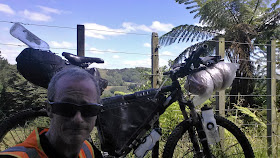
| Taking a break - Mangatipona Road |
It’s well after 5pm when I leave Whanganui up SH 4 so I’m pretty sure I won’t make the 78 odd km to Pipiriki tonight but intend to make a start. At the turn off to Whanganui Road the sun is setting, giving the chance to bask in the last light, fuel up, study the information boards, and put the lights on. There are a few settlements with accommodation including Koriniti which I figure is as far as I’m likely to get.
The Gentle Annie Hill is not high (170m) but I’m pretty pleased to get to the top and pause over the view across peaceful farming flats around the river surrounded by bush clad hills. The light dims as the road follows the winding river valley. It turns out that the whole length is sealed (barring road works) – last time I came through a fair chunk was gravel. The names are intriguing Atene (Athens), Koriniti (Corinth), Ranana (London) and Hiruharama (Jerusalem).
Many settlements have a Marae that seem to be in good shape and the roads are virtually deserted. I give one local a bit of a fright as he is hunting along the edge of the road with his rifle and is not expecting a bike to drift by in the gloom.
I’m aiming to stop at the Flying Fox at Koriniti but they have a sign insisting that bookings are required. I’m pretty weary now so stagger up the road a short distance and find a corner by a bridge to pitch my bivvy. It’s not a very comfortable night but I keep dry and am relieved to be off my feet.
Link to day four: Koriniti to Whakahoro
No comments:
Post a Comment